Synagogue nearby בית הכנסת גינת אגוז
Israel
Synagogue nearby בית הכנסת גינת אגוז
בית הכנסת גינת אגוז
ירושלים, ישראל
contacts phone
:
+972
Latitude:
31.7501164
, Longitude:
35.1858485
larger map & directions
read more
nearest Synagogue
232 m
בית כנסת
דרך אגודת ספורט בית"ר 1, ירושלים
Synagogue
read more
232 m
בית כנסת
Derech Agudat Sport Beitar 1, Jerusalem
Synagogue
read more
474 m
ברכת אברהם
ערד 5, ירושלים
Synagogue
read more
542 m
בית הכנסת זכור לאברהם
ירושלים
Synagogue
read more
576 m
בית הכנסת מנחת יהודה
ירושלים
Synagogue
read more
576 m
Yehuda Synagogue damper
Jerusalem
Synagogue
read more
765 m
בית הכנסת עש רוז ואײזיק טיילור
ירושלים
Synagogue
read more
765 m
The Rose and Isaac H. Taylor Synagogue
Jerusalem
Synagogue
read more
838 m
בית כנסת בנג'יו
Bar Yokhai Street 15, Jerusalem
Synagogue
read more
838 m
Benjio Synagogue
Bar Yokhai Street 15, Jerusalem
Synagogue
read more
873 m
ביכ היכל יעקב
ירושלים
Synagogue
read more
929 m
בית כנסת שערי רפואה
Jerusalem
Synagogue
read more
930 m
בית הכנסת גיבורי ישראל
בית הספר גבעת גונן
Synagogue
read more
935 m
Zechut Avot Synagogue
Jerusalem
Synagogue
read more
987 m
Synagogue Tamar Ifrah
Guatemala Street 18, Jerusalem
Synagogue
read more
988 m
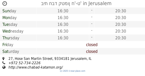
בית חבד קטמון ח'-ט'
Hose San Martin Street 27, Jerusalem
Synagogue
read more
988 m
בית חבד קטמון ח'-ט'
חוזה סן מרטין 27, ירושלים
Synagogue
read more
1.024 km
בית הכנסת לעדה האתיופית
ירושלים
Synagogue
read more
1.067 km
בית כנסת תפארת ישרים
14,, Guatemala Street 12, Jerusalem
Synagogue
read more
1.105 km
בית הכנסת ברית שלום
ירושלים
Synagogue
read more
1.329 km
בית הכנסת זכרון קדושים
Jerusalem
Synagogue
read more
1.329 km
בית הכנסת זכרון קדושים
ירושלים
Synagogue
read more
1.552 km
Keter Tora Synagogue
Jerusalem
Synagogue
read more
1.868 km
בית כנסת ר' חי טייב
ירושלים
Synagogue
read more
1.922 km
בית מדרש דחסידי סוכוטשוב-ראדומסק
החיד"א 4, ירושלים
Synagogue
read more
📑
all categories
Accounting
Administrative area level 1
Administrative area level 2
Airport
Amusement park
Aquarium
Art gallery
Atm
Bakery
Bank
Bar
Beauty salon
Bicycle store
Book store
Bowling alley
Bus station
Cafe
Campground
Car dealer
Car rental
Car repair
Car wash
Casino
Cemetery
Church
City hall
Clothing store
Colloquial area
Convenience store
Country
Courthouse
Dentist
Department store
Doctor
Electrician
Electronics store
Embassy
Establishment
Finance
Fire station
Florist
Food
Funeral home
Furniture store
Gas station
General contractor
Grocery or supermarket
Gym
Hair care
Hardware store
Health
Hindu Temple
Home goods store
Hospital
Insurance agency
Intersection
Jewelry store
Laundry
Lawyer
Library
Light rail station
Liquor store
Local government office
Locality
Locksmith
Lodging
Meal delivery
Meal takeaway
Mosque
Movie rental
Movie theater
Moving company
Museum
Natural feature
Neighborhood
Night club
Painter
Park
Parking
Pet store
Pharmacy
Physiotherapist
Place of worship
Plumber
Point of interest
Police
Political
Post office
Premise
Real estate agency
Restaurant
Roofing contractor
Route
Rv park, camping
School
Shoe store
Shopping mall
Spa
Stadium
Storage
Store
Subpremise
Subway station
Supermarket
Synagogue
Taxi stand
Train station
Transit station
Travel agency
University
Veterinary care
Zoo
administrative area level 3
administrative area level 4
sublocality level 1
↑