Synagogue nearby בית הכנסת לעדה האתיופית
Israel
Synagogue nearby בית הכנסת לעדה האתיופית
בית הכנסת לעדה האתיופית
ירושלים, ישראל
contacts phone
:
+972
Latitude:
31.753068
, Longitude:
35.196112
larger map & directions
read more
nearest Synagogue
103 m
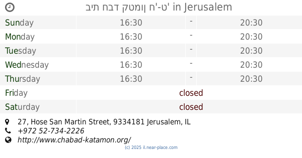
בית חבד קטמון ח'-ט'
Hose San Martin Street 27, Jerusalem
Synagogue
read more
103 m
בית חבד קטמון ח'-ט'
חוזה סן מרטין 27, ירושלים
Synagogue
read more
157 m
ביכ היכל יעקב
ירושלים
Synagogue
read more
188 m
בית כנסת בנג'יו
Bar Yokhai Street 15, Jerusalem
Synagogue
read more
245 m
בית כנסת המרכזי הצריף
יצחק שדה 1, ירושלים
Synagogue
read more
443 m
בית כנסת שערי רחמים
ירושלים
Synagogue
read more
474 m
Beit Yehudah Synagogue
Jerusalem
Synagogue
read more
478 m
בית חבד קטמון-גוננים
קנאי הגליל 4, ירושלים
Synagogue
read more
505 m
Nahar ha-Metaher Synagogue
Jerusalem
Synagogue
read more
546 m
Keter Tora Synagogue
Jerusalem
Synagogue
read more
697 m
Heikhal David Synagogue
Jerusalem
Synagogue
read more
778 m
היכל הפיס לנוער- בית הכנסת צדק תורה בציון
Nikkanor Street, Jerusalem
Synagogue
read more
865 m
Ohel Moshe Synagogue for North African Jewry
Jerusalem
Synagogue
read more
867 m
בית הכנסת המרכזי גבעת מרדכי
8,, Yitskhak David Man Street 6, Jerusalem
Synagogue
read more
953 m
ביכ גאולה
ירושלים
Synagogue
read more
985 m
משכן שמואל
Ha-Rav Gold Street 8, Jerusalem
Synagogue
read more
985 m
משכן שמואל
הרב גולד 8, ירושלים
Synagogue
read more
995 m
Chabad Givat Mordechai
Ha-Rav Gold Street 6, Jerusalem
Synagogue
read more
1.002 km
Am Ram Synagogue
Jerusalem
Synagogue
read more
1.035 km
בית הכנסת עש משה אהרון ומרים מוזס
ירושלים
Synagogue
read more
1.085 km
Shimon HaTzadik Synagogue
Jerusalem
Synagogue
read more
1.153 km
קהילת מבקשי דרך
שדרות ש"י עגנון 22, ירושלים
Synagogue
read more
1.271 km
בית הכנסת מנחת שלמה
ירושלים
Synagogue
read more
1.3 km
בית הכנסת תפארת צבי
סלמן מוצפי, ירושלים
Synagogue
read more
1.3 km
בית הכנסת תפארת צבי
Salman Mutsafi Street, Jerusalem
Synagogue
read more
📑
all categories
Accounting
Administrative area level 1
Administrative area level 2
Airport
Amusement park
Aquarium
Art gallery
Atm
Bakery
Bank
Bar
Beauty salon
Bicycle store
Book store
Bowling alley
Bus station
Cafe
Campground
Car dealer
Car rental
Car repair
Car wash
Casino
Cemetery
Church
City hall
Clothing store
Colloquial area
Convenience store
Country
Courthouse
Dentist
Department store
Doctor
Electrician
Electronics store
Embassy
Establishment
Finance
Fire station
Florist
Food
Funeral home
Furniture store
Gas station
General contractor
Grocery or supermarket
Gym
Hair care
Hardware store
Health
Hindu Temple
Home goods store
Hospital
Insurance agency
Intersection
Jewelry store
Laundry
Lawyer
Library
Light rail station
Liquor store
Local government office
Locality
Locksmith
Lodging
Meal delivery
Meal takeaway
Mosque
Movie rental
Movie theater
Moving company
Museum
Natural feature
Neighborhood
Night club
Painter
Park
Parking
Pet store
Pharmacy
Physiotherapist
Place of worship
Plumber
Point of interest
Police
Political
Post office
Premise
Real estate agency
Restaurant
Roofing contractor
Route
Rv park, camping
School
Shoe store
Shopping mall
Spa
Stadium
Storage
Store
Subpremise
Subway station
Supermarket
Synagogue
Taxi stand
Train station
Transit station
Travel agency
University
Veterinary care
Zoo
administrative area level 3
administrative area level 4
sublocality level 1
↑