Synagogue nearby Zechut Avot Synagogue
Israel
Synagogue nearby Zechut Avot Synagogue
Zechut Avot Synagogue
Иерусалим, Израиль
contacts phone
:
+972
Latitude:
31.7584951
, Longitude:
35.1849897
larger map & directions
read more
nearest Synagogue
313 m
Reitman Synagogue
Jerusalem
Synagogue
read more
313 m
בית הכנסת ריטמן
ירושלים
Synagogue
read more
420 m
Yehuda Synagogue damper
Jerusalem
Synagogue
read more
443 m
בית הכנסת תפארת צבי
סלמן מוצפי, ירושלים
Synagogue
read more
471 m
בית הכנסת מנחת שלמה
ירושלים
Synagogue
read more
499 m
Am Ram Synagogue
Jerusalem
Synagogue
read more
557 m
בית כנסת תפארת ישרים
14,, Guatemala Street 12, Jerusalem
Synagogue
read more
735 m
Tolna Synagogue
Ha-Pisga Street 60, Jerusalem
Synagogue
read more
773 m
לב שמח
Bayit Vagan Street 99, Jerusalem
Synagogue
read more
784 m
Beth Annaelle v'Yisrael
Yosef Khakhami Street 26, Jerusalem
Synagogue
read more
837 m
בית הכנסת זכרון קדושים
Jerusalem
Synagogue
read more
837 m
בית הכנסת זכרון קדושים
ירושלים
Synagogue
read more
859 m
The Rose and Isaac H. Taylor Synagogue
Jerusalem
Synagogue
read more
971 m
בית כנסת בית לוי
ירושלים
Synagogue
read more
971 m
סוכטשוב
Ha-Khida Street 4, Jerusalem
Synagogue
read more
980 m
בית כנסת חסידי סוכוטושב
הרב אברהם ח. שאג, ירושלים
Synagogue
read more
988 m
בית מדרש דחסידי סוכוטשוב-ראדומסק
החיד"א 4, ירושלים
Synagogue
read more
989 m
בית כנסת דחסידי סוכוטשוב-ראדומסק
Ha-Khida Street 4, Jerusalem
Synagogue
read more
998 m
בית כנסת נזר אהרון
תורה ועבודה 4, ירושלים
Synagogue
read more
1.056 km
בית הכנסת זכור לאברהם
ירושלים
Synagogue
read more
1.07 km
בית כנסת שערי רפואה
Jerusalem
Synagogue
read more
1.086 km
ביכ היכל יעקב
ירושלים
Synagogue
read more
1.115 km
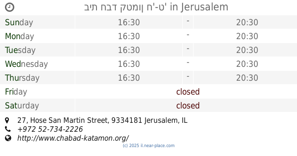
בית חבד קטמון ח'-ט'
Hose San Martin Street 27, Jerusalem
Synagogue
read more
1.115 km
בית חבד קטמון ח'-ט'
חוזה סן מרטין 27, ירושלים
Synagogue
read more
1.168 km
בית הכנסת הגדול בית שלמה
א.מ. שמורק 6-16, ירושלים
Synagogue
read more
📑
all categories
Accounting
Administrative area level 1
Administrative area level 2
Airport
Amusement park
Aquarium
Art gallery
Atm
Bakery
Bank
Bar
Beauty salon
Bicycle store
Book store
Bowling alley
Bus station
Cafe
Campground
Car dealer
Car rental
Car repair
Car wash
Casino
Cemetery
Church
City hall
Clothing store
Colloquial area
Convenience store
Country
Courthouse
Dentist
Department store
Doctor
Electrician
Electronics store
Embassy
Establishment
Finance
Fire station
Florist
Food
Funeral home
Furniture store
Gas station
General contractor
Grocery or supermarket
Gym
Hair care
Hardware store
Health
Hindu Temple
Home goods store
Hospital
Insurance agency
Intersection
Jewelry store
Laundry
Lawyer
Library
Light rail station
Liquor store
Local government office
Locality
Locksmith
Lodging
Meal delivery
Meal takeaway
Mosque
Movie rental
Movie theater
Moving company
Museum
Natural feature
Neighborhood
Night club
Painter
Park
Parking
Pet store
Pharmacy
Physiotherapist
Place of worship
Plumber
Point of interest
Police
Political
Post office
Premise
Real estate agency
Restaurant
Roofing contractor
Route
Rv park, camping
School
Shoe store
Shopping mall
Spa
Stadium
Storage
Store
Subpremise
Subway station
Supermarket
Synagogue
Taxi stand
Train station
Transit station
Travel agency
University
Veterinary care
Zoo
administrative area level 3
administrative area level 4
sublocality level 1
↑