Store nearby יינות ביתן
Israel
Store nearby יינות ביתן
יינות ביתן
Rishon LeTsiyon, Israel
contacts phone
:
+972
Latitude:
31.9730015
, Longitude:
34.7925013
larger map & directions
read more
nearest Store
803 m
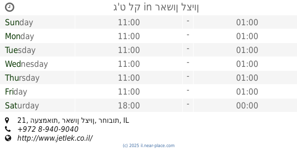
ג'ט לק
העצמאות 21, ראשון לציון
Store
read more
805 m
4 מובייל
החלמונית 20, ראשון לציון
Store
read more
805 m
4 מובייל
Ha-Khelmonit Street 20, Rishon LeTsiyon
Store
read more
850 m
אופטיקה צביון
שדרות בן גוריון 4, ראשון לציון
Store
read more
877 m
New toy store
Keren ha-Yesod Street 28, Rishon LeTsiyon
Store
read more
878 m
כמו גדולים
Ha-Khelmonit Street 30, Rishon LeTsiyon
Store
read more
911 m
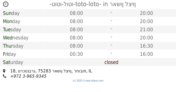
-טוטו-לוטו-toto-loto-
טרכטנברג 18, ראשון לציון
Store
read more
914 m
אביבה מכון קוסמטי
120, Rothschild Street, Rishon LeTsiyon
Store
read more
922 m
גלקסיה - טיסני ראשון
רוטשילד 114, ראשון לציון
Store
read more
924 m
פיטר פן צעצועים מתנות
טרכטנברג 18, ראשון לציון
Store
read more
957 m
סייבר טאטו
רוטשילד 119, ראשון לציון
Store
read more
966 m
הכל למוביל - קרטונים למעבר דירה וחומרי אריזה
יצחק בן צבי 10, ראשון לציון
Store
read more
1.005 km
Кравиц
Hahistadrut Street 6, Rishon LeTsiyon
Store
read more
1.02 km
נועלה יבוא והפצה
Ha-Sigalit Street, Holon
Store
read more
1.046 km
PetBuy פט ביי ראשון לציון
רוטשילד 76, ראשון לציון
Store
read more
1.082 km
iDry
רוטשילד 72, ראשון לציון
Store
read more
1.082 km
iDry
Rothschild Street 72, Rishon LeTsiyon
Store
read more
1.095 km
אנג'ויסטיק
Jabotinsky Street 51, Rishon LeTsiyon
Store
read more
1.165 km
ביג הובי
הרצל 50, ראשון לציון
Store
read more
1.211 km
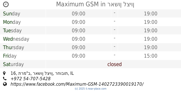
Maximum GSM
תרמ"ב 16, ראשון לציון
Store
read more
1.225 km
אלדו
הרצל 54, ראשון לציון
Store
read more
1.314 km
הובי גו'י פטס , מזון וציוד לבעלי חיים
Bialik Street 2, Rishon LeTsiyon
Store
read more
1.316 km
אוראל פון
ביאליק 1, ראשון לציון
Store
read more
1.346 km
ארנקי ראשון
Herzl Street 74, Rishon LeTsiyon
Store
read more
1.377 km
הלפרין
הרצל 78, ראשון לציון
Store
read more
📑
all categories
Accounting
Administrative area level 1
Administrative area level 2
Airport
Amusement park
Aquarium
Art gallery
Atm
Bakery
Bank
Bar
Beauty salon
Bicycle store
Book store
Bowling alley
Bus station
Cafe
Campground
Car dealer
Car rental
Car repair
Car wash
Casino
Cemetery
Church
City hall
Clothing store
Colloquial area
Convenience store
Country
Courthouse
Dentist
Department store
Doctor
Electrician
Electronics store
Embassy
Establishment
Finance
Fire station
Florist
Food
Funeral home
Furniture store
Gas station
General contractor
Grocery or supermarket
Gym
Hair care
Hardware store
Health
Hindu Temple
Home goods store
Hospital
Insurance agency
Intersection
Jewelry store
Laundry
Lawyer
Library
Light rail station
Liquor store
Local government office
Locality
Locksmith
Lodging
Meal delivery
Meal takeaway
Mosque
Movie rental
Movie theater
Moving company
Museum
Natural feature
Neighborhood
Night club
Painter
Park
Parking
Pet store
Pharmacy
Physiotherapist
Place of worship
Plumber
Point of interest
Police
Political
Post office
Premise
Real estate agency
Restaurant
Roofing contractor
Route
Rv park, camping
School
Shoe store
Shopping mall
Spa
Stadium
Storage
Store
Subpremise
Subway station
Supermarket
Synagogue
Taxi stand
Train station
Transit station
Travel agency
University
Veterinary care
Zoo
administrative area level 3
administrative area level 4
sublocality level 1
↑