School nearby תלמוד תורה
Israel
School nearby תלמוד תורה
תלמוד תורה
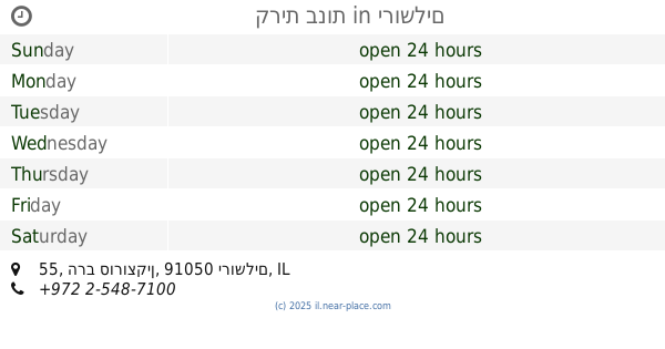
Tkhelet Mordekhai Street, Jerusalem, IL Израиль
contacts phone
:
+972
Latitude:
31.7923321
, Longitude:
35.2042772
larger map & directions
read more
nearest School
91 m
cabaret ecole
ירמיהו Yermiyahu, ירושלים
School
read more
108 m
מאור חיים פקודת אלעזר
אור אלחנן 28, ירושלים
School
read more
108 m
מאור חיים פקודת אלעזר
Or Elkhanan Street 28, Jerusalem
School
read more
513 m
תלמוד תורה רוממה
Jerusalem
School
read more
515 m
Rinas Bais Yaakov Seminary
Yermiyahu Street 24, Jerusalem
School
read more
599 m
Beit Yaakov Seminary Teachers (old school)
Minhat Yitshak Street 21, Jerusalem
School
read more
677 m
תת מסילת ישרים
ירושלים
School
read more
693 m
Talmud Torah Torah of truth Chabad Lubavitch
Hanna Street 25, Jerusalem
School
read more
704 m
בית ספר מיטב שובו ירושלים
רש"י 60, ירושלים
School
read more
714 m
אולפנת צביה
Yermiyahu Street 5, Jerusalem
School
read more
748 m
ביס דרכי אבות
ירושלים
School
read more
748 m
Darkei Avot School
Jerusalem
School
read more
806 m
בית יעקב סמינר הסניף
Malkei Israel Street 34, Jerusalem
School
read more
822 m
Beis Medrash L’Torah
הרב סורוצקין 45, ירושלים
School
read more
829 m
ביס מיימון
ירושלים
School
read more
900 m
קרית בנות
הרב סורוצקין 55, ירושלים
School
read more
929 m
Talmud Torah Tchekhnow
Pnina Street 11, Jerusalem
School
read more
935 m
בית ספר סוכת דוד
דורש טוב 18, ירושלים
School
read more
935 m
בית ספר סוכת דוד
Doresh Tov Street 18, Jerusalem
School
read more
949 m
Yeshivas Tiferes Yisroel
Sfat Emes 6, Jerusalem
School
read more
1.108 km
בית כנסת בית אהרון וישראל-קרליץ
Ezrat Tora Street 27, Jerusalem
School
read more
1.124 km
ישיבת המאירי
שדרות המאירי 11, ירושלים
School
read more
1.124 km
ישיבת המאירי
Sderot HaMe'iri 11, Jerusalem
School
read more
1.23 km
בית ספר אליאנס
Ki'akh Street 2, Jerusalem
School
read more
1.272 km
Amit Dror School
Kosovski Street 7, Jerusalem
School
read more
📑
all categories
Accounting
Administrative area level 1
Administrative area level 2
Airport
Amusement park
Aquarium
Art gallery
Atm
Bakery
Bank
Bar
Beauty salon
Bicycle store
Book store
Bowling alley
Bus station
Cafe
Campground
Car dealer
Car rental
Car repair
Car wash
Casino
Cemetery
Church
City hall
Clothing store
Colloquial area
Convenience store
Country
Courthouse
Dentist
Department store
Doctor
Electrician
Electronics store
Embassy
Establishment
Finance
Fire station
Florist
Food
Funeral home
Furniture store
Gas station
General contractor
Grocery or supermarket
Gym
Hair care
Hardware store
Health
Hindu Temple
Home goods store
Hospital
Insurance agency
Intersection
Jewelry store
Laundry
Lawyer
Library
Light rail station
Liquor store
Local government office
Locality
Locksmith
Lodging
Meal delivery
Meal takeaway
Mosque
Movie rental
Movie theater
Moving company
Museum
Natural feature
Neighborhood
Night club
Painter
Park
Parking
Pet store
Pharmacy
Physiotherapist
Place of worship
Plumber
Point of interest
Police
Political
Post office
Premise
Real estate agency
Restaurant
Roofing contractor
Route
Rv park, camping
School
Shoe store
Shopping mall
Spa
Stadium
Storage
Store
Subpremise
Subway station
Supermarket
Synagogue
Taxi stand
Train station
Transit station
Travel agency
University
Veterinary care
Zoo
administrative area level 3
administrative area level 4
sublocality level 1
↑