School nearby Yeshivas Tiferes Yisroel
Israel
School nearby Yeshivas Tiferes Yisroel
Yeshivas Tiferes Yisroel
Sfat Emes 6, Jerusalem, ישראל
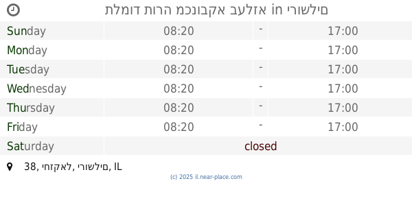
contacts phone
:
+972
Latitude:
31.7864975
, Longitude:
35.21161
larger map & directions
read more
nearest School
246 m
בית ספר מיטב שובו ירושלים
רש"י 60, ירושלים
School
read more
437 m
בית יעקב סמינר הסניף
Malkei Israel Street 34, Jerusalem
School
read more
448 m
סמינר בית יעקב נתיב החינוך רח' דוד ילין 13 ירושלים
דוד ילין 13, ירושלים
School
read more
495 m
תת מסילת ישרים
ירושלים
School
read more
527 m
Or Chaya
דוד ילין 2, ירושלים
School
read more
569 m
קוויקס הכל ב 5 שח
Yona Street 2-4, Jerusalem
School
read more
587 m
פעימות מרכז תופים
Ben Yehuda 34, Jerusalem
School
read more
609 m
אולפנת צביה
Yermiyahu Street 5, Jerusalem
School
read more
613 m
Neve tsvi
Betsal'el Street 22, Jerusalem
School
read more
636 m
סקולה
Malki St 6, Jerusalem
School
read more
728 m
Rinas Bais Yaakov Seminary
Yermiyahu Street 24, Jerusalem
School
read more
758 m
Beit Yaakov Seminary Teachers (old school)
Minhat Yitshak Street 21, Jerusalem
School
read more
760 m
בית יתומים ציון בלומנטל
Yekhezkel Street 5, Jerusalem
School
read more
770 m
Lycée Français De Jérusalem
Nevi'im, Ha-Nevi'im Street 66, Jerusalem
School
read more
914 m
אנקרי בית ספר
Herbert Samuel Street, Jerusalem
School
read more
929 m
מתימן יבוא
תרמ"ב 6, ירושלים
School
read more
966 m
Yeshiva Noam HaTalmud
Sha'arei Khesed Street 27, Jerusalem
School
read more
982 m
Talmud Torah Tchekhnow
Pnina Street 11, Jerusalem
School
read more
1.027 km
בית הספר התיכון וחטיבת הבניים הניסויי
הלל 28, ירושלים
School
read more
1.031 km
מאור חיים פקודת אלעזר
Or Elkhanan Street 28, Jerusalem
School
read more
1.038 km
בית הספר הניסויי היסודי
ירושלים
School
read more
1.058 km
תלמוד תורה שמע
Rabenu Gershom Street 15, Jerusalem
School
read more
1.063 km
ישיבת חכמת התורה ותפארתה
Bar Ilan, Jerusalem
School
read more
1.109 km
תלמוד תורה מכנובקא בעלזא
יחזקאל 38, ירושלים
School
read more
1.145 km
Talmud Torah Karlin Stolin
Shimshon Polanski Street 2, Jerusalem
School
read more
📑
all categories
Accounting
Administrative area level 1
Administrative area level 2
Airport
Amusement park
Aquarium
Art gallery
Atm
Bakery
Bank
Bar
Beauty salon
Bicycle store
Book store
Bowling alley
Bus station
Cafe
Campground
Car dealer
Car rental
Car repair
Car wash
Casino
Cemetery
Church
City hall
Clothing store
Colloquial area
Convenience store
Country
Courthouse
Dentist
Department store
Doctor
Electrician
Electronics store
Embassy
Establishment
Finance
Fire station
Florist
Food
Funeral home
Furniture store
Gas station
General contractor
Grocery or supermarket
Gym
Hair care
Hardware store
Health
Hindu Temple
Home goods store
Hospital
Insurance agency
Intersection
Jewelry store
Laundry
Lawyer
Library
Light rail station
Liquor store
Local government office
Locality
Locksmith
Lodging
Meal delivery
Meal takeaway
Mosque
Movie rental
Movie theater
Moving company
Museum
Natural feature
Neighborhood
Night club
Painter
Park
Parking
Pet store
Pharmacy
Physiotherapist
Place of worship
Plumber
Point of interest
Police
Political
Post office
Premise
Real estate agency
Restaurant
Roofing contractor
Route
Rv park, camping
School
Shoe store
Shopping mall
Spa
Stadium
Storage
Store
Subpremise
Subway station
Supermarket
Synagogue
Taxi stand
Train station
Transit station
Travel agency
University
Veterinary care
Zoo
administrative area level 3
administrative area level 4
sublocality level 1
↑