Restaurant nearby פיצריית אריה
Israel
Restaurant nearby פיצריית אריה
פיצריית אריה
Birya Израиль
contacts phone
:
+972
Latitude:
32.9775028
, Longitude:
35.5024169
read more
nearest Restaurant
פיצריית אריה
ביריה
Restaurant
read more
92 m
חוות בת יער
ביריה
Restaurant
read more
92 m
חוות בת יער
Birya
Restaurant
read more
537 m
סעודה בגן עדן
33, הגדוד השלישי, Tsfat
Restaurant
Food
Point of interest
Establishment
read more
564 m
מסעדת צפתא
Ha-Gdud ha-Shlishi Street 106, Safed
Restaurant
read more
698 m
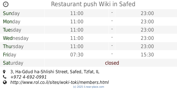
Restaurant push Wiki
קניון שערי העיר, הגדוד השלישי 3, צפת
Restaurant
read more
698 m
Restaurant push Wiki
Sha'are Ha'Ir Mall, Ha-Gdud ha-Shlishi Street 3, Safed
Restaurant
Food
Point of interest
Establishment
read more
701 m
פיצה פלרמו
צפת
Restaurant
read more
956 m
Baba baguette
Ha-Rabi mi-Lubavitch Street 4, Safed
Restaurant
read more
956 m
באבא באגט
הרבי מלובאוויטש 4, צפת
Restaurant
read more
958 m
ברביקיו
ירושלים 2, צפת
Restaurant
read more
1.011 km
האר"י 8
האר"י 8, צפת
Restaurant
read more
1.031 km
פיצה בעתיקה
Jerusalem Street 11, Safed
Restaurant
read more
1.081 km
קפה דגנים
Jerusalem Street 24, Safed
Cafe
Restaurant
Food
Store
Point of interest
Establishment
read more
1.172 km
מסעדת מנדי'ס צפת
Jerusalem Street 29, Safed
Restaurant
read more
1.185 km
פריקסה זהבה
מגיני צפת, צפת
Restaurant
read more
1.193 km
פלאפל יצחק
Jerusalem Street 28, Safed
Restaurant
read more
1.214 km
פיצה צפת
Jerusalem Street 35, Safed
Restaurant
read more
1.312 km
Tree of Life Cafe
5, Meginei Tsfat Street, Safed
Restaurant
read more
1.312 km
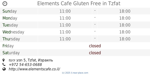
Elements Cafe Gluten Free
מגיני צפת 5, Tzfat
Restaurant
read more
1.346 km
Grill Bar
Safed
Restaurant
read more
1.346 km
Grill Bar
צפת
Restaurant
read more
1.35 km
Falafel & Pizza Hakikar
Safed
Restaurant
read more
1.35 km
Falafel & Pizza Hakikar
צפת
Restaurant
read more
1.403 km
Ronen at Azamara
Beit Yosef Street 6, Safed
Restaurant
read more
📑
all categories
Accounting
Administrative area level 1
Administrative area level 2
Airport
Amusement park
Aquarium
Art gallery
Atm
Bakery
Bank
Bar
Beauty salon
Bicycle store
Book store
Bowling alley
Bus station
Cafe
Campground
Car dealer
Car rental
Car repair
Car wash
Casino
Cemetery
Church
City hall
Clothing store
Colloquial area
Convenience store
Country
Courthouse
Dentist
Department store
Doctor
Electrician
Electronics store
Embassy
Establishment
Finance
Fire station
Florist
Food
Funeral home
Furniture store
Gas station
General contractor
Grocery or supermarket
Gym
Hair care
Hardware store
Health
Hindu Temple
Home goods store
Hospital
Insurance agency
Intersection
Jewelry store
Laundry
Lawyer
Library
Light rail station
Liquor store
Local government office
Locality
Locksmith
Lodging
Meal delivery
Meal takeaway
Mosque
Movie rental
Movie theater
Moving company
Museum
Natural feature
Neighborhood
Night club
Painter
Park
Parking
Pet store
Pharmacy
Physiotherapist
Place of worship
Plumber
Point of interest
Police
Political
Post office
Premise
Real estate agency
Restaurant
Roofing contractor
Route
Rv park, camping
School
Shoe store
Shopping mall
Spa
Stadium
Storage
Store
Subpremise
Subway station
Supermarket
Synagogue
Taxi stand
Train station
Transit station
Travel agency
University
Veterinary care
Zoo
administrative area level 3
administrative area level 4
sublocality level 1
↑