Restaurant nearby פלאפל יצחק
Israel
Restaurant nearby פלאפל יצחק
פלאפל יצחק
28, Jerusalem Street, Safed, Tzfat, IL Izrael
contacts phone
:
+972
Latitude:
32.9701172
, Longitude:
35.4931355
larger map & directions
read more
nearest Restaurant
10 m
פריקסה זהבה
מגיני צפת, צפת
Restaurant
read more
116 m
קפה דגנים
Jerusalem Street 24, Safed
Cafe
Restaurant
Food
Store
Point of interest
Establishment
read more
120 m
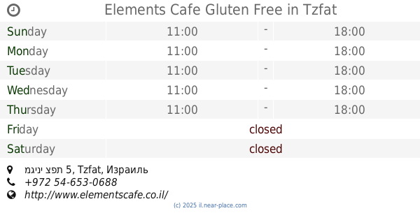
Elements Cafe Gluten Free
מגיני צפת 5, Tzfat
Restaurant
read more
161 m
Falafel & Pizza Hakikar
צפת
Restaurant
read more
161 m
Falafel & Pizza Hakikar
Safed
Restaurant
read more
164 m
פיצה בעתיקה
Jerusalem Street 11, Safed
Restaurant
read more
207 m
פלאפל סביח
צפת
Restaurant
read more
210 m
Shawarma Jerusalem
Jerusalem Street 47, Safed
Restaurant
read more
214 m
Ronen at Azamara
Beit Yosef Street 6, Safed
Restaurant
read more
325 m
Ahrele
ירושלים 59, צפת
Restaurant
read more
449 m
חומוס אבו יובי
ארלוזורוב 148, צפת
Restaurant
read more
462 m
The Falafel Of Lalo
Jerusalem Street 76, Safed
Restaurant
read more
483 m
מקסימיליאן
ארלוזורוב 2, צפת
Restaurant
read more
483 m
Maximilian caffe
Arlozorov Street 2, Safed
Restaurant
read more
484 m
שניצל בטעמים
Jerusalem Street 89, Safed
Restaurant
read more
484 m
שניצל בטעמים
ירושלים 89, צפת
Restaurant
read more
491 m
שניצליה צפת
Jerusalem Street 89, Safed
Restaurant
Food
Point of interest
Establishment
read more
493 m
מסעדת הקשתות
Arlozorov Street 71, Safed
Restaurant
Food
Point of interest
Establishment
read more
493 m
פלאפל קליפרוני'
ירושלים 84-86, Safed
Restaurant
read more
497 m
The falafel and shwarma
Jerusalem Street 84-86, Safed
Restaurant
read more
510 m
שווארמה
Jerusalem Street 88, Safed
Restaurant
Point of interest
Food
Establishment
read more
567 m
פיצה פאן
HaPalmach Street 77, Safed
Restaurant
Food
Point of interest
Establishment
read more
1.077 km
Restaurant Daboosh
אזור התעשיה החדש, Safed
Restaurant
read more
1.193 km
פיצריית אריה
ביריה
Restaurant
read more
1.285 km
חוות בת יער
Birya
Restaurant
read more
📑
all categories
Accounting
Administrative area level 1
Administrative area level 2
Airport
Amusement park
Aquarium
Art gallery
Atm
Bakery
Bank
Bar
Beauty salon
Bicycle store
Book store
Bowling alley
Bus station
Cafe
Campground
Car dealer
Car rental
Car repair
Car wash
Casino
Cemetery
Church
City hall
Clothing store
Colloquial area
Convenience store
Country
Courthouse
Dentist
Department store
Doctor
Electrician
Electronics store
Embassy
Establishment
Finance
Fire station
Florist
Food
Funeral home
Furniture store
Gas station
General contractor
Grocery or supermarket
Gym
Hair care
Hardware store
Health
Hindu Temple
Home goods store
Hospital
Insurance agency
Intersection
Jewelry store
Laundry
Lawyer
Library
Light rail station
Liquor store
Local government office
Locality
Locksmith
Lodging
Meal delivery
Meal takeaway
Mosque
Movie rental
Movie theater
Moving company
Museum
Natural feature
Neighborhood
Night club
Painter
Park
Parking
Pet store
Pharmacy
Physiotherapist
Place of worship
Plumber
Point of interest
Police
Political
Post office
Premise
Real estate agency
Restaurant
Roofing contractor
Route
Rv park, camping
School
Shoe store
Shopping mall
Spa
Stadium
Storage
Store
Subpremise
Subway station
Supermarket
Synagogue
Taxi stand
Train station
Transit station
Travel agency
University
Veterinary care
Zoo
administrative area level 3
administrative area level 4
sublocality level 1
↑