Pharmacy nearby صيدلية البستان
Israel
Pharmacy nearby صيدلية البستان
صيدلية البستان
כפר מנדא, ישראל
contacts phone
:
+972
Latitude:
32.8076976
, Longitude:
35.2598654
larger map & directions
read more
nearest Pharmacy
صيدلية البستان
Kafr Manda
Pharmacy
read more
283 m
בית מרקחת כללית
Kafr Manda
Pharmacy
read more
4.986 km
בית מרקחת ביר אלמכסור
Bir al-Maksur
Pharmacy
read more
4.986 km
בית מרקחת ביר אלמכסור
ביר אל-מכסור
Pharmacy
read more
5.057 km
כללית - בית מרקחת
ביר אל-מכסור
Pharmacy
read more
5.057 km
Clalit
Bir al-Maksur
Pharmacy
read more
5.057 km
כללית - בית מרקחת
Bir al-Maksur
Pharmacy
read more
7.275 km
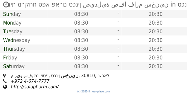
בית מרקחת ספא פארם סכנין صيدلية صفا فارم سخنين
ماريوسف, מר יוסף, סכנין سخنين
Pharmacy
read more
7.711 km
בית מרקחת אל שיפא שפרעם
רחוב חסן נימר 20200, שפרעם
Pharmacy
read more
10.456 km
בית מרקחת נוגידאת
בועיינה-נוג'ידאת
Pharmacy
read more
11.154 km
כללית בית מרקחת
ריינה
Pharmacy
read more
11.892 km
כללית - בית מרקחת
צבי הרר 35, קרית אתא
Pharmacy
read more
12.14 km
Universe Clips Har Yona
Nazareth Iliit
Pharmacy
read more
12.15 km
صيدلية ابن سينا
19, HaGalil Street, Nazareth
Pharmacy
read more
12.627 km
סופר-פארם נצרת
קולנוע דיאנה, Nazareth
Pharmacy
read more
12.689 km
Поликлиника Клалит
Nazareth
Pharmacy
read more
12.986 km
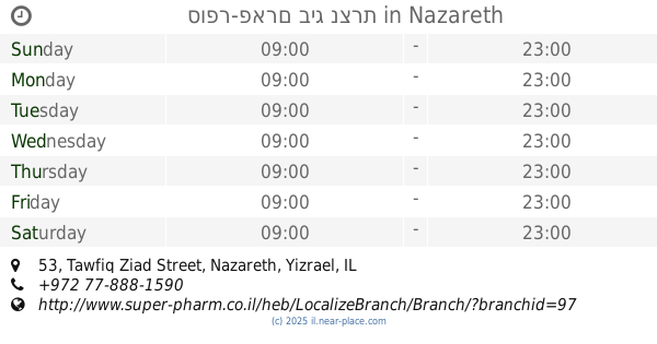
סופר-פארם ביג נצרת
Tawfiq Ziad Street 53, Nazareth
Pharmacy
read more
13.424 km
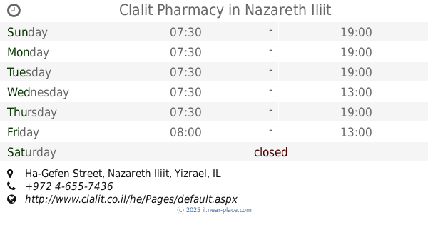
Clalit Pharmacy
Ha-Gefen Street, Nazareth Iliit
Pharmacy
read more
14.112 km
Migdal Pharmacy
Nitsanim Street 39, Migdal HaEmek
Pharmacy
read more
14.159 km
Clalit Pharmacy
דייר אל אסד 1, כביש ראשי, Deir al-Asad
Pharmacy
read more
14.208 km
פארם ביענה
דיר אל-אסד
Pharmacy
read more
14.688 km
New Pharm
Mekor Baruch Street 6, Kiryat Ata
Pharmacy
read more
14.695 km
Clalit Pharmacy
HaEla Street 2, Migdal HaEmek
Pharmacy
read more
14.798 km
New Pharm
Ma'ale Kamon Street 5, Karmiel
Pharmacy
read more
15.307 km
New Pharm
Israel
Pharmacy
read more
📑
all categories
Accounting
Administrative area level 1
Administrative area level 2
Airport
Amusement park
Aquarium
Art gallery
Atm
Bakery
Bank
Bar
Beauty salon
Bicycle store
Book store
Bowling alley
Bus station
Cafe
Campground
Car dealer
Car rental
Car repair
Car wash
Casino
Cemetery
Church
City hall
Clothing store
Colloquial area
Convenience store
Country
Courthouse
Dentist
Department store
Doctor
Electrician
Electronics store
Embassy
Establishment
Finance
Fire station
Florist
Food
Funeral home
Furniture store
Gas station
General contractor
Grocery or supermarket
Gym
Hair care
Hardware store
Health
Hindu Temple
Home goods store
Hospital
Insurance agency
Intersection
Jewelry store
Laundry
Lawyer
Library
Light rail station
Liquor store
Local government office
Locality
Locksmith
Lodging
Meal delivery
Meal takeaway
Mosque
Movie rental
Movie theater
Moving company
Museum
Natural feature
Neighborhood
Night club
Painter
Park
Parking
Pet store
Pharmacy
Physiotherapist
Place of worship
Plumber
Point of interest
Police
Political
Post office
Premise
Real estate agency
Restaurant
Roofing contractor
Route
Rv park, camping
School
Shoe store
Shopping mall
Spa
Stadium
Storage
Store
Subpremise
Subway station
Supermarket
Synagogue
Taxi stand
Train station
Transit station
Travel agency
University
Veterinary care
Zoo
administrative area level 3
administrative area level 4
sublocality level 1
↑