Pharmacy nearby כללית - בית מרקחת
Israel
Pharmacy nearby כללית - בית מרקחת
כללית - בית מרקחת
Bir al-Maksur Израиль
contacts phone
:
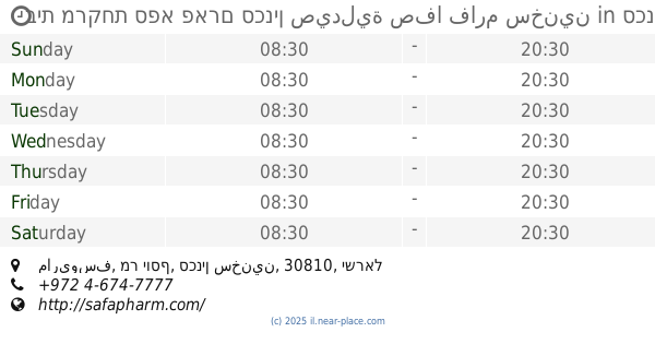
+972
Latitude:
32.775295
, Longitude:
35.221897
read more
nearest Pharmacy
Clalit
Bir al-Maksur
Pharmacy
read more
כללית - בית מרקחת
ביר אל-מכסור
Pharmacy
read more
148 m
בית מרקחת ביר אלמכסור
Bir al-Maksur
Pharmacy
read more
148 m
בית מרקחת ביר אלמכסור
ביר אל-מכסור
Pharmacy
read more
4.1 km
Clalit Pharmacy
זרזיר, Ka'abiyye-Tabbash-Hajajre
Pharmacy
read more
4.1 km
כללית בית מרקחת
זרזיר, כעביה טבאש חג'אג'רה
Pharmacy
read more
4.78 km
אבן סינא שפרעם
שפרעם
Pharmacy
read more
4.875 km
בית מרקחת כללית
Kafr Manda
Pharmacy
read more
4.915 km
בית מרקחת המרכז
7626, זרזיר
Pharmacy
read more
4.915 km
בית מרקחת המרכז
7626, Zarzir
Pharmacy
read more
5.057 km
صيدلية البستان
Kafr Manda
Pharmacy
read more
5.057 km
صيدلية البستان
כפר מנדא
Pharmacy
read more
5.271 km
Pharmacy
שמשית
Pharmacy
read more
5.271 km
Pharmacy
Shimshit
Pharmacy
read more
5.389 km
כללית - בית מרקחת
שפרעם, דואר שפרעם, שפרעם
Pharmacy
read more
5.413 km
דרגסטור
Tawfiq Ziad Street, Shefa-'Amr
Pharmacy
read more
5.469 km
בית מרקחת אל שיפא שפרעם
רחוב חסן נימר 20200, שפרעם
Pharmacy
read more
5.469 km
Al Shifa Pharmacy Shfar'am
Hasan Nimaer Street 20200, Shefa-'Amr
Pharmacy
read more
5.477 km
מרכז שפרעם ארמלי
שפרעם
Pharmacy
read more
5.695 km
Central Pharm
Shefa-'Amr
Pharmacy
read more
5.761 km
صيدلية الرازي
شارع خارت ألسك،, Shefa-'Amr
Pharmacy
read more
10.251 km
New Pharm
Israel
Pharmacy
read more
10.866 km
כללית בית מרקחת
ריינה
Pharmacy
read more
12.2 km
בית מרקחת ספא פארם סכנין صيدلية صفا فارم سخنين
ماريوسف, מר יוסף, סכנין سخنين
Pharmacy
read more
16.704 km
Clalit Pharmacy
HaNuriyot Street 2, Yokne'am Illit
Pharmacy
read more
📑
all categories
Accounting
Administrative area level 1
Administrative area level 2
Airport
Amusement park
Aquarium
Art gallery
Atm
Bakery
Bank
Bar
Beauty salon
Bicycle store
Book store
Bowling alley
Bus station
Cafe
Campground
Car dealer
Car rental
Car repair
Car wash
Casino
Cemetery
Church
City hall
Clothing store
Colloquial area
Convenience store
Country
Courthouse
Dentist
Department store
Doctor
Electrician
Electronics store
Embassy
Establishment
Finance
Fire station
Florist
Food
Funeral home
Furniture store
Gas station
General contractor
Grocery or supermarket
Gym
Hair care
Hardware store
Health
Hindu Temple
Home goods store
Hospital
Insurance agency
Intersection
Jewelry store
Laundry
Lawyer
Library
Light rail station
Liquor store
Local government office
Locality
Locksmith
Lodging
Meal delivery
Meal takeaway
Mosque
Movie rental
Movie theater
Moving company
Museum
Natural feature
Neighborhood
Night club
Painter
Park
Parking
Pet store
Pharmacy
Physiotherapist
Place of worship
Plumber
Point of interest
Police
Political
Post office
Premise
Real estate agency
Restaurant
Roofing contractor
Route
Rv park, camping
School
Shoe store
Shopping mall
Spa
Stadium
Storage
Store
Subpremise
Subway station
Supermarket
Synagogue
Taxi stand
Train station
Transit station
Travel agency
University
Veterinary care
Zoo
administrative area level 3
administrative area level 4
sublocality level 1
↑