Pharmacy nearby Поликлиника Клалит
Israel
Pharmacy nearby Поликлиника Клалит
Поликлиника Клалит
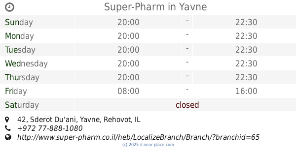
42, Sderot Du'ani, Yavne, Rehovot, IL Израиль
contacts phone
:
+972 *2700
website:
www.clalit.co.il
Latitude:
31.8695063
, Longitude:
34.744108
larger map & directions
read more
nearest Pharmacy
33 m
Супер-Фарм
Sderot Du'ani 42, Yavne
Pharmacy
read more
33 m
Super-Pharm
Sderot Du'ani 42, Yavne
Pharmacy
read more
205 m
מכבי פארם
גיבורי החיל, יבנה
Pharmacy
read more
205 m
מכבי פארם
Giborei ha-Khayil Street, Yavne
Pharmacy
read more
604 m
Yavne
Yavne
Pharmacy
read more
819 m
Поликлиника Клалит
Ha-Dekel Street 6, Yavne
Pharmacy
read more
819 m
Clalit
Ha-Dekel Street 6, Yavne
Pharmacy
read more
827 m
כללית - בית מרקחת
Ha-Dekel Street 6, Yavne
Pharmacy
read more
827 m
כללית - בית מרקחת
הדקל 6, יבנה
Pharmacy
read more
872 m
סופר-פארם יבנה הירוקה
הדוגית 16, יבנה
Pharmacy
read more
872 m
סופר-פארם יבנה הירוקה
HaDogit Street 16, Yavne
Pharmacy
read more
930 m
Yavne Hiper Pharm
Yavne
Pharmacy
read more
1.235 km
הלן פארם יבנה
הזית 188, יבנה
Pharmacy
read more
2.052 km
סופר-פארם הקישון יבנה
שד' ירושלים פינת הקישון 9, יבנה
Pharmacy
read more
2.052 km
סופר פארם
שד' ירושלים פינת הקישון 9, Yavne
Pharmacy
read more
2.052 km
סופר-פארם הקישון יבנה
שד' ירושלים פינת הקישון 9, Yavne
Pharmacy
read more
4.731 km
סופר-פארם רחובות ההולנדית
הר-צופים פינת יעקוב פרי, Rehovot
Pharmacy
read more
4.737 km
Super-Pharm
הר-הצופים 74, רחובות
Pharmacy
read more
4.737 km
סופר פארם
הר-הצופים 74, רחובות
Pharmacy
read more
5.448 km
miyo
דרך הים 2, Rehovot
Pharmacy
read more
7.028 km
בית מרקחת מאוחדת
בנימין 7, רחובות
Pharmacy
read more
7.953 km
Clalit
Palmakh Street 17, Rehovot
Pharmacy
read more
8.135 km
S.r.m.farm Center
ויצמן 8, נס ציונה
Pharmacy
read more
12.383 km
שפירא
Haim Moshe Shapira Street 22, Ashdod
Pharmacy
read more
16.773 km
Meuhedet
הרבי מליובאוויטש 4, Kfar Habad
Pharmacy
read more
📑
all categories
Accounting
Administrative area level 1
Administrative area level 2
Airport
Amusement park
Aquarium
Art gallery
Atm
Bakery
Bank
Bar
Beauty salon
Bicycle store
Book store
Bowling alley
Bus station
Cafe
Campground
Car dealer
Car rental
Car repair
Car wash
Casino
Cemetery
Church
City hall
Clothing store
Colloquial area
Convenience store
Country
Courthouse
Dentist
Department store
Doctor
Electrician
Electronics store
Embassy
Establishment
Finance
Fire station
Florist
Food
Funeral home
Furniture store
Gas station
General contractor
Grocery or supermarket
Gym
Hair care
Hardware store
Health
Hindu Temple
Home goods store
Hospital
Insurance agency
Intersection
Jewelry store
Laundry
Lawyer
Library
Light rail station
Liquor store
Local government office
Locality
Locksmith
Lodging
Meal delivery
Meal takeaway
Mosque
Movie rental
Movie theater
Moving company
Museum
Natural feature
Neighborhood
Night club
Painter
Park
Parking
Pet store
Pharmacy
Physiotherapist
Place of worship
Plumber
Point of interest
Police
Political
Post office
Premise
Real estate agency
Restaurant
Roofing contractor
Route
Rv park, camping
School
Shoe store
Shopping mall
Spa
Stadium
Storage
Store
Subpremise
Subway station
Supermarket
Synagogue
Taxi stand
Train station
Transit station
Travel agency
University
Veterinary care
Zoo
administrative area level 3
administrative area level 4
sublocality level 1
↑