Pharmacy nearby Meuhedet
Israel
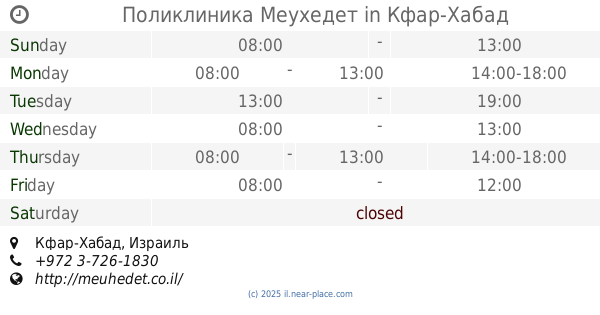
Pharmacy nearby Meuhedet
Meuhedet
הרבי מליובאוויטש 4, Kfar Habad, Israel
contacts phone
:
+972 3-726-1830
website:
meuhedet.co.il
Latitude:
31.99163
, Longitude:
34.8484769
larger map & directions
read more
nearest Pharmacy
מאוחדת פארם כפר חבד
הרבי מליובאוויטש 4, כפר חב"ד
Pharmacy
read more
מאוחדת פארם כפר חבד
הרבי מליובאוויטש 4, Kfar Habad
Pharmacy
read more
Поликлиника Меухедет
Kfar Habad
Pharmacy
read more
Поликлиника Меухедет
הרבי מליובאוויטש 4, Kfar Habad
Pharmacy
read more
155 m
Поликлиника Клалит
Kfar Habad
Pharmacy
read more
1.779 km
מעיין חיים
Trumpeldor Street 20, Beit Dagan
Pharmacy
read more
1.779 km
מעיין חיים
טרומפלדור 20, בית דגן
Pharmacy
read more
1.974 km
כללית בית מרקחת
שדרות מנחם בגין 27, בית דגן
Pharmacy
read more
1.974 km
Clalit Pharmacy
Sderot Menachem Begin 27, Beit Dagan
Pharmacy
read more
1.974 km
Поликлиника Клалит
Sderot Menachem Begin 27, Beit Dagan
Pharmacy
read more
2.659 km
בית מרקחת
Be'er Ya'akov
Pharmacy
read more
4.216 km
Contact - Pharm Ltd.
מתחם חצי חינם, המרכבה 31, חולון
Pharmacy
read more
4.312 km
Clalit
David El'azar Street 21, Or Yehuda
Pharmacy
read more
4.512 km
Поликлиника Клалит
Pinsker Street 31, Rishon LeTsiyon
Pharmacy
read more
4.776 km
טבע הדברות
Halahav Street 2, Holon
Pharmacy
read more
4.846 km
Шуферсаль
Holon
Pharmacy
read more
4.858 km
פארמה 10
ראשון לציון
Pharmacy
read more
4.864 km
Clalit Pharmacy
Sderot Ya'akov 50, Rishon LeTsiyon
Pharmacy
read more
4.917 km
Поликлиника Клалит
Weizman Street 25, Azor
Pharmacy
read more
4.935 km
Karlan
Rishon LeTsiyon
Pharmacy
read more
5.162 km
Поликлиника Клалит
Derech Moshe Dayan 3, Yehud
Pharmacy
read more
5.171 km
ניו פארם - קניון סביונים
Derech Moshe Dayan 3, Yehud
Pharmacy
read more
5.449 km
Super-Pharm
Rothschild Street 45, Rishon LeTsiyon
Pharmacy
read more
5.757 km
Ma'ayan Hayim
Azor
Pharmacy
read more
5.788 km
בית מרקחת ישראל
Ashkenazi Street 17, Yehud
Pharmacy
read more
📑
all categories
Accounting
Administrative area level 1
Administrative area level 2
Airport
Amusement park
Aquarium
Art gallery
Atm
Bakery
Bank
Bar
Beauty salon
Bicycle store
Book store
Bowling alley
Bus station
Cafe
Campground
Car dealer
Car rental
Car repair
Car wash
Casino
Cemetery
Church
City hall
Clothing store
Colloquial area
Convenience store
Country
Courthouse
Dentist
Department store
Doctor
Electrician
Electronics store
Embassy
Establishment
Finance
Fire station
Florist
Food
Funeral home
Furniture store
Gas station
General contractor
Grocery or supermarket
Gym
Hair care
Hardware store
Health
Hindu Temple
Home goods store
Hospital
Insurance agency
Intersection
Jewelry store
Laundry
Lawyer
Library
Light rail station
Liquor store
Local government office
Locality
Locksmith
Lodging
Meal delivery
Meal takeaway
Mosque
Movie rental
Movie theater
Moving company
Museum
Natural feature
Neighborhood
Night club
Painter
Park
Parking
Pet store
Pharmacy
Physiotherapist
Place of worship
Plumber
Point of interest
Police
Political
Post office
Premise
Real estate agency
Restaurant
Roofing contractor
Route
Rv park, camping
School
Shoe store
Shopping mall
Spa
Stadium
Storage
Store
Subpremise
Subway station
Supermarket
Synagogue
Taxi stand
Train station
Transit station
Travel agency
University
Veterinary care
Zoo
administrative area level 3
administrative area level 4
sublocality level 1
↑