Pharmacy nearby Karlan
Israel
Pharmacy nearby Karlan
Karlan
Riszon le-Cijjon, Izrael
contacts phone
:
+972
Latitude:
31.964406
, Longitude:
34.807144
larger map & directions
read more
nearest Pharmacy
קרלן
ראשון לציון
Pharmacy
read more
354 m
Strachilevich
Rishon LeTsiyon
Pharmacy
read more
420 m
Goode Farm Rishon Lezion
Herzl Street 70, Rishon LeTsiyon
Pharmacy
read more
420 m
גוד פארם ראשון לציון
הרצל 70, ראשון לציון
Pharmacy
read more
465 m
כללית - בית מרקחת
מתחם צרפתי, הרצל 54, ראשון לציון
Pharmacy
read more
472 m
Super-Pharm
הרצל 52, ראשון לציון
Pharmacy
read more
472 m
Супер-Фарм
Herzl Street 52, Rishon LeTsiyon
Pharmacy
read more
494 m
כללית בית מרקחת
הרצל 52, ראשון לציון
Pharmacy
read more
557 m
Rothschild New Pharm
Rothschild Street 45, Rishon LeTsiyon
Pharmacy
read more
558 m
Super-Pharm
Rothschild Street 45, Rishon LeTsiyon
Pharmacy
read more
558 m
Супер-Фарм
Rothschild Street 45, Rishon LeTsiyon
Pharmacy
read more
573 m
Clalit Pharmacy
Rothschild Street 45, Rishon LeTsiyon
Pharmacy
read more
586 m
Hrtsel Rishon Lezion
Rishon LeTsiyon
Pharmacy
read more
703 m
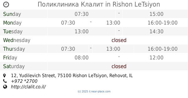
Clalit Pharmacy
Yudilevich Street 12, Rishon LeTsiyon
Pharmacy
read more
711 m
כללית - בית מרקחת
Yudilevich Street 12, Rishon LeTsiyon
Pharmacy
read more
711 m
כללית - בית מרקחת
יודיליביץ' 12, ראשון לציון
Pharmacy
read more
711 m
Поликлиника Клалит
Yudilevich Street 12, Rishon LeTsiyon
Pharmacy
read more
1.035 km
Поликлиника Клалит
David Wolffsohn Street 31, Rishon LeTsiyon
Pharmacy
read more
1.035 km
כללית בית מרקחת
David Wolffsohn Street 31, Rishon LeTsiyon
Pharmacy
read more
1.264 km
סופר פארם הרובע
דרך המכבים 16, ראשון לציון
Pharmacy
read more
1.499 km
Поликлиника Клалит
Pinsker Street 31, Rishon LeTsiyon
Pharmacy
read more
1.614 km
Maccabi Pharmacy
מרכז מסחרי נחלה, העצמאות 21, ראשון לציון
Pharmacy
read more
1.687 km
פארמה 10
ראשון לציון
Pharmacy
read more
1.758 km
Clalit Pharmacy
Sderot Ya'akov 50, Rishon LeTsiyon
Pharmacy
read more
1.758 km
Поликлиника Клалит
Sderot Ya'akov 50, Rishon LeTsiyon
Pharmacy
read more
📑
all categories
Accounting
Administrative area level 1
Administrative area level 2
Airport
Amusement park
Aquarium
Art gallery
Atm
Bakery
Bank
Bar
Beauty salon
Bicycle store
Book store
Bowling alley
Bus station
Cafe
Campground
Car dealer
Car rental
Car repair
Car wash
Casino
Cemetery
Church
City hall
Clothing store
Colloquial area
Convenience store
Country
Courthouse
Dentist
Department store
Doctor
Electrician
Electronics store
Embassy
Establishment
Finance
Fire station
Florist
Food
Funeral home
Furniture store
Gas station
General contractor
Grocery or supermarket
Gym
Hair care
Hardware store
Health
Hindu Temple
Home goods store
Hospital
Insurance agency
Intersection
Jewelry store
Laundry
Lawyer
Library
Light rail station
Liquor store
Local government office
Locality
Locksmith
Lodging
Meal delivery
Meal takeaway
Mosque
Movie rental
Movie theater
Moving company
Museum
Natural feature
Neighborhood
Night club
Painter
Park
Parking
Pet store
Pharmacy
Physiotherapist
Place of worship
Plumber
Point of interest
Police
Political
Post office
Premise
Real estate agency
Restaurant
Roofing contractor
Route
Rv park, camping
School
Shoe store
Shopping mall
Spa
Stadium
Storage
Store
Subpremise
Subway station
Supermarket
Synagogue
Taxi stand
Train station
Transit station
Travel agency
University
Veterinary care
Zoo
administrative area level 3
administrative area level 4
sublocality level 1
↑