Pharmacy nearby ניו פארם שוהם
Israel
Pharmacy nearby ניו פארם שוהם
ניו פארם שוהם
דקל 30, שוהם ישראל
contacts phone
:
+972
Latitude:
32.0065004
, Longitude:
34.9511782
read more
nearest Pharmacy
New Pharm
Dekel Street 30, Shoham
Pharmacy
read more
915 m
סופר פארם שוהם
מרכז מסחרי, עמק איילון 30, שוהם
Pharmacy
read more
915 m
Супер-Фарм
מרכז מסחרי, עמק איילון 30, שוהם
Pharmacy
read more
944 m
Clalit Pharmacy
Sderot Emek Ayalon 30, Shoham
Pharmacy
read more
1.18 km
ווו
פארק תעשיות חבל מודיעין, דרך החורש 23, Shoham
Pharmacy
read more
1.18 km
ווו
פארק תעשיות חבל מודיעין, דרך החורש 23, שוהם
Pharmacy
read more
4.213 km
סופר-פארם
Airport City
Pharmacy
read more
4.213 km
Super-Pharm
Airport City
Pharmacy
read more
4.213 km
Супер-Фарм
Airport City
Pharmacy
read more
4.252 km
סופר-פארם איירפורט-סיטי
קרית-שדה תעופה, Lod
Pharmacy
read more
5.032 km
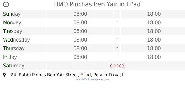
קופ"ח פינחס בן יאיר
רבי פנחס בן יאיר 24, אלעד
Pharmacy
read more
5.032 km
HMO Pinchas ben Yair
Rabbi Pinhas Ben Yair Street 24, El'ad
Pharmacy
read more
5.188 km
Shupersol Cosmos Yahud
Yehud
Pharmacy
read more
9.824 km
Meuhedet
הרבי מליובאוויטש 4, Kfar Habad
Pharmacy
read more
11.824 km
מכבי פארם
אבני נזר 46, מודיעין עילית
Pharmacy
read more
13.876 km
טבע הדברות
Halahav Street 2, Holon
Pharmacy
read more
14.876 km
כללית - בית מרקחת
דרך יצחק רבין 53, גבעתיים
Pharmacy
read more
15.442 km
Hertsel
Ramat Gan
Pharmacy
read more
15.697 km
Pharma Market
Raoul Wallenberg Street 18, Tel Aviv-Yafo
Pharmacy
read more
16.867 km
Поликлиника Клалит
Pinkhas Rosen Street 72, Tel Aviv-Yafo
Pharmacy
read more
16.875 km
Super-Pharm
Pinkhas Rosen Street 72, Tel Aviv-Yafo
Pharmacy
read more
16.948 km
S.r.m.farm Center
ויצמן 8, נס ציונה
Pharmacy
read more
17.307 km
Clalit
Palmakh Street 17, Rehovot
Pharmacy
read more
18.054 km
בית מרקחת מאוחדת
בנימין 7, רחובות
Pharmacy
read more
19.061 km
Aviv Afeka
Tel Aviv-Yafo
Pharmacy
read more
📑
all categories
Accounting
Administrative area level 1
Administrative area level 2
Airport
Amusement park
Aquarium
Art gallery
Atm
Bakery
Bank
Bar
Beauty salon
Bicycle store
Book store
Bowling alley
Bus station
Cafe
Campground
Car dealer
Car rental
Car repair
Car wash
Casino
Cemetery
Church
City hall
Clothing store
Colloquial area
Convenience store
Country
Courthouse
Dentist
Department store
Doctor
Electrician
Electronics store
Embassy
Establishment
Finance
Fire station
Florist
Food
Funeral home
Furniture store
Gas station
General contractor
Grocery or supermarket
Gym
Hair care
Hardware store
Health
Hindu Temple
Home goods store
Hospital
Insurance agency
Intersection
Jewelry store
Laundry
Lawyer
Library
Light rail station
Liquor store
Local government office
Locality
Locksmith
Lodging
Meal delivery
Meal takeaway
Mosque
Movie rental
Movie theater
Moving company
Museum
Natural feature
Neighborhood
Night club
Painter
Park
Parking
Pet store
Pharmacy
Physiotherapist
Place of worship
Plumber
Point of interest
Police
Political
Post office
Premise
Real estate agency
Restaurant
Roofing contractor
Route
Rv park, camping
School
Shoe store
Shopping mall
Spa
Stadium
Storage
Store
Subpremise
Subway station
Supermarket
Synagogue
Taxi stand
Train station
Transit station
Travel agency
University
Veterinary care
Zoo
administrative area level 3
administrative area level 4
sublocality level 1
↑