Pharmacy nearby Hussein Pharmacy
Israel
Pharmacy nearby Hussein Pharmacy
Hussein Pharmacy
Main Street
contacts phone
:
+972
Latitude:
32.4115313
, Longitude:
35.2825625
larger map & directions
read more
nearest Pharmacy
5.056 km
صيدلية الجامعة
Main Street, Zababdeh
Pharmacy
read more
5.603 km
Al Barakah Pharmacy | صيدلية البركة
AAUJ street, Jenin
Pharmacy
read more
5.727 km
صيدلية البراء
فلسطين, عمان, الأردن
Pharmacy
read more
5.766 km
صيدلية صلاح
2 5، Tel Aviv-Yafo
Pharmacy
read more
5.904 km
Al-Rahma Pharmacy
Palestine
Pharmacy
read more
8.141 km
صيدليه حنين
Main Street
Pharmacy
read more
8.685 km
صيدليه الجديدة
Main Street
Pharmacy
read more
13.838 km
נקודת הזנקה מדא גן נר
Gan Ner
Pharmacy
read more
13.838 km
נקודת הזנקה מדא גן נר
גן נר
Pharmacy
read more
16.198 km
דר פארם
عز الدين القسام أم الفحم IL 30010, עז א דין אל קסאם, אום אל-פחם
Pharmacy
read more
16.204 km
بناشر فرج
אום אל-פחם
Pharmacy
read more
16.425 km
Поликлиника Клалит
אום אל פחם - שכ' אלמלסא, Umm al-Fahm
Pharmacy
read more
16.425 km
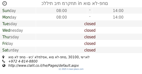
כללית בית מרקחת
אום אל פחם - שכ' אלמלסא, אום אל-פחם
Pharmacy
read more
16.741 km
בית מרקחת אלמג'ד صيدلية المجد
כיכר השגור עין גראר, Umm al-Fahm
Pharmacy
read more
16.741 km
בית מרקחת אלמג'ד صيدلية المجد
כיכר השגור עין גראר, אום אל-פחם
Pharmacy
read more
16.888 km
בית מרקחת דיווה פארם
ג'דוע תחתון, אום אל-פחם
Pharmacy
read more
16.888 km
Diva Pharm pharmacy
Jadu' Takhton Street, Umm al-Fahm
Pharmacy
read more
17.242 km
-בית מרקחת מרים
Ali Ben Abi Taleb Street, Umm al-Fahm
Pharmacy
read more
17.401 km
Ibn Sina Pharmacy - Masoud
שכונת מחאג׳נה אל שיכון ליד בית ספר אבן סינא, Ibn Sina Street, Umm al-Fahm
Pharmacy
read more
18.091 km
בסמאן פארם אלשאגור מרכז
מרכז אלשאגור, אום אל-פחם
Pharmacy
read more
18.223 km
Pharmacy ONE
El-Madina Street 58, Umm al-Fahm
Pharmacy
read more
18.223 km
בית מרקחת ONE
אל מדינה 58, אום אל-פחם
Pharmacy
read more
18.233 km
חכמה
אום אל-פחם
Pharmacy
read more
18.233 km
Huchma
Umm al-Fahm
Pharmacy
read more
18.618 km
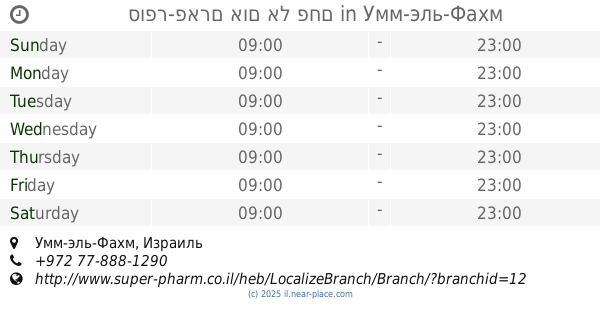
סופר-פארם אום אל פחם
Umm al-Fahm
Pharmacy
read more
📑
all categories
Accounting
Administrative area level 1
Administrative area level 2
Airport
Amusement park
Aquarium
Art gallery
Atm
Bakery
Bank
Bar
Beauty salon
Bicycle store
Book store
Bowling alley
Bus station
Cafe
Campground
Car dealer
Car rental
Car repair
Car wash
Casino
Cemetery
Church
City hall
Clothing store
Colloquial area
Convenience store
Country
Courthouse
Dentist
Department store
Doctor
Electrician
Electronics store
Embassy
Establishment
Finance
Fire station
Florist
Food
Funeral home
Furniture store
Gas station
General contractor
Grocery or supermarket
Gym
Hair care
Hardware store
Health
Hindu Temple
Home goods store
Hospital
Insurance agency
Intersection
Jewelry store
Laundry
Lawyer
Library
Light rail station
Liquor store
Local government office
Locality
Locksmith
Lodging
Meal delivery
Meal takeaway
Mosque
Movie rental
Movie theater
Moving company
Museum
Natural feature
Neighborhood
Night club
Painter
Park
Parking
Pet store
Pharmacy
Physiotherapist
Place of worship
Plumber
Point of interest
Police
Political
Post office
Premise
Real estate agency
Restaurant
Roofing contractor
Route
Rv park, camping
School
Shoe store
Shopping mall
Spa
Stadium
Storage
Store
Subpremise
Subway station
Supermarket
Synagogue
Taxi stand
Train station
Transit station
Travel agency
University
Veterinary care
Zoo
administrative area level 3
administrative area level 4
sublocality level 1
↑