Pharmacy nearby صيدليه حنين
Israel
Pharmacy nearby صيدليه حنين
صيدليه حنين
Main Street Israel
contacts phone
:
+972
Latitude:
32.3404246
, Longitude:
35.3032377
read more
nearest Pharmacy
652 m
صيدليه الجديدة
Main Street
Pharmacy
read more
5.309 km
صيدلية الجامعة
Main Street, Zababdeh
Pharmacy
read more
8.056 km
Al Barakah Pharmacy | صيدلية البركة
AAUJ street, Jenin
Pharmacy
read more
13.436 km
صيدلية صلاح
2 5، Tel Aviv-Yafo
Pharmacy
read more
13.503 km
صيدلية البراء
فلسطين, عمان, الأردن
Pharmacy
read more
13.615 km
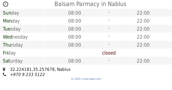
Balsam Parmacy
32.224181,35.257678
Pharmacy
read more
13.642 km
Al-Rahma Pharmacy
Palestine
Pharmacy
read more
13.651 km
Future pharmacy
Asker Main Street، نابلس
Pharmacy
read more
13.681 km
Sabri Pharmacy
32.22465,35.253809
Pharmacy
read more
13.715 km
صيدلية الاحسان
32.224211,35.254271
Pharmacy
read more
13.761 km
Ibn Sina Pharmacy
Nablus
Pharmacy
read more
13.772 km
Sana Pharmacy
Ibn Sina
Pharmacy
read more
13.785 km
Perfect Pharmacy
Pharmacy
read more
13.829 km
Shakhshir Pharmacy
32.221532,35.259781
Pharmacy
read more
13.845 km
Waleed Pharmacy
32.221524,35.259336
Pharmacy
read more
13.854 km
Hassan Pharmacy
Pharmacy
read more
13.863 km
Aslan Pharmacy
32.221064,35.260503
Pharmacy
read more
13.891 km
Fawaz Pharmacy
9، Hadera
Pharmacy
read more
13.894 km
Anaam Pharmacy
32.221005,35.259669
Pharmacy
read more
13.904 km
Qaderi Pharmacy
32.22425,35.248367
Pharmacy
read more
13.916 km
Khurshid Pharmacy
32.221137,35.258283
Pharmacy
read more
13.959 km
صيدلية تبارك
32.22468,35.245648
Pharmacy
read more
14.18 km
Nour alyousef pharmacy
An Najah old campus street Nablus
Pharmacy
read more
14.356 km
Al-Fayhaa' Pharmacy
شارع عمر بن الخطاب ،محافظة نابلس ، نابلس Nablus
Pharmacy
read more
14.555 km
صيدلية نغم
Pharmacy
read more
📑
all categories
Accounting
Administrative area level 1
Administrative area level 2
Airport
Amusement park
Aquarium
Art gallery
Atm
Bakery
Bank
Bar
Beauty salon
Bicycle store
Book store
Bowling alley
Bus station
Cafe
Campground
Car dealer
Car rental
Car repair
Car wash
Casino
Cemetery
Church
City hall
Clothing store
Colloquial area
Convenience store
Country
Courthouse
Dentist
Department store
Doctor
Electrician
Electronics store
Embassy
Establishment
Finance
Fire station
Florist
Food
Funeral home
Furniture store
Gas station
General contractor
Grocery or supermarket
Gym
Hair care
Hardware store
Health
Hindu Temple
Home goods store
Hospital
Insurance agency
Intersection
Jewelry store
Laundry
Lawyer
Library
Light rail station
Liquor store
Local government office
Locality
Locksmith
Lodging
Meal delivery
Meal takeaway
Mosque
Movie rental
Movie theater
Moving company
Museum
Natural feature
Neighborhood
Night club
Painter
Park
Parking
Pet store
Pharmacy
Physiotherapist
Place of worship
Plumber
Point of interest
Police
Political
Post office
Premise
Real estate agency
Restaurant
Roofing contractor
Route
Rv park, camping
School
Shoe store
Shopping mall
Spa
Stadium
Storage
Store
Subpremise
Subway station
Supermarket
Synagogue
Taxi stand
Train station
Transit station
Travel agency
University
Veterinary care
Zoo
administrative area level 3
administrative area level 4
sublocality level 1
↑