Lodging nearby אירוח רוקנשטין - אחוזת נופש בהר כנען
Israel
Lodging nearby אירוח רוקנשטין - אחוזת נופש בהר כנען
אירוח רוקנשטין - אחוזת נופש בהר כנען
ביריה, ישראל
contacts phone
:
+972
website:
my.weekend.co.il
Latitude:
32.978108
, Longitude:
35.503096
larger map & directions
read more
nearest Lodging
צימר אילי
ביריה
Lodging
read more
16 m
Beit Romano
ביריה, Birya
Lodging
read more
16 m
בית רומנו
ביריה
Lodging
read more
338 m
קסם היער ביריה
12, ביריה
Lodging
read more
338 m
קסם היער ביריה
12, Birya
Lodging
read more
392 m
Canaan Spa Hotel
Ha-Gdud ha-Shlishi Street 106, Safed
Lodging
read more
402 m
Soka in the Galilee
Safed
Lodging
read more
408 m
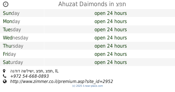
אחוזת דיימונדס
הגדוד השלישי, צפת
Lodging
read more
452 m
אחוזת אבן ספיר
הגדוד השלישי, צפת
Lodging
read more
584 m
Ahuzat Daimonds
הגדוד השלישי, צפת
Lodging
read more
585 m
וילה גליליי מלון בוטיק וספא בצפון
הגדוד השלישי 106, Safed
Lodging
read more
629 m
Achuza Bamarom
Avraam Ha Cohen, 53, Safed
Lodging
read more
675 m
אחוזה שויצרית פוסטורלית
Me'ir Meivar Street, Safed
Lodging
read more
682 m
Safed Inn
Ha-Gdud ha-Shlishi St, Safed
Lodging
read more
727 m
וילה שרה
מאיר מיבר, צפת
Lodging
read more
958 m
Avira D'Tzfat-Kosher,Dati
71 1321171, Yud Alph Street, Safed
Lodging
read more
1.15 km
A Little Galilee House
Zamir Street 467/2, Safed
Lodging
read more
1.167 km
פנינת חן
רדב"ז 11, צפת
Lodging
read more
1.167 km
Pninat Chen
רדב"ז 11, Safed
Lodging
read more
1.167 km
Hotel Carmel
HaAri Street 8, Safed
Lodging
read more
1.174 km
Ascent of Tzfat
האר"י 2, צפת
Lodging
read more
1.182 km
אסנט
האר"י 2, צפת
Lodging
read more
1.256 km
Zimmer nobility sky
Jerusalem Street 24, Safed
Lodging
read more
1.315 km
מרכזי
צפת
Lodging
read more
1.318 km
מלון המצודה
ירושלים 37, צפת
Lodging
read more
📑
all categories
Accounting
Administrative area level 1
Administrative area level 2
Airport
Amusement park
Aquarium
Art gallery
Atm
Bakery
Bank
Bar
Beauty salon
Bicycle store
Book store
Bowling alley
Bus station
Cafe
Campground
Car dealer
Car rental
Car repair
Car wash
Casino
Cemetery
Church
City hall
Clothing store
Colloquial area
Convenience store
Country
Courthouse
Dentist
Department store
Doctor
Electrician
Electronics store
Embassy
Establishment
Finance
Fire station
Florist
Food
Funeral home
Furniture store
Gas station
General contractor
Grocery or supermarket
Gym
Hair care
Hardware store
Health
Hindu Temple
Home goods store
Hospital
Insurance agency
Intersection
Jewelry store
Laundry
Lawyer
Library
Light rail station
Liquor store
Local government office
Locality
Locksmith
Lodging
Meal delivery
Meal takeaway
Mosque
Movie rental
Movie theater
Moving company
Museum
Natural feature
Neighborhood
Night club
Painter
Park
Parking
Pet store
Pharmacy
Physiotherapist
Place of worship
Plumber
Point of interest
Police
Political
Post office
Premise
Real estate agency
Restaurant
Roofing contractor
Route
Rv park, camping
School
Shoe store
Shopping mall
Spa
Stadium
Storage
Store
Subpremise
Subway station
Supermarket
Synagogue
Taxi stand
Train station
Transit station
Travel agency
University
Veterinary care
Zoo
administrative area level 3
administrative area level 4
sublocality level 1
↑