Lodging nearby Achuza Bamarom
Israel
Lodging nearby Achuza Bamarom
Achuza Bamarom
Avraam Ha Cohen, 53, Safed Израиль
contacts phone
:
+972
Latitude:
32.973988
, Longitude:
35.507717
read more
nearest Lodging
137 m
Villa Galilee
Ha-Gdud ha-Shlishi Street 106, Safed
Spa
Lodging
Point of interest
Establishment
read more
157 m
Villa Galilee Boutique Hotel and Spa
Ha' Gdud Ha' Shlishi, 106, Safed
Lodging
read more
163 m
וילה גליליי מלון בוטיק וספא בצפון
הגדוד השלישי 106, Safed
Lodging
read more
177 m
אחוזת אבן ספיר
הגדוד השלישי, צפת
Lodging
read more
185 m
On the Edge of the Cliff - religious hosting
Bareket Street 8, Safed
Lodging
read more
202 m
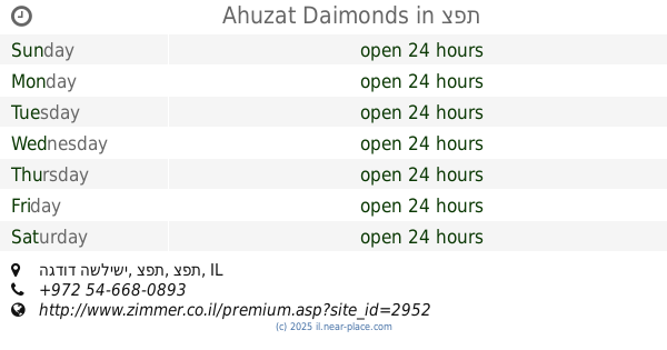
Ahuzat Daimonds
הגדוד השלישי, צפת
Lodging
read more
211 m
וילה שרה
מאיר מיבר, צפת
Lodging
read more
239 m
אחוזת דיימונדס
הגדוד השלישי, צפת
Lodging
read more
291 m
אחוזה שויצרית פוסטורלית
Me'ir Meivar Street, Safed
Lodging
read more
395 m
Canaan Spa Hotel Safed
מלון ספא כנען, Safed
Lodging
read more
395 m
Canaan Spa Hotel
Ha-Gdud ha-Shlishi Street 106, Safed
Lodging
read more
571 m
Soka in the Galilee
Safed
Lodging
read more
629 m
צימר אילי
ביריה
Lodging
read more
629 m
אירוח רוקנשטין - אחוזת נופש בהר כנען
ביריה
Lodging
read more
641 m
Beit Romano
ביריה, Birya
Lodging
read more
641 m
בית רומנו
ביריה
Lodging
read more
788 m
Safed Inn
Ha-Gdud ha-Shlishi St, Safed
Lodging
read more
805 m
ארצפת
אודם10 צפת, צפת
Lodging
read more
957 m
קסם היער ביריה
12, Birya
Lodging
read more
957 m
קסם היער ביריה
12, ביריה
Lodging
read more
1.008 km
Safed Kinneret View Apartment
Kaf Bet Yeldei Maalot 261/2, Safed 1323204
Lodging
read more
1.037 km
Avira D'Tzfat-Kosher,Dati
71 1321171, Yud Alph Street, Safed
Lodging
read more
1.058 km
אצולת נתנאל
Har Adir Street 9, Safed
Lodging
read more
1.096 km
בית ארז אירוח יהודי
הר כנען, יעקב הופרט, צפת
Lodging
read more
1.096 km
Hess דירות יוקרה
הר כנען, צפת
Lodging
read more
📑
all categories
Accounting
Administrative area level 1
Administrative area level 2
Airport
Amusement park
Aquarium
Art gallery
Atm
Bakery
Bank
Bar
Beauty salon
Bicycle store
Book store
Bowling alley
Bus station
Cafe
Campground
Car dealer
Car rental
Car repair
Car wash
Casino
Cemetery
Church
City hall
Clothing store
Colloquial area
Convenience store
Country
Courthouse
Dentist
Department store
Doctor
Electrician
Electronics store
Embassy
Establishment
Finance
Fire station
Florist
Food
Funeral home
Furniture store
Gas station
General contractor
Grocery or supermarket
Gym
Hair care
Hardware store
Health
Hindu Temple
Home goods store
Hospital
Insurance agency
Intersection
Jewelry store
Laundry
Lawyer
Library
Light rail station
Liquor store
Local government office
Locality
Locksmith
Lodging
Meal delivery
Meal takeaway
Mosque
Movie rental
Movie theater
Moving company
Museum
Natural feature
Neighborhood
Night club
Painter
Park
Parking
Pet store
Pharmacy
Physiotherapist
Place of worship
Plumber
Point of interest
Police
Political
Post office
Premise
Real estate agency
Restaurant
Roofing contractor
Route
Rv park, camping
School
Shoe store
Shopping mall
Spa
Stadium
Storage
Store
Subpremise
Subway station
Supermarket
Synagogue
Taxi stand
Train station
Transit station
Travel agency
University
Veterinary care
Zoo
administrative area level 3
administrative area level 4
sublocality level 1
↑