Gas station nearby תחנת דלק יעד
Israel
Gas station nearby תחנת דלק יעד
תחנת דלק יעד
26, דרך יצחק רבין, נס ציונה, רחובות, IL ישראל
contacts phone
:
+972
website:
www.yaadfuel.co.il
Latitude:
31.9226582
, Longitude:
34.7860371
larger map & directions
read more
nearest Gas station
480 m
סונול פאוור סנטר
פאואר סנטר, האיזמל 1, נס ציונה
Gas station
read more
1.148 km
דלק
Ness Ziona
Gas station
read more
1.148 km
דלק
נס ציונה
Gas station
read more
1.338 km
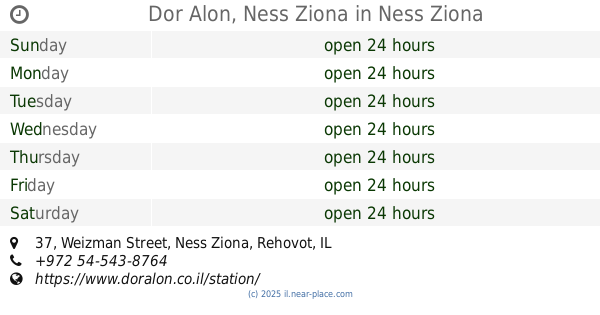
Dor Alon, Ness Ziona
Weizman Street 37, Ness Ziona
Gas station
read more
1.338 km
Dor Alon
Weizman Street 37, Ness Ziona
Gas station
read more
1.708 km
תחנת דלק אברך אלון למנויים
בית חנן
Gas station
read more
1.708 km
תחנת דלק אברך אלון למנויים
Beit Hanan
Gas station
read more
2.029 km
תחנת דלק סונול
המדע קריית המדע, רחובות
Gas station
read more
2.037 km
Grill Hamada
Rehovot
Gas station
read more
2.333 km
Dor Alon Science Park
Prof. Hillel ve-Khanan Oppenheimer Street 10, Rehovot
Gas station
read more
2.333 km
דור אלון פארק המדע
פרופ' הלל וחנן אופנהיימר 10, רחובות
Gas station
read more
2.537 km
Dor Alon Gas Station
רחובות
Gas station
read more
2.537 km
Dor Alon Gas Station
Rehovot
Gas station
read more
2.823 km
פז מנחם
כביש ראשון לציון נס ציונה, נס ציונה
Gas station
read more
2.893 km
Paz
Herzl Street 223, Rehovot
Gas station
read more
2.893 km
פז יד ויצמן
הרצל 223, רחובות
Gas station
read more
3.085 km
סונול עטרת
Herzl Street 151, Rishon LeTsiyon
Gas station
read more
3.085 km
Sonol Ateret
Herzl Street 151, Rishon LeTsiyon
Gas station
read more
3.085 km
סונול עטרת
הרצל 151, ראשון לציון
Gas station
read more
3.085 km
Сонол
Herzl Street 151, Rishon LeTsiyon
Gas station
read more
3.75 km
פז רכטמן רחובות
א"ת רכטמן, קלמן גבריאלוב פינת היצירה, רחובות
Gas station
read more
3.964 km
פז גילי
קלמר, Kalman Shor Street, Rishon LeTsiyon
Gas station
read more
3.964 km
פז גילי
קלמר, קלמן שור, ראשון לציון
Gas station
read more
4.965 km
תחנת דלק טן
הרצל 79, ראשון לציון
Gas station
read more
5.583 km
דלק טן
Yavne
Gas station
read more
📑
all categories
Accounting
Administrative area level 1
Administrative area level 2
Airport
Amusement park
Aquarium
Art gallery
Atm
Bakery
Bank
Bar
Beauty salon
Bicycle store
Book store
Bowling alley
Bus station
Cafe
Campground
Car dealer
Car rental
Car repair
Car wash
Casino
Cemetery
Church
City hall
Clothing store
Colloquial area
Convenience store
Country
Courthouse
Dentist
Department store
Doctor
Electrician
Electronics store
Embassy
Establishment
Finance
Fire station
Florist
Food
Funeral home
Furniture store
Gas station
General contractor
Grocery or supermarket
Gym
Hair care
Hardware store
Health
Hindu Temple
Home goods store
Hospital
Insurance agency
Intersection
Jewelry store
Laundry
Lawyer
Library
Light rail station
Liquor store
Local government office
Locality
Locksmith
Lodging
Meal delivery
Meal takeaway
Mosque
Movie rental
Movie theater
Moving company
Museum
Natural feature
Neighborhood
Night club
Painter
Park
Parking
Pet store
Pharmacy
Physiotherapist
Place of worship
Plumber
Point of interest
Police
Political
Post office
Premise
Real estate agency
Restaurant
Roofing contractor
Route
Rv park, camping
School
Shoe store
Shopping mall
Spa
Stadium
Storage
Store
Subpremise
Subway station
Supermarket
Synagogue
Taxi stand
Train station
Transit station
Travel agency
University
Veterinary care
Zoo
administrative area level 3
administrative area level 4
sublocality level 1
↑