Cafe nearby Abu Jaber Cafe
Israel
Cafe nearby Abu Jaber Cafe
Abu Jaber Cafe
Нейблус
contacts phone
:
+972
Latitude:
32.216206
, Longitude:
35.271781
larger map & directions
read more
nearest Cafe
36 m
Crystal - Zinada Cafe
El-Horeya
Cafe
read more
1.156 km
Stars & Bucks Cafe
Nablus
Cafe
read more
1.355 km
مقهى وكوفي شوب السلطان
Palestine Road
Cafe
read more
1.414 km
كوفي شوب قصر النيل
Nablus
Cafe
read more
1.556 km
Alhmuz cafe
شارع الشويتره
Cafe
read more
2.919 km
منتزة الحرية
Al-Madares Street
Cafe
read more
3.641 km
7Nero Cafe & Gelato
Rafidia, Nablus
Cafe
read more
3.832 km
Coffe And Cake
asim sawalmeh
Cafe
read more
3.857 km
Cafe Abu Laith
عصيره الشماليه مقهى ابو ليث
Cafe
read more
3.866 km
قهوة قتيبة (Cafe)
شارع مدرسة بنات عصيرة الاساسية
Cafe
read more
3.905 km
قهوة فايز سوالمه (Cafe)
المسبغة (وسط البلد, المصبغة الخضراء, Damascus
Cafe
read more
4.038 km
مقهى الشمال
مقهى الشمال -ديسكو
Cafe
read more
4.116 km
كزدورة corn&more
Ervadi
Cafe
read more
4.138 km
مقهى الفارس
Al Madrab
Cafe
read more
10.205 km
איילה פשוט טעים
גבעת שלם, קדומים
Cafe
read more
11.161 km
Good coffee
רימון 3, כפר תפוח
Cafe
read more
11.161 km
קפה טוב
רימון 3, כפר תפוח
Cafe
read more
14.072 km
مقهى واستراحه الكينا
Jenin, Judida
Cafe
read more
14.286 km
דלי קרים
דרך הציונות 56, אריאל
Cafe
read more
15.004 km
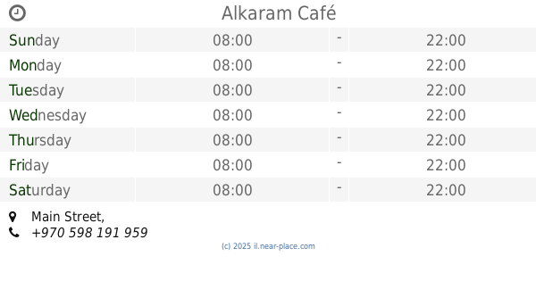
Alkaram Café
Main Street
Cafe
read more
24.096 km
زيزو-نت كافية
شارع العزبة, طولكرم
Cafe
Food
Point of interest
Store
Establishment
read more
25.045 km
Cafe In
Tayibe
Cafe
read more
25.187 km
עוד סעיד
טייבה
Cafe
read more
25.896 km
Laymuna Cafè
شارع يافا، طولكرم
Cafe
read more
28.255 km
המקום לאדם לאדמה
שקד פינת אלמוגן, בחן
Cafe
read more
📑
all categories
Accounting
Administrative area level 1
Administrative area level 2
Airport
Amusement park
Aquarium
Art gallery
Atm
Bakery
Bank
Bar
Beauty salon
Bicycle store
Book store
Bowling alley
Bus station
Cafe
Campground
Car dealer
Car rental
Car repair
Car wash
Casino
Cemetery
Church
City hall
Clothing store
Colloquial area
Convenience store
Country
Courthouse
Dentist
Department store
Doctor
Electrician
Electronics store
Embassy
Establishment
Finance
Fire station
Florist
Food
Funeral home
Furniture store
Gas station
General contractor
Grocery or supermarket
Gym
Hair care
Hardware store
Health
Hindu Temple
Home goods store
Hospital
Insurance agency
Intersection
Jewelry store
Laundry
Lawyer
Library
Light rail station
Liquor store
Local government office
Locality
Locksmith
Lodging
Meal delivery
Meal takeaway
Mosque
Movie rental
Movie theater
Moving company
Museum
Natural feature
Neighborhood
Night club
Painter
Park
Parking
Pet store
Pharmacy
Physiotherapist
Place of worship
Plumber
Point of interest
Police
Political
Post office
Premise
Real estate agency
Restaurant
Roofing contractor
Route
Rv park, camping
School
Shoe store
Shopping mall
Spa
Stadium
Storage
Store
Subpremise
Subway station
Supermarket
Synagogue
Taxi stand
Train station
Transit station
Travel agency
University
Veterinary care
Zoo
administrative area level 3
administrative area level 4
sublocality level 1
↑