Cafe nearby איילה פשוט טעים
Israel
Cafe nearby איילה פשוט טעים
איילה פשוט טעים
גבעת שלם, קדומים
contacts phone
:
+972 54-747-4764
Latitude:
32.225268
, Longitude:
35.163818
larger map & directions
read more
nearest Cafe
9.137 km
كوفي شوب قصر النيل
Nablus
Cafe
read more
10.077 km
قهوة قتيبة (Cafe)
شارع مدرسة بنات عصيرة الاساسية
Cafe
read more
10.305 km
Coffe And Cake
asim sawalmeh
Cafe
read more
10.532 km
مقهى الشمال
مقهى الشمال -ديسكو
Cafe
read more
12.849 km
منتزة الحرية
Al-Madares Street
Cafe
read more
13.39 km
דלי קרים
דרך הציונות 56, אריאל
Cafe
read more
14.518 km
Good coffee
רימון 3, כפר תפוח
Cafe
read more
14.677 km
Cafe sentenced
8393+PM8, Nablus Street, Amman
Cafe
Food
Point of interest
Establishment
read more
14.677 km
Cafe sentenced
Nablus Street, Amman
Cafe
read more
14.719 km
زيزو-نت كافية
شارع العزبة, طولكرم
Cafe
Food
Point of interest
Store
Establishment
read more
15.022 km
Cafe In
Tayibe
Cafe
read more
15.166 km
קפה אלחמאם
Unnamed Road, Tayibe
Cafe
Food
Point of interest
Store
Establishment
read more
15.177 km
עוד סעיד
טייבה
Cafe
read more
15.214 km
مقصف كان زمان
24, ת.ד 4399, Taibe
Cafe
Store
Food
Point of interest
Establishment
read more
15.215 km
Cafe In
11, Taibe
Cafe
Food
Point of interest
Establishment
read more
15.332 km
Cafe Sucre
,כניסה צפונית, Tayibe
Cafe
read more
15.781 km
בית קפה נרגילה
חסן מוסא, טייבה
Cafe
read more
15.842 km
CafeIN
444, Taibe
Cafe
Food
Point of interest
Establishment
read more
16.13 km
Gala
828J+WF7, Alquds open University street, طولكرم
Cafe
Food
Point of interest
Establishment
read more
16.252 km
مطاحن بريك
دوار شويكة
Cafe
read more
16.531 km
Laymuna Cafè
شارع يافا، طولكرم
Cafe
read more
17.37 km
ימינ'ס
Ha-Shlosha Street 3, Nitzanei Oz
Cafe
Food
Point of interest
Store
Establishment
read more
19.719 km
המקום לאדם לאדמה
שקד פינת אלמוגן, בחן
Cafe
read more
19.801 km
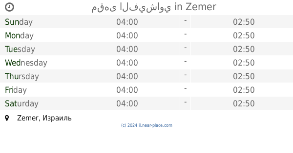
مقهى الفيشاوي
זמר
Cafe
read more
19.801 km
مقهى الفيشاوي
Zemer
Cafe
read more
📑
all categories
Accounting
Administrative area level 1
Administrative area level 2
Airport
Amusement park
Aquarium
Art gallery
Atm
Bakery
Bank
Bar
Beauty salon
Bicycle store
Book store
Bowling alley
Bus station
Cafe
Campground
Car dealer
Car rental
Car repair
Car wash
Casino
Cemetery
Church
City hall
Clothing store
Colloquial area
Convenience store
Country
Courthouse
Dentist
Department store
Doctor
Electrician
Electronics store
Embassy
Establishment
Finance
Fire station
Florist
Food
Funeral home
Furniture store
Gas station
General contractor
Grocery or supermarket
Gym
Hair care
Hardware store
Health
Hindu Temple
Home goods store
Hospital
Insurance agency
Intersection
Jewelry store
Laundry
Lawyer
Library
Light rail station
Liquor store
Local government office
Locality
Locksmith
Lodging
Meal delivery
Meal takeaway
Mosque
Movie rental
Movie theater
Moving company
Museum
Natural feature
Neighborhood
Night club
Painter
Park
Parking
Pet store
Pharmacy
Physiotherapist
Place of worship
Plumber
Point of interest
Police
Political
Post office
Premise
Real estate agency
Restaurant
Roofing contractor
Route
Rv park, camping
School
Shoe store
Shopping mall
Spa
Stadium
Storage
Store
Subpremise
Subway station
Supermarket
Synagogue
Taxi stand
Train station
Transit station
Travel agency
University
Veterinary care
Zoo
administrative area level 3
administrative area level 4
sublocality level 1
↑