Bar nearby Rewined M&D
Israel
Bar nearby Rewined M&D
Rewined M&D
Manger Street Bethlehem
contacts phone
:
+970 598 583 017
website:
www.facebook.com
Latitude:
31.713724
, Longitude:
35.202731
larger map & directions
read more
nearest Bar
621 m
The Walled Off Hotel
Caritas Street 182, بيت لحم
Art gallery
Museum
Lodging
Bar
Restaurant
Food
Point of interest
Establishment
read more
1.054 km
Taboo Burger Bar
Al-Sahel Street / Normandi Square، Beit Jala
Bar
read more
1.528 km
Delight
Virgin mary street, Beit jala
Cafe
Bar
Food
Point of interest
Establishment
read more
1.658 km
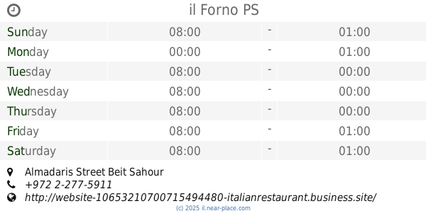
il Forno
Almadaris Street Beit Sahour
Bar
read more
2.445 km
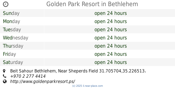
Golden Park Resort
Beit Sahour Bethlehem, Near Sheperds Field 31.705704,35.226513, Bethlehem
Bar
read more
2.686 km
SOUL
198, Shepherds Field, Martyr Worthy
Bar
read more
4.338 km
City Park Bar
HaTnufa Street 10, Jerusalem
Bar
read more
4.559 km
החלונות הגבוהים - ירושלים
פועלי צדק, ירושלים
Bar
read more
6.005 km
פאב המפלצת - Hamiflezet pub
Chile Street 8, Jerusalem
Bar
read more
6.548 km
באב אל ימן
דרך עזה 29, ירושלים
Bar
read more
7.236 km
זוטא - בר קוקטיילים
King David 10, Jerusalem
Bar
read more
7.48 km
Focaccia Bar
4 94582, Rabbi Akiva Street, Jerusalem
Bar
read more
7.522 km
The Sira Pub
Ben Sira Street 4, Jerusalem
Bar
read more
7.552 km
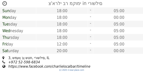
צ'ארלי בר מקומי
שמעון בן שטח 3, ירושלים
Bar
read more
7.554 km
Shoshana Bar
שושן 7, ירושלים
Bar
read more
7.597 km
Blue Hall Music (בלו הול מיוסיק)
יואל משה סלומון 12, ירושלים
Bar
read more
7.615 km
solo bar & Restaurant
Yosef Rivlin Street, Jerusalem
Bar
read more
7.638 km
גואה בר
יואל משה סלומון 15, ירושלים
Bar
read more
7.649 km
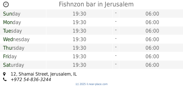
Fishnzon bar
Shamai Street 12, Jerusalem
Bar
read more
7.911 km
אוקונול בשוק
עץ חיים 69, ירושלים
Bar
read more
8.01 km
time bar & coffee
ירושלים
Bar
read more
8.042 km
קזינו דה פריז
מחנה יהודה 3, ירושלים
Bar
read more
8.085 km
English cake
Beit Ha-Defus Street 7, Jerusalem
Bar
read more
8.085 km
אינגליש קייק
בית הדפוס 7, ירושלים
Bar
read more
15.963 km
הרצל
Morad Nakhal Prat Street, Almon
Bar
read more
📑
all categories
Accounting
Administrative area level 1
Administrative area level 2
Airport
Amusement park
Aquarium
Art gallery
Atm
Bakery
Bank
Bar
Beauty salon
Bicycle store
Book store
Bowling alley
Bus station
Cafe
Campground
Car dealer
Car rental
Car repair
Car wash
Casino
Cemetery
Church
City hall
Clothing store
Colloquial area
Convenience store
Country
Courthouse
Dentist
Department store
Doctor
Electrician
Electronics store
Embassy
Establishment
Finance
Fire station
Florist
Food
Funeral home
Furniture store
Gas station
General contractor
Grocery or supermarket
Gym
Hair care
Hardware store
Health
Hindu Temple
Home goods store
Hospital
Insurance agency
Intersection
Jewelry store
Laundry
Lawyer
Library
Light rail station
Liquor store
Local government office
Locality
Locksmith
Lodging
Meal delivery
Meal takeaway
Mosque
Movie rental
Movie theater
Moving company
Museum
Natural feature
Neighborhood
Night club
Painter
Park
Parking
Pet store
Pharmacy
Physiotherapist
Place of worship
Plumber
Point of interest
Police
Political
Post office
Premise
Real estate agency
Restaurant
Roofing contractor
Route
Rv park, camping
School
Shoe store
Shopping mall
Spa
Stadium
Storage
Store
Subpremise
Subway station
Supermarket
Synagogue
Taxi stand
Train station
Transit station
Travel agency
University
Veterinary care
Zoo
administrative area level 3
administrative area level 4
sublocality level 1
↑