Bar nearby הרצל
Israel
Bar nearby הרצל
הרצל
Morad Nakhal Prat Street, Almon
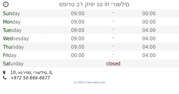
contacts phone
:
+972
Latitude:
31.832523
, Longitude:
35.2975736
larger map & directions
read more
nearest Bar
4.232 km
חאן ענבלים
חאן ענבלים, ארז, מעלה מחמש
Bar
read more
4.232 km
Khan clappers
חאן ענבלים, Erez, מעלה מחמש
Bar
read more
9.135 km
Shoshana Bar
שושן 7, ירושלים
Bar
read more
9.276 km
Zabotinski bar
Jerusalem
Bar
read more
9.276 km
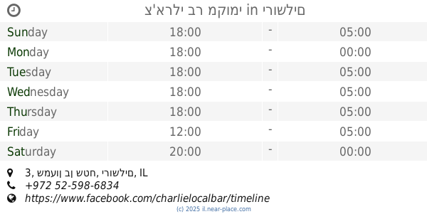
צ'ארלי בר מקומי
שמעון בן שטח 3, ירושלים
Bar
read more
9.285 km
The Sira Pub
Ben Sira Street 4, Jerusalem
Bar
read more
9.296 km
בל ווד בר
יוסף ריבלין 5, ירושלים
Bar
read more
9.306 km
solo bar & Restaurant
Yosef Rivlin Street, Jerusalem
Bar
read more
9.327 km
גואה בר
יואל משה סלומון 15, ירושלים
Bar
read more
9.357 km
Blue Hall Music (בלו הול מיוסיק)
יואל משה סלומון 12, ירושלים
Bar
read more
9.378 km
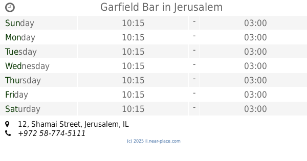
Garfield Bar
Shamai Street 12, Jerusalem
Bar
read more
9.39 km
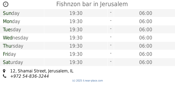
Fishnzon bar
Shamai Street 12, Jerusalem
Bar
read more
9.409 km
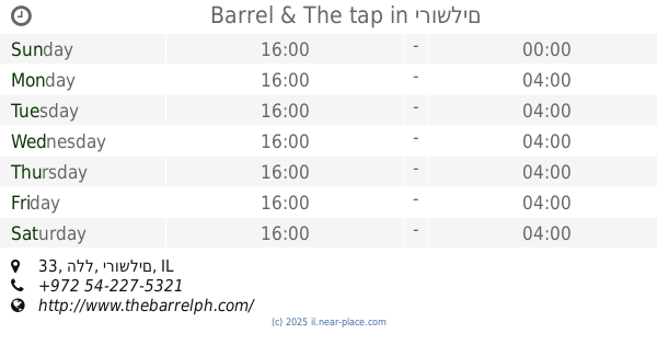
Barrel & The tap
הלל 33, ירושלים
Bar
read more
9.42 km
ספורט בר קופי נט
אגריפס 10, ירושלים
Bar
read more
9.45 km
זוטא - בר קוקטיילים
King David 10, Jerusalem
Bar
read more
9.535 km
Focaccia Bar
4 94582, Rabbi Akiva Street, Jerusalem
Bar
read more
9.539 km
Mia
Hillel Street 18, Jerusalem
Bar
read more
9.585 km
time bar & coffee
ירושלים
Bar
read more
9.585 km
קזינו דה פריז
מחנה יהודה 3, ירושלים
Bar
read more
9.616 km
שיק שוקה בר
מחנה יהודה 15, ירושלים
Bar
read more
9.625 km
אוקונול בשוק
עץ חיים 69, ירושלים
Bar
read more
10.418 km
באב אל ימן
דרך עזה 29, ירושלים
Bar
read more
11.455 km
אינגליש קייק
בית הדפוס 7, ירושלים
Bar
read more
11.455 km
English cake
Beit Ha-Defus Street 7, Jerusalem
Bar
read more
14.464 km
פאב המפלצת - Hamiflezet pub
Chile Street 8, Jerusalem
Bar
read more
📑
all categories
Accounting
Administrative area level 1
Administrative area level 2
Airport
Amusement park
Aquarium
Art gallery
Atm
Bakery
Bank
Bar
Beauty salon
Bicycle store
Book store
Bowling alley
Bus station
Cafe
Campground
Car dealer
Car rental
Car repair
Car wash
Casino
Cemetery
Church
City hall
Clothing store
Colloquial area
Convenience store
Country
Courthouse
Dentist
Department store
Doctor
Electrician
Electronics store
Embassy
Establishment
Finance
Fire station
Florist
Food
Funeral home
Furniture store
Gas station
General contractor
Grocery or supermarket
Gym
Hair care
Hardware store
Health
Hindu Temple
Home goods store
Hospital
Insurance agency
Intersection
Jewelry store
Laundry
Lawyer
Library
Light rail station
Liquor store
Local government office
Locality
Locksmith
Lodging
Meal delivery
Meal takeaway
Mosque
Movie rental
Movie theater
Moving company
Museum
Natural feature
Neighborhood
Night club
Painter
Park
Parking
Pet store
Pharmacy
Physiotherapist
Place of worship
Plumber
Point of interest
Police
Political
Post office
Premise
Real estate agency
Restaurant
Roofing contractor
Route
Rv park, camping
School
Shoe store
Shopping mall
Spa
Stadium
Storage
Store
Subpremise
Subway station
Supermarket
Synagogue
Taxi stand
Train station
Transit station
Travel agency
University
Veterinary care
Zoo
administrative area level 3
administrative area level 4
sublocality level 1
↑