Store nearby עוף חבד בעמ
Coronavirus disease (COVID-19) Situation
confirmed cases
4841772
deaths
12707
Israel
Store nearby עוף חבד בעמ
עוף חבד בעמ
Kfar Habad, Israel
contacts phone
:
+972 3-960-6558
Latitude:
31.9929326
, Longitude:
34.8527607
larger map & directions
read more
nearest Store
27 m
עופות ליפשיץ
140, כפר חב"ד
Store
read more
27 m
עופות ליפשיץ
140, Kfar Habad
Store
read more
50 m
זלמן סודקביץ ובניו בעמ
ישוב, כפר חב"ד
Store
read more
192 m
מכוורת שניאורסון - כפר חבד
ישוב, Kfar Habad
Store
read more
260 m
ריבקין ירקות
246, Kfar Habad
Store
read more
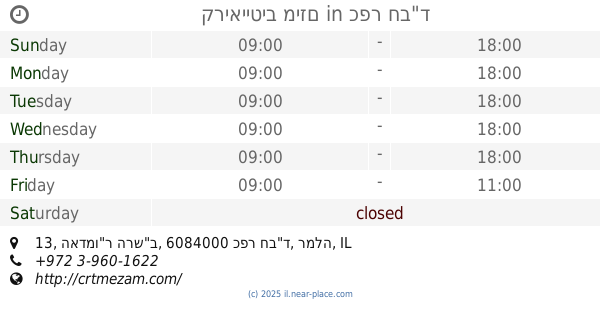
276 m
קריאייטיב מיזם
האדמו"ר הרש"ב 13, כפר חב"ד
Store
read more
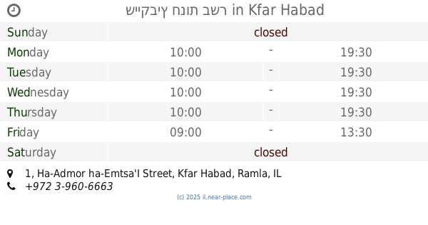
285 m
שייקביץ חנות בשר
Ha-Admor ha-Emtsa'I Street 1, Kfar Habad
Store
read more
285 m
שייקביץ חנות בשר
1, Ha-Admor ha-Emtsa'I Street, Kfar Habad
Store
read more
295 m
שניאורסון דגים ודבש
כפר חב"ד
Store
read more
298 m
קיוסק גיטל
כפר חב"ד
Store
read more
319 m
ריבקין סלולר - מעבדה מקצועית וחנות לסלולר
חנוך לנער 4, Kfar Habad
Store
read more
616 m
whitehillselec
41, כפר חב"ד
Store
read more
616 m
whitehillselec
41, Kfar Habad
Store
read more
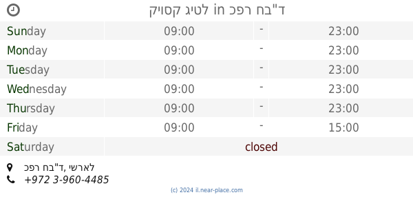
921 m
גוונא תעשיות דפוס מתקדמות
א.ת. מתחם ביה"ס למלאכה, Kfar Habad
Store
read more
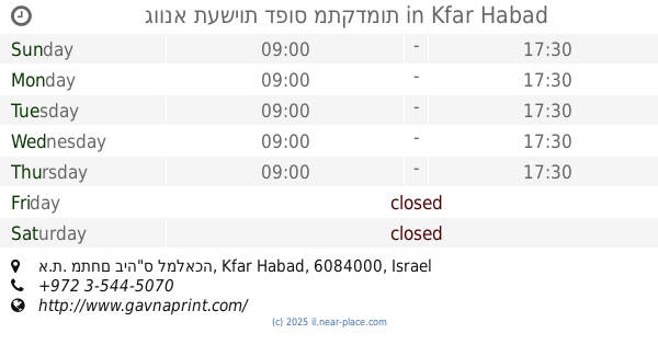
941 m
אהרון כהן שיווק מזון בעמ
203, Kfar Habad
Store
read more
1.025 km
Perlina
Tzemach Tzedek Street 218, כפר חב''ד
Store
read more
1.028 km
לבריאות
צמח צדק 6, כפר חב"ד
Store
read more
1.286 km
Cafe Joe
מתחם חנה וסע, חניון שפירים
Cafe
Convenience store
Food
Point of interest
Store
Establishment
read more
1.585 km
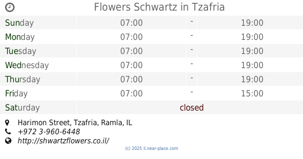
Flowers Schwartz
5, Harimon Street, Tzafria
Store
read more
1.585 km
פרחי שוורץ
5, Harimon Street, Tzafria
Store
read more
1.66 km
טכנו אבי
האתרוג 51, אחיעזר
Store
read more
1.861 km
מובייל גלובל סלולר
טרמינל 3, Ben-Gurion Airport, שדרות התעופה, לוד
Store
read more
1.965 km
פריסטיג' משלוחי פירות
הכרמל 11, בית דגן
Store
read more
2.26 km
Victoia's Secret
Israel
Store
read more
2.269 km
Aroma Espresso Bar ארומה אספרסו בר
ben gurion air port 3, נתב"ג
Cafe
Food
Point of interest
Store
Establishment
read more
📑
all categories
Accounting
Administrative area level 1
Administrative area level 2
Airport
Amusement park
Aquarium
Art gallery
Atm
Bakery
Bank
Bar
Beauty salon
Bicycle store
Book store
Bowling alley
Bus station
Cafe
Campground
Car dealer
Car rental
Car repair
Car wash
Casino
Cemetery
Church
City hall
Clothing store
Colloquial area
Convenience store
Country
Courthouse
Dentist
Department store
Doctor
Electrician
Electronics store
Embassy
Establishment
Finance
Fire station
Florist
Food
Funeral home
Furniture store
Gas station
General contractor
Grocery or supermarket
Gym
Hair care
Hardware store
Health
Hindu Temple
Home goods store
Hospital
Insurance agency
Intersection
Jewelry store
Laundry
Lawyer
Library
Light rail station
Liquor store
Local government office
Locality
Locksmith
Lodging
Meal delivery
Meal takeaway
Mosque
Movie rental
Movie theater
Moving company
Museum
Natural feature
Neighborhood
Night club
Painter
Park
Parking
Pet store
Pharmacy
Physiotherapist
Place of worship
Plumber
Point of interest
Police
Political
Post office
Premise
Real estate agency
Restaurant
Roofing contractor
Route
Rv park, camping
School
Shoe store
Shopping mall
Spa
Stadium
Storage
Store
Subpremise
Subway station
Supermarket
Synagogue
Taxi stand
Train station
Transit station
Travel agency
University
Veterinary care
Zoo
administrative area level 3
administrative area level 4
sublocality level 1
↑