Store nearby מובייל גלובל סלולר
Israel
Store nearby מובייל גלובל סלולר
מובייל גלובל סלולר
שדרות התעופה, לוד, רמלה, IL ישראל
contacts phone
:
+972 3-975-4117
website:
gcellular.net
Latitude:
32.0006603
, Longitude:
34.8702671
larger map & directions
read more
nearest Store
Global Mobile Cellular
טרמינל 3, Ben-Gurion Airport, שדרות התעופה, לוד
Store
read more
417 m
JR/FASHION
Ben Gurion Airport
Store
read more
456 m
Victoia's Secret
Israel
Store
read more
470 m
Aroma Espresso Bar ארומה אספרסו בר
ben gurion air port 3, נתב"ג
Cafe
Food
Point of interest
Store
Establishment
read more
1.169 km
אריק גלרי ארט
הדקל 31, יגל
Store
read more
1.169 km
Eric Art Gallery
HaDekel Street 31, Yagel
Store
read more
1.457 km
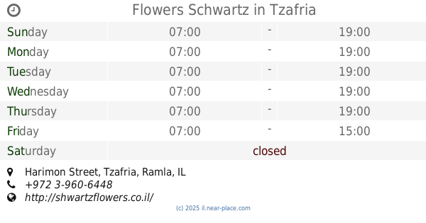
Flowers Schwartz
5, Harimon Street, Tzafria
Store
read more
1.457 km
פרחי שוורץ
5, Harimon Street, Tzafria
Store
read more
1.678 km
טכנו אבי
האתרוג 51, אחיעזר
Store
read more
1.678 km
טכנו אבי
Ha-Etrog Street 51, Ahi'ezer
Store
read more
1.855 km
זלמן סודקביץ ובניו בעמ
ישוב, כפר חב"ד
Store
read more
1.861 km
עוף חבד בעמ
Kfar Habad
Store
read more
1.974 km
מכוורת שניאורסון - כפר חבד
ישוב, Kfar Habad
Store
read more
2.057 km
אהרון כהן שיווק מזון בעמ
203, Kfar Habad
Store
read more
2.057 km
קריאייטיב מיזם
האדמו"ר הרש"ב 13, כפר חב"ד
Store
read more
2.074 km
ריבקין ירקות
246, Kfar Habad
Store
read more
2.088 km
whitehillselec
41, כפר חב"ד
Store
read more
2.088 km
whitehillselec
41, Kfar Habad
Store
read more
2.14 km
שייקביץ חנות בשר
1, Ha-Admor ha-Emtsa'I Street, Kfar Habad
Store
read more
2.14 km
שייקביץ חנות בשר
Ha-Admor ha-Emtsa'I Street 1, Kfar Habad
Store
read more
2.151 km
שניאורסון דגים ודבש
כפר חב"ד
Store
read more
2.152 km
קיוסק גיטל
כפר חב"ד
Store
read more
2.157 km
ריבקין סלולר - מעבדה מקצועית וחנות לסלולר
חנוך לנער 4, Kfar Habad
Store
read more
2.158 km
Perlina
Tzemach Tzedek Street 218, כפר חב''ד
Store
read more
2.194 km
לבריאות
צמח צדק 6, כפר חב"ד
Store
read more
📑
all categories
Accounting
Administrative area level 1
Administrative area level 2
Airport
Amusement park
Aquarium
Art gallery
Atm
Bakery
Bank
Bar
Beauty salon
Bicycle store
Book store
Bowling alley
Bus station
Cafe
Campground
Car dealer
Car rental
Car repair
Car wash
Casino
Cemetery
Church
City hall
Clothing store
Colloquial area
Convenience store
Country
Courthouse
Dentist
Department store
Doctor
Electrician
Electronics store
Embassy
Establishment
Finance
Fire station
Florist
Food
Funeral home
Furniture store
Gas station
General contractor
Grocery or supermarket
Gym
Hair care
Hardware store
Health
Hindu Temple
Home goods store
Hospital
Insurance agency
Intersection
Jewelry store
Laundry
Lawyer
Library
Light rail station
Liquor store
Local government office
Locality
Locksmith
Lodging
Meal delivery
Meal takeaway
Mosque
Movie rental
Movie theater
Moving company
Museum
Natural feature
Neighborhood
Night club
Painter
Park
Parking
Pet store
Pharmacy
Physiotherapist
Place of worship
Plumber
Point of interest
Police
Political
Post office
Premise
Real estate agency
Restaurant
Roofing contractor
Route
Rv park, camping
School
Shoe store
Shopping mall
Spa
Stadium
Storage
Store
Subpremise
Subway station
Supermarket
Synagogue
Taxi stand
Train station
Transit station
Travel agency
University
Veterinary care
Zoo
administrative area level 3
administrative area level 4
sublocality level 1
↑