Shopping mall nearby מרכז מסחרי איזידור
Israel
Shopping mall nearby מרכז מסחרי איזידור
מרכז מסחרי איזידור
אילת, ישראל
contacts phone
:
+972
Latitude:
29.5597949
, Longitude:
34.9454674
larger map & directions
read more
nearest Shopping mall
273 m
Dganiya Shopping Center
Eilat
Shopping mall
read more
273 m
מרכז מסחרי דגניה
אילת
Shopping mall
read more
301 m
Eda ve-Noi Shopping Center
Eilat
Shopping mall
read more
301 m
מרכז מסחרי ידע ונוי
אילת
Shopping mall
read more
324 m
Dekel commercial center
Eilat
Shopping mall
read more
355 m
Ofir Shopping Center
Shkhoret Street, Eilat
Shopping mall
read more
378 m
מרכז מסחרי רסקו
אילת
Shopping mall
read more
493 m
מרכז מסחרי הוכמן
אילת
Shopping mall
read more
493 m
Hokhman Shopping Center
Eilat
Shopping mall
read more
638 m
COOKIES -קוקיס
אנפה 1, אילת
Shopping mall
read more
746 m
מרכז מסחרי אלמוגים
אילת
Shopping mall
read more
746 m
Almogim Shopping Center
Eilat
Shopping mall
read more
844 m
מרכז מסחרי רכטר
אילת
Shopping mall
read more
844 m
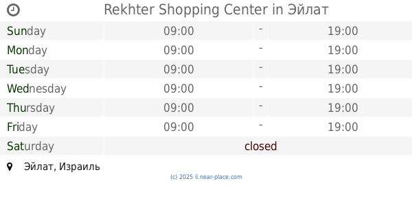
Rekhter Shopping Center
Eilat
Shopping mall
read more
846 m
מרכז מסחרי צופית
אילת
Shopping mall
read more
909 m
מרכז מסחרי יעלים
Eilat
Shopping mall
read more
917 m
מרכז מסחרי שער העיר
אילת
Shopping mall
read more
917 m
Sha'ar Ha-Ir Shopping Center
Eilat
Shopping mall
read more
928 m
Argaman Shopping Center
אילת
Shopping mall
read more
936 m
חנויות עציון
Sderot HaTmarim Boulevard 1, אילת
Shopping mall
read more
989 m
מרכז שלום
Sderot HaTmarim 2, Eilat
Shopping mall
read more
989 m
מרכז שלום
שדרות התמרים 2, אילת
Shopping mall
read more
1.012 km
קניון השלום
שדרות התמרים 2, אילת
Shopping mall
read more
1.135 km
הפיראט האדום אילת
שדרות חטיבת גולני, אילת
Shopping mall
read more
1.268 km
ואדי שחמון
אילת
Shopping mall
read more
📑
all categories
Accounting
Administrative area level 1
Administrative area level 2
Airport
Amusement park
Aquarium
Art gallery
Atm
Bakery
Bank
Bar
Beauty salon
Bicycle store
Book store
Bowling alley
Bus station
Cafe
Campground
Car dealer
Car rental
Car repair
Car wash
Casino
Cemetery
Church
City hall
Clothing store
Colloquial area
Convenience store
Country
Courthouse
Dentist
Department store
Doctor
Electrician
Electronics store
Embassy
Establishment
Finance
Fire station
Florist
Food
Funeral home
Furniture store
Gas station
General contractor
Grocery or supermarket
Gym
Hair care
Hardware store
Health
Hindu Temple
Home goods store
Hospital
Insurance agency
Intersection
Jewelry store
Laundry
Lawyer
Library
Light rail station
Liquor store
Local government office
Locality
Locksmith
Lodging
Meal delivery
Meal takeaway
Mosque
Movie rental
Movie theater
Moving company
Museum
Natural feature
Neighborhood
Night club
Painter
Park
Parking
Pet store
Pharmacy
Physiotherapist
Place of worship
Plumber
Point of interest
Police
Political
Post office
Premise
Real estate agency
Restaurant
Roofing contractor
Route
Rv park, camping
School
Shoe store
Shopping mall
Spa
Stadium
Storage
Store
Subpremise
Subway station
Supermarket
Synagogue
Taxi stand
Train station
Transit station
Travel agency
University
Veterinary care
Zoo
administrative area level 3
administrative area level 4
sublocality level 1
↑