School nearby כלנית
Israel
School nearby כלנית
כלנית
11, Ha-Ma'alot Street, Ra'anana, Petach Tikva, IL Israel
contacts phone
:
+972
Latitude:
32.1788929
, Longitude:
34.8746589
larger map & directions
read more
nearest School
105 m
Tomatis Israel - central area
Jabotinski Street 12, Ra'anana
School
read more
173 m
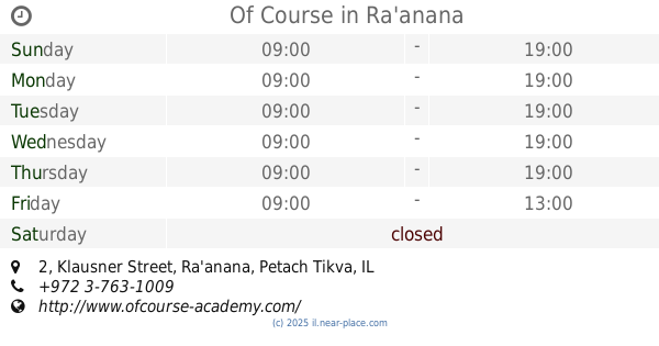
Of Course
Klausner Street 2, Ra'anana
School
read more
298 m
רזימטיקה
אחוזה 100, רעננה
School
read more
355 m
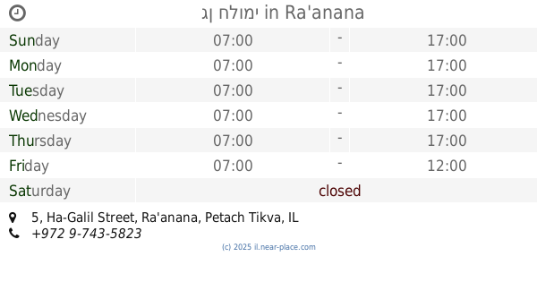
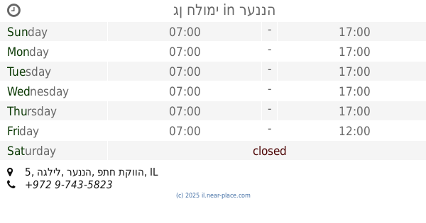
גן חלומי
Ha-Galil Street 5, Ra'anana
School
read more
355 m
גן חלומי
הגליל 5, רעננה
School
read more
449 m
גן ילדים "אורגניל'ה"
אופסטרלנד 5, רעננה
School
read more
449 m
גן ילדים "אורגניל'ה"
Opsterland Street 5, Ra'anana
School
read more
452 m
Ankori high school
Ahuza Street 148, Ra'anana
School
read more
553 m
המכון לאמיתות התורה
אחוזה 68, רעננה
School
read more
553 m
המכון לאמיתות התורה
Ahuza Street 68, Ra'anana
School
read more
594 m
גן האפרוחים של ליזי וגילי
פרדס משותף 5, רעננה
School
read more
594 m
גן האפרוחים של ליזי וגילי
Pardes Meshutaf Street 5, Ra'anana
School
read more
710 m
גן ברוש
שברץ 12, רעננה
School
read more
726 m
אמית כפר בתיה
רעננה
School
read more
768 m
בי"ס ממ"ד ביל"ו
ביל"ו 15, רעננה
School
read more
768 m
Bilu School
Bilu Street 15, Ra'anana
School
read more
817 m
Tut Kindegarden
Herzl Street 86, Ra'anana
School
read more
878 m
Dekel Elementary School
שברץ 24, רעננה
School
read more
878 m
Dekel Elementary School
Schwarz Street 24, Ra'anana
School
read more
896 m
בי"ס חינוך עצמאי
רמח"ל 7, רעננה
School
read more
944 m
Raanana Kollel
אחוזה 182-198, רעננה
School
read more
948 m
גן תפוח
Abarbanel Street 3, Ra'anana
School
read more
949 m
Yonatan Junior High
Rashi Street 19, Ra'anana
School
read more
1.089 km
Hadar School
HaGdud Haivri Street 9, Ra'anana
School
read more
1.132 km
גן רותי ואורלי
Arye Street 7, Ra'anana
School
read more
📑
all categories
Accounting
Administrative area level 1
Administrative area level 2
Airport
Amusement park
Aquarium
Art gallery
Atm
Bakery
Bank
Bar
Beauty salon
Bicycle store
Book store
Bowling alley
Bus station
Cafe
Campground
Car dealer
Car rental
Car repair
Car wash
Casino
Cemetery
Church
City hall
Clothing store
Colloquial area
Convenience store
Country
Courthouse
Dentist
Department store
Doctor
Electrician
Electronics store
Embassy
Establishment
Finance
Fire station
Florist
Food
Funeral home
Furniture store
Gas station
General contractor
Grocery or supermarket
Gym
Hair care
Hardware store
Health
Hindu Temple
Home goods store
Hospital
Insurance agency
Intersection
Jewelry store
Laundry
Lawyer
Library
Light rail station
Liquor store
Local government office
Locality
Locksmith
Lodging
Meal delivery
Meal takeaway
Mosque
Movie rental
Movie theater
Moving company
Museum
Natural feature
Neighborhood
Night club
Painter
Park
Parking
Pet store
Pharmacy
Physiotherapist
Place of worship
Plumber
Point of interest
Police
Political
Post office
Premise
Real estate agency
Restaurant
Roofing contractor
Route
Rv park, camping
School
Shoe store
Shopping mall
Spa
Stadium
Storage
Store
Subpremise
Subway station
Supermarket
Synagogue
Taxi stand
Train station
Transit station
Travel agency
University
Veterinary care
Zoo
administrative area level 3
administrative area level 4
sublocality level 1
↑