School nearby Hadar School
Israel
School nearby Hadar School
Hadar School
9, HaGdud Haivri Street, Ra'anana, Petach Tikva, IL Израиль
contacts phone
:
+972 9-771-2833
website:
t19.tik-tak.co.il
Latitude:
32.1848886
, Longitude:
34.8655098
larger map & directions
read more
nearest School
בי"ס הדר
הגדוד העברי 9, רעננה
School
read more
242 m
Raanana Kollel
אחוזה 182-198, רעננה
School
read more
395 m
גן רותי ואורלי
Arye Street 7, Ra'anana
School
read more
501 m
בי"ס חינוך עצמאי
רמח"ל 7, רעננה
School
read more
501 m
Independent school education official religious institution
Ramkhal Street 7, Ra'anana
School
read more
547 m
אמית כפר בתיה
רעננה
School
read more
636 m
Bilu School
Bilu Street 15, Ra'anana
School
read more
636 m
בי"ס ממ"ד ביל"ו
ביל"ו 15, רעננה
School
read more
638 m
Ankori high school
Ahuza Street 148, Ra'anana
School
read more
659 m
גן ילדים "אורגניל'ה"
Opsterland Street 5, Ra'anana
School
read more
659 m
גן ילדים "אורגניל'ה"
אופסטרלנד 5, רעננה
School
read more
673 m
גן האפרוחים של אפרת
Shmu'el HaNagid Street 5, Ra'anana
School
read more
786 m
בית הספר פעמונים
הפעמונים 18, רעננה
School
read more
786 m
Pa'amonim School
Ha-Pa'amonim Street 18, Ra'anana
School
read more
801 m
בית ספר פעמונים רעננה
הפעמונים 11, רעננה
School
read more
940 m
חטיבת ביניים מיתרים רעננה
שמואל הנגיד 37, רעננה
School
read more
950 m
Meitarim Raanana Pluralistic Jewish School
Shmu'el HaNagid Street 37, Ra'anana
School
read more
979 m
תיכון אביב
הפרחים 1, רעננה
School
read more
1.007 km
Tomatis Israel - central area
Jabotinski Street 12, Ra'anana
School
read more
1.007 km
Tomatis Israel - central area
ז'בוטינסקי 12, רעננה
School
read more
1.051 km
חטב ותיכון אמית רננים
רעננה
School
read more
1.1 km
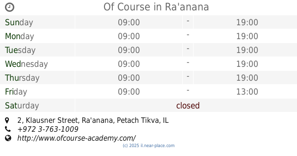
Of Course
Klausner Street 2, Ra'anana
School
read more
1.155 km
Meged School
Ahuza Street 105, Ra'anana
School
read more
1.175 km
Matan Hasharon
Ha-Palmakh Street 4, Ra'anana
School
read more
1.33 km
Ziv School
Klausner Street 27, Ra'anana
School
read more
📑
all categories
Accounting
Administrative area level 1
Administrative area level 2
Airport
Amusement park
Aquarium
Art gallery
Atm
Bakery
Bank
Bar
Beauty salon
Bicycle store
Book store
Bowling alley
Bus station
Cafe
Campground
Car dealer
Car rental
Car repair
Car wash
Casino
Cemetery
Church
City hall
Clothing store
Colloquial area
Convenience store
Country
Courthouse
Dentist
Department store
Doctor
Electrician
Electronics store
Embassy
Establishment
Finance
Fire station
Florist
Food
Funeral home
Furniture store
Gas station
General contractor
Grocery or supermarket
Gym
Hair care
Hardware store
Health
Hindu Temple
Home goods store
Hospital
Insurance agency
Intersection
Jewelry store
Laundry
Lawyer
Library
Light rail station
Liquor store
Local government office
Locality
Locksmith
Lodging
Meal delivery
Meal takeaway
Mosque
Movie rental
Movie theater
Moving company
Museum
Natural feature
Neighborhood
Night club
Painter
Park
Parking
Pet store
Pharmacy
Physiotherapist
Place of worship
Plumber
Point of interest
Police
Political
Post office
Premise
Real estate agency
Restaurant
Roofing contractor
Route
Rv park, camping
School
Shoe store
Shopping mall
Spa
Stadium
Storage
Store
Subpremise
Subway station
Supermarket
Synagogue
Taxi stand
Train station
Transit station
Travel agency
University
Veterinary care
Zoo
administrative area level 3
administrative area level 4
sublocality level 1
↑