Restaurant nearby Vegantino
Coronavirus disease (COVID-19) Situation
confirmed cases
4841772
deaths
12707
Israel
Restaurant nearby Vegantino
Vegantino
Karmiel, Israel
contacts phone
:
+972 52-500-2226
website:
www.vegantino.co.il
Latitude:
32.8200867
, Longitude:
35.2896704
larger map & directions
read more
nearest Restaurant
1.637 km
Goats With The Wind
Yodfat
Restaurant
read more
2.401 km
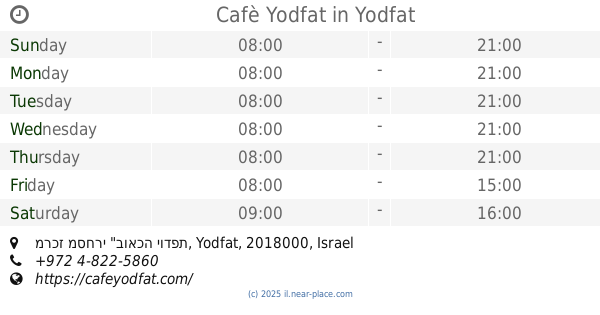
Cafè Yodfat
מרכז מסחרי "בואכה יודפת, Yodfat
Restaurant
Food
Point of interest
Establishment
read more
2.414 km
קפה יודפת
יודפת
Restaurant
read more
2.414 km
Yodfat Cafe
Yodfat
Restaurant
read more
2.414 km
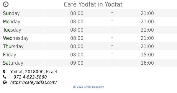
Cafè Yodfat
Yodfat
Restaurant
Food
Point of interest
Establishment
read more
2.613 km
مطعم إبقوا طلوا
Kafr Manda
Restaurant
read more
2.613 km
مطعم إبقوا طلوا
כפר מנדא
Restaurant
read more
2.786 km
Burger Town
ספוריה, כפר מנדא
Restaurant
read more
2.786 km
Burger Town
Safurie Street, Kafr Manda
Restaurant
read more
2.792 km
مطعم المندالاوي
כפר מנדא
Restaurant
read more
2.792 km
مطعم المندالاوي
Kafr Manda
Restaurant
read more
2.805 km
بيتسا العين
כפר מנדא
Restaurant
read more
2.805 km
بيتسا العين
Kafr Manda
Restaurant
read more
2.831 km
Nur al-Din
El Bustan Street, Kafr Manda
Restaurant
read more
2.974 km
V.IP cafe
Kafr Manda
Restaurant
read more
2.974 km
V.IP cafe
כפר מנדא
Restaurant
read more
3.026 km
מסעדה אחים מנדלאוי
ישוב, Kafr Manda
Restaurant
read more
3.088 km
מסעדת אלמלכי
38 Street, Kafr Manda
Restaurant
read more
3.088 km
מסעדת אלמלכי
38, כפר מנדא
Restaurant
read more
3.125 km
בגיטה
El Bustan St., כפר מנדא
Restaurant
read more
3.125 km
בגיטה باجيتا Bagetta
אל בוסתאן, כפר מנדא
Restaurant
read more
3.125 km
בגיטה باجيتا Bagetta
El Bustan Street, Kafr Manda
Restaurant
read more
3.139 km
Bagetta Restaurant
Al-Bustan, Kafr Manda
Restaurant
read more
3.206 km
ממתקי ביסאן
Kafr Manda
Restaurant
read more
5.262 km
Alrobian
דור אלון, כביש 784
Restaurant
read more
📑
all categories
Accounting
Administrative area level 1
Administrative area level 2
Airport
Amusement park
Aquarium
Art gallery
Atm
Bakery
Bank
Bar
Beauty salon
Bicycle store
Book store
Bowling alley
Bus station
Cafe
Campground
Car dealer
Car rental
Car repair
Car wash
Casino
Cemetery
Church
City hall
Clothing store
Colloquial area
Convenience store
Country
Courthouse
Dentist
Department store
Doctor
Electrician
Electronics store
Embassy
Establishment
Finance
Fire station
Florist
Food
Funeral home
Furniture store
Gas station
General contractor
Grocery or supermarket
Gym
Hair care
Hardware store
Health
Hindu Temple
Home goods store
Hospital
Insurance agency
Intersection
Jewelry store
Laundry
Lawyer
Library
Light rail station
Liquor store
Local government office
Locality
Locksmith
Lodging
Meal delivery
Meal takeaway
Mosque
Movie rental
Movie theater
Moving company
Museum
Natural feature
Neighborhood
Night club
Painter
Park
Parking
Pet store
Pharmacy
Physiotherapist
Place of worship
Plumber
Point of interest
Police
Political
Post office
Premise
Real estate agency
Restaurant
Roofing contractor
Route
Rv park, camping
School
Shoe store
Shopping mall
Spa
Stadium
Storage
Store
Subpremise
Subway station
Supermarket
Synagogue
Taxi stand
Train station
Transit station
Travel agency
University
Veterinary care
Zoo
administrative area level 3
administrative area level 4
sublocality level 1
↑