Restaurant nearby dizi cream
Israel
Restaurant nearby dizi cream
dizi cream
145, Dizengoff Street, Tel Aviv-Yafo, IL Израиль
contacts phone
:
+972
Latitude:
32.0827295
, Longitude:
34.7736874
larger map & directions
read more
nearest Restaurant
151 m
The Little Burger Shop
Dizengoff Street 125, Tel Aviv-Yafo
Restaurant
read more
229 m
דיאלנא
בן יהודה 89, תל אביב יפו
Restaurant
read more
235 m
דוניא
Ben Yehuda Street 89, Tel Aviv-Yafo
Restaurant
read more
347 m
Сабих
Frishman Street 42, Tel Aviv-Yafo
Restaurant
read more
368 m
Osteria da Fiorella Restaurant
Ben Yehuda Street 148, Tel Aviv-Yafo
Restaurant
read more
381 m
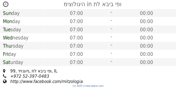
מיצולוגיה
דיזנגוף 99, תל אביב יפו
Restaurant
read more
504 m
מאמא ציפורה
Ben Yehuda Street 63, Tel Aviv-Yafo
Restaurant
read more
532 m
Panorama
תל אביב יפו
Restaurant
read more
594 m
Shangrila
הירקון 105, תל אביב יפו
Restaurant
read more
594 m
Shangrila
HaYarkon Street 105, Tel Aviv-Yafo
Restaurant
read more
670 m
הירקון 99
הירקון 99, תל אביב יפו
Restaurant
read more
673 m
יאנס - חומוס פלפל
Frishman Street 88, Tel Aviv-Yafo
Restaurant
read more
716 m
Ami HaShamen
Ben Yehuda Street 48, Tel Aviv-Yafo
Restaurant
read more
730 m
עמי השמן
Ben Yehuda Street 48, Tel Aviv-Yafo
Restaurant
read more
730 m
Хумусия
Shlomo Ibn Gabirol Street 90, Tel Aviv-Yafo
Restaurant
read more
760 m
Chloelys
מלון הילטון, Ha-Yarkon Street 205, Tel Aviv-Yafo
Restaurant
read more
762 m
פלאפל רומיה
שלמה אבן גבירול 104, תל אביב יפו
Restaurant
read more
769 m
Тай Хаус
Bograshov Street 8, Tel Aviv-Yafo
Restaurant
read more
797 m
Mashawsha
Pinsker Street 40, Tel Aviv-Yafo
Restaurant
read more
799 m
Mundo
HaYarkon Street 88, Tel Aviv-Yafo
Restaurant
read more
878 m
McDonald's
HaYarkon Street 81, Tel Aviv-Yafo
Restaurant
read more
922 m
Armando-kosher fish&meat restaurant
Retsif Herbert Samuel Street 88, Tel Aviv-Yafo
Restaurant
read more
937 m
Keter Hamizrah
Ibn Gabirol Street 115, Tel Aviv-Yafo
Restaurant
read more
975 m
רוסטיקו
בזל 42, תל אביב יפו
Restaurant
read more
1.255 km
בורגר פקטורי אקספרס
שלמה אבן גבירול 22, תל אביב יפו
Restaurant
read more
📑
all categories
Accounting
Administrative area level 1
Administrative area level 2
Airport
Amusement park
Aquarium
Art gallery
Atm
Bakery
Bank
Bar
Beauty salon
Bicycle store
Book store
Bowling alley
Bus station
Cafe
Campground
Car dealer
Car rental
Car repair
Car wash
Casino
Cemetery
Church
City hall
Clothing store
Colloquial area
Convenience store
Country
Courthouse
Dentist
Department store
Doctor
Electrician
Electronics store
Embassy
Establishment
Finance
Fire station
Florist
Food
Funeral home
Furniture store
Gas station
General contractor
Grocery or supermarket
Gym
Hair care
Hardware store
Health
Hindu Temple
Home goods store
Hospital
Insurance agency
Intersection
Jewelry store
Laundry
Lawyer
Library
Light rail station
Liquor store
Local government office
Locality
Locksmith
Lodging
Meal delivery
Meal takeaway
Mosque
Movie rental
Movie theater
Moving company
Museum
Natural feature
Neighborhood
Night club
Painter
Park
Parking
Pet store
Pharmacy
Physiotherapist
Place of worship
Plumber
Point of interest
Police
Political
Post office
Premise
Real estate agency
Restaurant
Roofing contractor
Route
Rv park, camping
School
Shoe store
Shopping mall
Spa
Stadium
Storage
Store
Subpremise
Subway station
Supermarket
Synagogue
Taxi stand
Train station
Transit station
Travel agency
University
Veterinary care
Zoo
administrative area level 3
administrative area level 4
sublocality level 1
↑