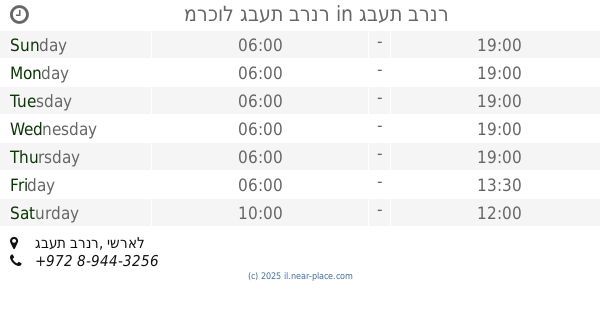
Convenience store nearby Jacob Farm
Israel
Convenience store nearby Jacob Farm
Jacob Farm
149-150, HaGefen Street, Kidron, Rehovot, IL Израиль
contacts phone
:
+972 52-278-1181
Latitude:
31.8091764
, Longitude:
34.8022093
larger map & directions
read more
nearest Convenience store
6.335 km
Supermarket Givat Brenner
Givat Brenner
Convenience store
read more
6.335 km
מרכול גבעת ברנר
גבעת ברנר
Convenience store
read more
6.515 km
צרכנית בית גמליאל
בית גמליאל
Convenience store
read more
8.43 km
Kiosk - קיוסק פיצוציה
HaNahshol Street 22, Yavne
Convenience store
read more
8.576 km
המכולת של עופר
Efrayim Zakhs Street 34, Rehovot
Convenience store
read more
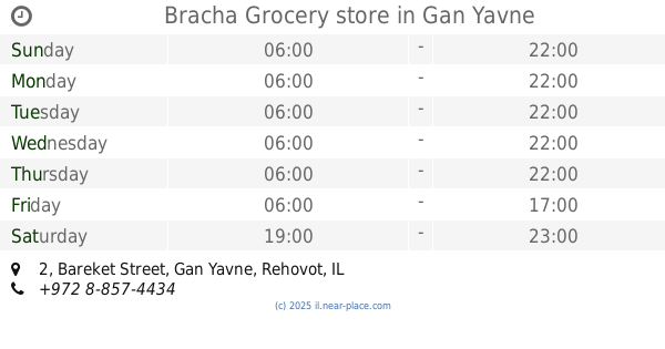
8.9 km
Bracha Grocery store
Bareket Street 2, Gan Yavne
Convenience store
read more
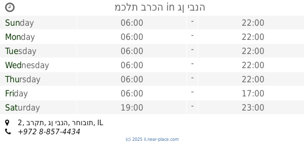
8.9 km
מכלת ברכה
ברקת 2, גן יבנה
Convenience store
read more
8.922 km
סנקס
HaDogit Street 16, Yavne
Convenience store
read more
9.094 km
כלבו
כפר מנחם
Convenience store
read more
9.338 km
אצל כהן - חנות הנוחות שלך
Herzl Street 150, Rehovot
Atm
Convenience store
Finance
Cafe
Liquor store
Food
Point of interest
Store
Establishment
read more
9.472 km
סופר חסד בעמ
Y.L. Perets Street 8, Rehovot
Grocery or supermarket
Convenience store
Supermarket
Food
Store
Point of interest
Establishment
read more
10.399 km
מינימרקט גורדון
A.D. Gordon Street 30, Rehovot
Convenience store
read more
10.399 km
מינימרקט גורדון
א.ד. גורדון 30, רחובות
Convenience store
read more
10.695 km
מכולת גבי - תמי
נחלת הר חב"ד 4, קרית מלאכי
Convenience store
read more
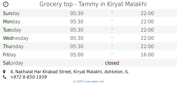
10.695 km
Grocery top - Tammy
Nakhalat Har Khabad Street 4, Kiryat Malakhi
Convenience store
read more
12.716 km
מכולת קרן
חצור 4, בת ים
Convenience store
read more
13.547 km
מינימרקט האומנים
שושנה דמארי, רמלה
Convenience store
read more
13.547 km
מינימרקט האומנים
Shoshana Damari Street, Ramla
Convenience store
read more
14.66 km
Grocery Store
Nahshon
Convenience store
read more
15.38 km
מכולת האחים
Yosef Shprintsak Street, Ramla
Convenience store
read more
16.568 km
Grocery Store
Palmachim
Convenience store
read more
17.378 km
פיצוציית ראש בראש
קרית ספר 1, ראשון לציון
Convenience store
read more
22.437 km
Yellow חנות הנוחות של פז
Israel
Convenience store
read more
22.909 km
המותג
החי"ל 22, חולון
Convenience store
read more
23.976 km
מינימרקט האחים
Yoseftal Street 21, Bat Yam
Convenience store
read more
📑
all categories
Accounting
Administrative area level 1
Administrative area level 2
Airport
Amusement park
Aquarium
Art gallery
Atm
Bakery
Bank
Bar
Beauty salon
Bicycle store
Book store
Bowling alley
Bus station
Cafe
Campground
Car dealer
Car rental
Car repair
Car wash
Casino
Cemetery
Church
City hall
Clothing store
Colloquial area
Convenience store
Country
Courthouse
Dentist
Department store
Doctor
Electrician
Electronics store
Embassy
Establishment
Finance
Fire station
Florist
Food
Funeral home
Furniture store
Gas station
General contractor
Grocery or supermarket
Gym
Hair care
Hardware store
Health
Hindu Temple
Home goods store
Hospital
Insurance agency
Intersection
Jewelry store
Laundry
Lawyer
Library
Light rail station
Liquor store
Local government office
Locality
Locksmith
Lodging
Meal delivery
Meal takeaway
Mosque
Movie rental
Movie theater
Moving company
Museum
Natural feature
Neighborhood
Night club
Painter
Park
Parking
Pet store
Pharmacy
Physiotherapist
Place of worship
Plumber
Point of interest
Police
Political
Post office
Premise
Real estate agency
Restaurant
Roofing contractor
Route
Rv park, camping
School
Shoe store
Shopping mall
Spa
Stadium
Storage
Store
Subpremise
Subway station
Supermarket
Synagogue
Taxi stand
Train station
Transit station
Travel agency
University
Veterinary care
Zoo
administrative area level 3
administrative area level 4
sublocality level 1
↑