Convenience store nearby Grocery Store
Israel
Convenience store nearby Grocery Store
Grocery Store
Palmachim, Israel
contacts phone
:
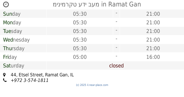
+972
Latitude:
31.9335518
, Longitude:
34.7055585
larger map & directions
read more
nearest Convenience store
4.071 km
מכולת קרן
חצור 4, בת ים
Convenience store
read more
7.997 km
סנקס
HaDogit Street 16, Yavne
Convenience store
read more
8.469 km
Kiosk - קיוסק פיצוציה
HaNahshol Street 22, Yavne
Convenience store
read more
9.538 km
פיצוציית ראש בראש
קרית ספר 1, ראשון לציון
Convenience store
read more
9.911 km
Элиша
HaHaroshet Street 1, Bat Yam
Convenience store
read more
10.071 km
צרכנית בית גמליאל
בית גמליאל
Convenience store
read more
10.119 km
מינימרקט האחים
Yoseftal Street 21, Bat Yam
Convenience store
read more
10.227 km
Open Market
Derech Ben Gurion 73, Bat Yam
Convenience store
read more
10.458 km
כלבו מזל
פנחס לבון 17, חולון
Convenience store
read more
10.642 km
המותג
HaHayil Street 22, Holon
Convenience store
read more
10.642 km
המותג
החי"ל 22, חולון
Convenience store
read more
10.765 km
מינימרקט גורדון
A.D. Gordon Street 30, Rehovot
Convenience store
read more
11.716 km
Supermarket Givat Brenner
Givat Brenner
Convenience store
read more
12.495 km
מינימרקט נור יפו
דב ממזריץ' 22, תל אביב יפו
Convenience store
read more
13.785 km
מתחם פז סנטר בן צבי
Derekh Ben-Zvi 46, Tel Aviv-Yafo
Convenience store
read more
15.007 km
City Market
HaRav Yizkhak Yedidya Frenkel 28, Tel Aviv-Yafo
Convenience store
read more
15.351 km
מרי-מרקט
HaAliya Street 22, Tel Aviv-Yafo
Convenience store
read more
15.369 km
קיוסק
לוינסקי 41, תל אביב יפו
Convenience store
read more
15.394 km
מינימרקט לוינסקי
לוינסקי 77, תל אביב יפו
Convenience store
read more
15.642 km
מכולת פנחס
בושם 12, תל אביב יפו
Convenience store
read more
15.717 km
כתם הפרי
נחלת בנימין 65, תל אביב יפו
Convenience store
read more
15.797 km
Grocery Altrntiib
Mahal Street 20, Tel Aviv-Yafo
Convenience store
read more
15.893 km
צרכניה 205
דרך חיים ברלב 205, תל אביב יפו
Convenience store
read more
17.453 km
שוקי מרקט רמת חן
HaMe'a Ve'ehad Street 45, Ramat Gan
Convenience store
read more
19.422 km
מינימרקט עדי בעמ
Etsel Street 44, Ramat Gan
Convenience store
Supermarket
Grocery or supermarket
Food
Point of interest
Store
Establishment
read more
📑
all categories
Accounting
Administrative area level 1
Administrative area level 2
Airport
Amusement park
Aquarium
Art gallery
Atm
Bakery
Bank
Bar
Beauty salon
Bicycle store
Book store
Bowling alley
Bus station
Cafe
Campground
Car dealer
Car rental
Car repair
Car wash
Casino
Cemetery
Church
City hall
Clothing store
Colloquial area
Convenience store
Country
Courthouse
Dentist
Department store
Doctor
Electrician
Electronics store
Embassy
Establishment
Finance
Fire station
Florist
Food
Funeral home
Furniture store
Gas station
General contractor
Grocery or supermarket
Gym
Hair care
Hardware store
Health
Hindu Temple
Home goods store
Hospital
Insurance agency
Intersection
Jewelry store
Laundry
Lawyer
Library
Light rail station
Liquor store
Local government office
Locality
Locksmith
Lodging
Meal delivery
Meal takeaway
Mosque
Movie rental
Movie theater
Moving company
Museum
Natural feature
Neighborhood
Night club
Painter
Park
Parking
Pet store
Pharmacy
Physiotherapist
Place of worship
Plumber
Point of interest
Police
Political
Post office
Premise
Real estate agency
Restaurant
Roofing contractor
Route
Rv park, camping
School
Shoe store
Shopping mall
Spa
Stadium
Storage
Store
Subpremise
Subway station
Supermarket
Synagogue
Taxi stand
Train station
Transit station
Travel agency
University
Veterinary care
Zoo
administrative area level 3
administrative area level 4
sublocality level 1
↑