Cafe nearby cofizz
Coronavirus disease (COVID-19) Situation
confirmed cases
4841772
deaths
12707
Israel
Cafe nearby cofizz
cofizz
77, Bialik Street, Ramat Gan, IL Israel
contacts phone
:
+972 1-700-502-350
website:
www.cofizz.co.il
Latitude:
32.0855358
, Longitude:
34.8111283
larger map & directions
read more
nearest Cafe
379 m
קופיקס
ביאליק 46, רמת גן
Cafe
read more
379 m
Кофикс
Bialik Street 46, Ramat Gan
Cafe
read more
470 m
Tartuga Bakery
HaHashmona'im Street 23, Ramat Gan
Cafe
read more
725 m
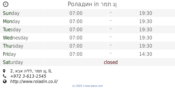
Роладин
אבא הילל 2, רמת גן
Cafe
read more
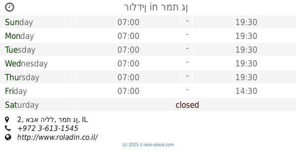
725 m
רולדין
אבא הילל 2, רמת גן
Cafe
read more
736 m
Taxi Coffee
Bialik Street 14, Ramat Gan
Cafe
read more
758 m
קפה 5
Bialik Street 7, Ramat Gan
Cafe
read more
768 m
Familia De Cafe
Tuval Street 17, Ramat Gan
Cafe
read more
768 m
Familia De Cafe
תובל 17, רמת גן
Cafe
read more
769 m
Аркафе
בית הראל, מתחם הבורסה, דרך אבא הלל 3, רמת-גן
Cafe
read more
823 m
קונדיטורית שני
רח' זאב ז'בוטינסקי 5, רמת גן
Cafe
read more
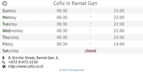
827 m
Cofix
Krinitsi Street 8, Ramat Gan
Cafe
read more
833 m
Kabis
Ha-Yetsira Street 19, Ramat Gan
Cafe
read more
844 m
Naknikiyalik Hot Dogs
1st bialik st, רמת גן
Cafe
read more
845 m
Big Ben time cafe
Ha-Yetsira Street 22, Ramat Gan
Cafe
read more
864 m
קפה מילאנו-בורסת היהלומים
תובל 21, רמת גן
Cafe
read more
912 m
Tom's cafe
Sirkin Street 16, Ramat Gan
Cafe
Food
Point of interest
Store
Establishment
read more
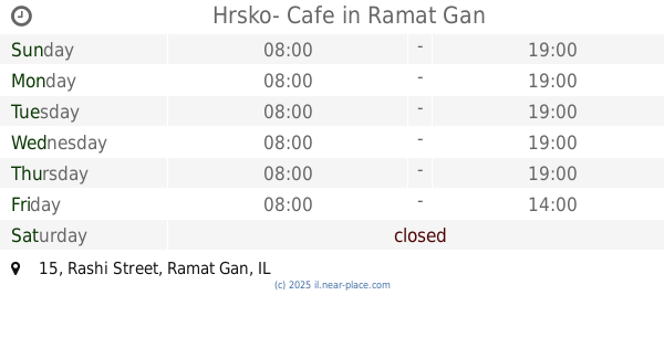
940 m
Hrsko- Cafe
Rashi Street 15, Ramat Gan
Cafe
read more
963 m
Coffee Garden
Ha-Marganit Street 10, Ramat Gan
Cafe
read more
980 m
קפה אלברטיקו
כצנלסון 113, גבעתיים
Cafe
read more
984 m
קפה גידי
David Ben Gurion Road 108, Ramat Gan
Cafe
Restaurant
Food
Point of interest
Store
Establishment
read more
1.028 km
קופי אקספרס
Ze'ev Jabotinsky Street 1, Ramat Gan
Cafe
read more
1.028 km
קופי אקספרס
רח' זאב ז'בוטינסקי 1, רמת גן
Cafe
read more
1.057 km
Ilan's Coffee
ז'בוטינסקי 2, רמת גן
Cafe
read more
1.153 km
קפיטריה תלמה ילין
בורוכוב 5, גבעתיים
Cafe
read more
📑
all categories
Accounting
Administrative area level 1
Administrative area level 2
Airport
Amusement park
Aquarium
Art gallery
Atm
Bakery
Bank
Bar
Beauty salon
Bicycle store
Book store
Bowling alley
Bus station
Cafe
Campground
Car dealer
Car rental
Car repair
Car wash
Casino
Cemetery
Church
City hall
Clothing store
Colloquial area
Convenience store
Country
Courthouse
Dentist
Department store
Doctor
Electrician
Electronics store
Embassy
Establishment
Finance
Fire station
Florist
Food
Funeral home
Furniture store
Gas station
General contractor
Grocery or supermarket
Gym
Hair care
Hardware store
Health
Hindu Temple
Home goods store
Hospital
Insurance agency
Intersection
Jewelry store
Laundry
Lawyer
Library
Light rail station
Liquor store
Local government office
Locality
Locksmith
Lodging
Meal delivery
Meal takeaway
Mosque
Movie rental
Movie theater
Moving company
Museum
Natural feature
Neighborhood
Night club
Painter
Park
Parking
Pet store
Pharmacy
Physiotherapist
Place of worship
Plumber
Point of interest
Police
Political
Post office
Premise
Real estate agency
Restaurant
Roofing contractor
Route
Rv park, camping
School
Shoe store
Shopping mall
Spa
Stadium
Storage
Store
Subpremise
Subway station
Supermarket
Synagogue
Taxi stand
Train station
Transit station
Travel agency
University
Veterinary care
Zoo
administrative area level 3
administrative area level 4
sublocality level 1
↑