Cafe nearby Taxi Coffee
Israel
Cafe nearby Taxi Coffee
Taxi Coffee
14, Bialik Street, Ramat Gan, IL Израиль
contacts phone
:
+972
Latitude:
32.0796738
, Longitude:
34.8147603
larger map & directions
read more
nearest Cafe
22 m
קפה 5
Bialik Street 7, Ramat Gan
Cafe
read more
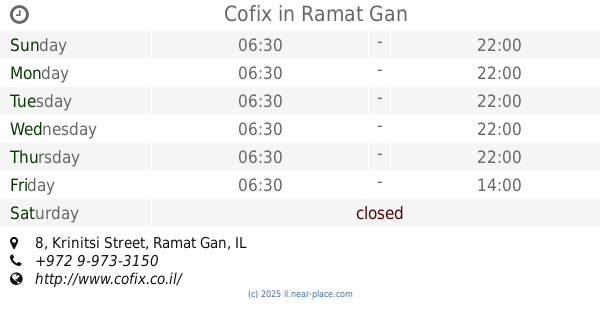
102 m
Cofix
Krinitsi Street 8, Ramat Gan
Cafe
read more
115 m
Naknikiyalik Hot Dogs
1st bialik st, רמת גן
Cafe
read more
185 m
Tom's cafe
Sirkin Street 16, Ramat Gan
Cafe
Food
Point of interest
Store
Establishment
read more
311 m
קפה אלברטיקו
כצנלסון 113, גבעתיים
Cafe
read more
400 m
Viola Café
Sheinkin Street 49, Giv'atayim
Restaurant
Cafe
Food
Point of interest
Establishment
read more
444 m
Кофикс
Bialik Street 46, Ramat Gan
Cafe
read more
444 m
קופיקס
ביאליק 46, רמת גן
Cafe
read more
455 m
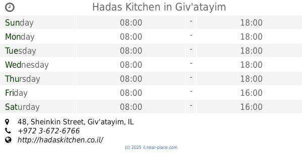
Hadas Kitchen
Sheinkin Street 48, Giv'atayim
Cafe
read more
455 m
הדס Kitchen
שיינקין 48, גבעתיים
Cafe
read more
485 m
רולדין
בורוכוב 54, גבעתיים
Cafe
read more
485 m
רולדין
Borochov Street 54, Giv'atayim
Cafe
read more
523 m
Tartuga Bakery
HaHashmona'im Street 23, Ramat Gan
Cafe
read more
529 m
קישריה
כצנלסון 147, גבעתיים
Cafe
read more
651 m
פינה חמה
דרך בן גוריון 181, רמת גן
Cafe
read more
651 m
פינה חמה
Derech Ben Gurion 181, Ramat Gan
Cafe
read more
748 m
Cafe Zelik
Sheinkin Street 3, Giv'atayim
Cafe
Food
Point of interest
Store
Establishment
read more
795 m
קפה גידי
David Ben Gurion Road 108, Ramat Gan
Cafe
Restaurant
Food
Point of interest
Store
Establishment
read more
808 m
Cofix Givatayim
Katzenelson Street 61, Giv'atayim
Cafe
read more
836 m
קופי טופי
מקדונלד 2, רמת גן
Cafe
read more
892 m
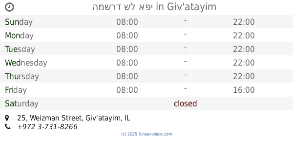
המשרד של אפי
Weizman Street 25, Giv'atayim
Cafe
Food
Point of interest
Establishment
read more
904 m
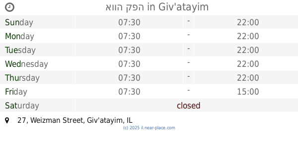
אווה קפה
Weizman Street 27, Giv'atayim
Cafe
Food
Point of interest
Establishment
read more
1.007 km
BREGO מקורות קפה
שדרות ירושלים 43, רמת גן
Cafe
read more
1.052 km
קפה אג'נדה
HaBanim Street 18, Ramat Gan
Cafe
read more
1.052 km
קפה אג'נדה
הבנים 18, רמת גן
Cafe
read more
📑
all categories
Accounting
Administrative area level 1
Administrative area level 2
Airport
Amusement park
Aquarium
Art gallery
Atm
Bakery
Bank
Bar
Beauty salon
Bicycle store
Book store
Bowling alley
Bus station
Cafe
Campground
Car dealer
Car rental
Car repair
Car wash
Casino
Cemetery
Church
City hall
Clothing store
Colloquial area
Convenience store
Country
Courthouse
Dentist
Department store
Doctor
Electrician
Electronics store
Embassy
Establishment
Finance
Fire station
Florist
Food
Funeral home
Furniture store
Gas station
General contractor
Grocery or supermarket
Gym
Hair care
Hardware store
Health
Hindu Temple
Home goods store
Hospital
Insurance agency
Intersection
Jewelry store
Laundry
Lawyer
Library
Light rail station
Liquor store
Local government office
Locality
Locksmith
Lodging
Meal delivery
Meal takeaway
Mosque
Movie rental
Movie theater
Moving company
Museum
Natural feature
Neighborhood
Night club
Painter
Park
Parking
Pet store
Pharmacy
Physiotherapist
Place of worship
Plumber
Point of interest
Police
Political
Post office
Premise
Real estate agency
Restaurant
Roofing contractor
Route
Rv park, camping
School
Shoe store
Shopping mall
Spa
Stadium
Storage
Store
Subpremise
Subway station
Supermarket
Synagogue
Taxi stand
Train station
Transit station
Travel agency
University
Veterinary care
Zoo
administrative area level 3
administrative area level 4
sublocality level 1
↑