University nearby המכון לחקר הבנייה
Israel
University nearby המכון לחקר הבנייה
המכון לחקר הבנייה
חיפה, ישראל
contacts phone
:
+972
website:
nbri.net.technion.ac.il
Latitude:
32.7792298
, Longitude:
35.0213462
larger map & directions
read more
nearest University
125 m
הנדסת גאודזיה
חיפה
University
read more
200 m
Home for Children
Haifa
University
read more
240 m
Psychological Services
Haifa
University
read more
245 m
Dorothy and Martin Kellner Amphitheater
Haifa
University
read more
286 m
בית הספר ללימודי מוסמכים בטכניון
חיפה
University
read more
288 m
Alpert Employees Center
Haifa
University
read more
319 m
Technion
Haifa
University
read more
319 m
Технологический институт Текнион - Израиль
Haifa
University
read more
319 m
הטכניון - מכון טכנולוגי לישראל
חיפה
University
read more
345 m
מעונות נווה דוהט ארהב
חיפה
University
read more
375 m
מעונות הסנאט
חיפה
University
read more
530 m
Chemistry Biology Library
Haifa
University
read more
587 m
Mechanical Engineering
הטכניון, חיפה
University
read more
602 m
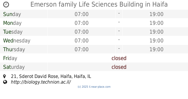
Emerson family Life Sciences Building
Sderot David Rose 21, Haifa
University
read more
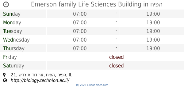
602 m
Emerson family Life Sciences Building
שדרות דוד רוז 21, חיפה
University
read more
609 m
Faculty of Education Science and Technology
Haifa
University
read more
636 m
מרכז מבקרים קליפורניה קולר
חיפה
University
read more
673 m
Continuing Education Department
Haifa
University
read more
683 m
הטכניון – היחידה ללימודי המשך ולימודי חוץ עש עזריאלי
Canada Building, Haifa
University
read more
690 m
מעבדות אווירונאוטיקה
חיפה
University
read more
725 m
המרכז להנעה רקטית
חיפה
University
read more
725 m
Ignition Laboratories
Haifa
University
read more
776 m
Ha-Kfar Ha-Mizrakhi Dormitories
Haifa
University
read more
788 m
Heller Center
הטכניון חיפה, חיפה
University
read more
881 m
Technion engineers
Zahal Street 13, Nesher
University
read more
📑
all categories
Accounting
Administrative area level 1
Administrative area level 2
Airport
Amusement park
Aquarium
Art gallery
Atm
Bakery
Bank
Bar
Beauty salon
Bicycle store
Book store
Bowling alley
Bus station
Cafe
Campground
Car dealer
Car rental
Car repair
Car wash
Casino
Cemetery
Church
City hall
Clothing store
Colloquial area
Convenience store
Country
Courthouse
Dentist
Department store
Doctor
Electrician
Electronics store
Embassy
Establishment
Finance
Fire station
Florist
Food
Funeral home
Furniture store
Gas station
General contractor
Grocery or supermarket
Gym
Hair care
Hardware store
Health
Hindu Temple
Home goods store
Hospital
Insurance agency
Intersection
Jewelry store
Laundry
Lawyer
Library
Light rail station
Liquor store
Local government office
Locality
Locksmith
Lodging
Meal delivery
Meal takeaway
Mosque
Movie rental
Movie theater
Moving company
Museum
Natural feature
Neighborhood
Night club
Painter
Park
Parking
Pet store
Pharmacy
Physiotherapist
Place of worship
Plumber
Point of interest
Police
Political
Post office
Premise
Real estate agency
Restaurant
Roofing contractor
Route
Rv park, camping
School
Shoe store
Shopping mall
Spa
Stadium
Storage
Store
Subpremise
Subway station
Supermarket
Synagogue
Taxi stand
Train station
Transit station
Travel agency
University
Veterinary care
Zoo
administrative area level 3
administrative area level 4
sublocality level 1
↑