Synagogue nearby Yeshu'at Yisrael Synagogue
Israel
Synagogue nearby Yeshu'at Yisrael Synagogue
Yeshu'at Yisrael Synagogue
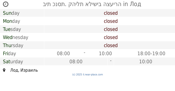
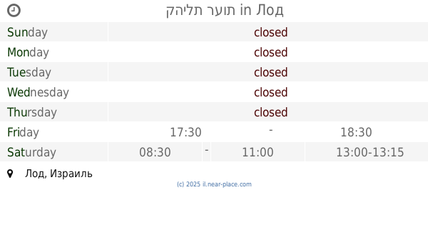
Лод, Израиль
contacts phone
:
+972
Latitude:
31.9539953
, Longitude:
34.8989464
larger map & directions
read more
nearest Synagogue
184 m
Sha'arei Shamaim Synagogue
Lod
Synagogue
read more
184 m
בית כנסת בית אליהו
לוד
Synagogue
read more
264 m
Abir Ya'akov Synagogue
Lod
Synagogue
read more
302 m
Synagogue salvation of God
Lod
Synagogue
read more
338 m
בית כנסת התנא רבי שמעון בר יוחאי
לוד
Synagogue
read more
367 m
בית הכנסת שומרי ישראל
לוד
Synagogue
read more
367 m
Shomrei Israel Synagogue
Lod
Synagogue
read more
424 m
Dossa synagogue
21,, He-Khaluts Street 19, Lod
Synagogue
read more
424 m
בית כנסת דוסא
21,, He-Khaluts Street 19, Lod
Synagogue
read more
473 m
Sha'arei Aliya Synagogue
Lod
Synagogue
read more
481 m
בית הכנסת חבד
לוד
Synagogue
read more
560 m
בית כנסת. קהילת אלישיב הצעירה
Lod
Synagogue
read more
597 m
Ha-Rama Synagogue
Lod
Synagogue
read more
597 m
בית כנסת הרמא
לוד
Synagogue
read more
614 m
קהילת רעות
Lod
Synagogue
read more
658 m
בית הכנסת ישורון
לוד
Synagogue
read more
722 m
Beautiful scenery synagogue
Aseret Harugei Malhut Street, Lod
Synagogue
read more
722 m
בית הכנסת יפה נוף
עשרת הרוגי מלכות, לוד
Synagogue
read more
752 m
בית כנסת היכל יעקב
הנרייטה סולד 114, לוד
Synagogue
read more
820 m
בית כנסת בית ישראל
Sderot Shlomo HaMelech 105, Lod
Synagogue
read more
823 m
בית כנסת תפארת ישראל
Derekh Mishmar Nof 1, Lod
Synagogue
read more
942 m
Torah synagogue I-Light
Ha-Nasi Street, Lod
Synagogue
read more
957 m
בית הכנסת מגן דוד
לוד
Synagogue
read more
957 m
בית הכנסת מגן דוד
Lod
Synagogue
read more
1.044 km
בית הכנסת שארית ישראל הוסטל
חיים משה שפירא 25, לוד
Synagogue
read more
📑
all categories
Accounting
Administrative area level 1
Administrative area level 2
Airport
Amusement park
Aquarium
Art gallery
Atm
Bakery
Bank
Bar
Beauty salon
Bicycle store
Book store
Bowling alley
Bus station
Cafe
Campground
Car dealer
Car rental
Car repair
Car wash
Casino
Cemetery
Church
City hall
Clothing store
Colloquial area
Convenience store
Country
Courthouse
Dentist
Department store
Doctor
Electrician
Electronics store
Embassy
Establishment
Finance
Fire station
Florist
Food
Funeral home
Furniture store
Gas station
General contractor
Grocery or supermarket
Gym
Hair care
Hardware store
Health
Hindu Temple
Home goods store
Hospital
Insurance agency
Intersection
Jewelry store
Laundry
Lawyer
Library
Light rail station
Liquor store
Local government office
Locality
Locksmith
Lodging
Meal delivery
Meal takeaway
Mosque
Movie rental
Movie theater
Moving company
Museum
Natural feature
Neighborhood
Night club
Painter
Park
Parking
Pet store
Pharmacy
Physiotherapist
Place of worship
Plumber
Point of interest
Police
Political
Post office
Premise
Real estate agency
Restaurant
Roofing contractor
Route
Rv park, camping
School
Shoe store
Shopping mall
Spa
Stadium
Storage
Store
Subpremise
Subway station
Supermarket
Synagogue
Taxi stand
Train station
Transit station
Travel agency
University
Veterinary care
Zoo
administrative area level 3
administrative area level 4
sublocality level 1
↑