Synagogue nearby ויען שמואל
Israel
Synagogue nearby ויען שמואל
ויען שמואל
Yitskhak David Man Street 7, Jerusalem Izrael
contacts phone
:
+972
Latitude:
31.7607114
, Longitude:
35.1984398
read more
nearest Synagogue
59 m
Ohel Moshe Synagogue for North African Jewry
Jerusalem
Synagogue
read more
151 m
משכן שמואל
Ha-Rav Gold Street 8, Jerusalem
Synagogue
read more
151 m
משכן שמואל
הרב גולד 8, ירושלים
Synagogue
read more
160 m
Chabad Givat Mordechai
Ha-Rav Gold Street 6, Jerusalem
Synagogue
read more
364 m
היכל הפיס לנוער- בית הכנסת צדק תורה בציון
Nikkanor Street, Jerusalem
Synagogue
read more
396 m
בית כנסת חברון
Masat Moshe Street 4, Jerusalem
Synagogue
read more
436 m
שטיבלך
10, Ha-Rav Khayim Heler Street 6, Jerusalem
Synagogue
read more
438 m
Nahar ha-Metaher Synagogue
Jerusalem
Synagogue
read more
552 m
בית חבד קטמון-גוננים
קנאי הגליל 4, ירושלים
Synagogue
read more
624 m
קהילת מבקשי דרך
שדרות ש"י עגנון 22, ירושלים
Synagogue
read more
677 m
Beit Yosef Synagogue
Jerusalem
Synagogue
read more
712 m
בית כנסת המרכזי הצריף
יצחק שדה 1, ירושלים
Synagogue
read more
747 m
ביכ גאולה
ירושלים
Synagogue
read more
816 m
Am Ram Synagogue
Jerusalem
Synagogue
read more
826 m
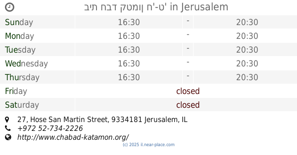
בית חבד קטמון ח'-ט'
חוזה סן מרטין 27, ירושלים
Synagogue
read more
826 m
בית חבד קטמון ח'-ט'
Hose San Martin Street 27, Jerusalem
Synagogue
read more
893 m
Ozer Dalim Synagogue
Ha-Khish Street 16, Jerusalem
Synagogue
read more
893 m
בית כנסת עוזר דלים
החי"ש 16, ירושלים
Synagogue
read more
899 m
Shtiblach Synagogue
Ha-Khish Street 14, Jerusalem
Synagogue
read more
908 m
Keter Tora Synagogue
Jerusalem
Synagogue
read more
916 m
Beth Annaelle v'Yisrael
Yosef Khakhami Street 26, Jerusalem
Synagogue
read more
941 m
ביכ היכל יעקב
ירושלים
Synagogue
read more
942 m
Beit Yehudah Synagogue
Jerusalem
Synagogue
read more
970 m
Or Yesharim Synagogue
Jerusalem
Synagogue
read more
1.134 km
בית כנסת תפארת אליהו
Rashbag Street 39, Jerusalem
Synagogue
read more
📑
all categories
Accounting
Administrative area level 1
Administrative area level 2
Airport
Amusement park
Aquarium
Art gallery
Atm
Bakery
Bank
Bar
Beauty salon
Bicycle store
Book store
Bowling alley
Bus station
Cafe
Campground
Car dealer
Car rental
Car repair
Car wash
Casino
Cemetery
Church
City hall
Clothing store
Colloquial area
Convenience store
Country
Courthouse
Dentist
Department store
Doctor
Electrician
Electronics store
Embassy
Establishment
Finance
Fire station
Florist
Food
Funeral home
Furniture store
Gas station
General contractor
Grocery or supermarket
Gym
Hair care
Hardware store
Health
Hindu Temple
Home goods store
Hospital
Insurance agency
Intersection
Jewelry store
Laundry
Lawyer
Library
Light rail station
Liquor store
Local government office
Locality
Locksmith
Lodging
Meal delivery
Meal takeaway
Mosque
Movie rental
Movie theater
Moving company
Museum
Natural feature
Neighborhood
Night club
Painter
Park
Parking
Pet store
Pharmacy
Physiotherapist
Place of worship
Plumber
Point of interest
Police
Political
Post office
Premise
Real estate agency
Restaurant
Roofing contractor
Route
Rv park, camping
School
Shoe store
Shopping mall
Spa
Stadium
Storage
Store
Subpremise
Subway station
Supermarket
Synagogue
Taxi stand
Train station
Transit station
Travel agency
University
Veterinary care
Zoo
administrative area level 3
administrative area level 4
sublocality level 1
↑