Synagogue nearby אוהל לוי יצחק
Israel
Synagogue nearby אוהל לוי יצחק
אוהל לוי יצחק
1, תור, ערד, באר שבע, IL ישראל
contacts phone
:
+972
Latitude:
31.2686943
, Longitude:
35.2124611
larger map & directions
read more
nearest Synagogue
אוהל לוי יצחק
Tor Street 1, Arad
Synagogue
read more
153 m
בית הכנסת הספרדי בית אל
ערד
Synagogue
read more
153 m
בית הכנסת הספרדי בית אל
Arad
Synagogue
read more
562 m
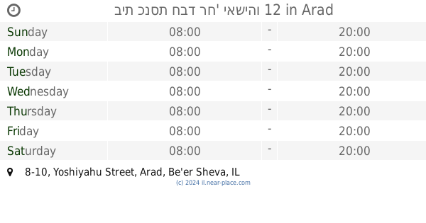
בית כנסת חבד רח' יאשיהו 12
Yoshiyahu Street 8-10, Arad
Synagogue
read more
859 m
בית הכנסת הספרדי המרכזי
ערד
Synagogue
read more
859 m
Sephardic Synagogue
Arad
Synagogue
read more
1000 m
בית הכנסת תפארת ישראל
אלעזר בן יאיר 11, ערד
Synagogue
read more
1000 m
בית הכנסת תפארת ישראל
Elazar Ben Ya'ir Street 11, Arad
Synagogue
read more
1.111 km
בית כנסת ספרדי
צבעוני 1-27, ערד
Synagogue
read more
1.111 km
בית כנסת ספרדי
Tsiv'oni Street 1-27, Arad
Synagogue
read more
1.179 km
Ashkenazi Synagogue
Arad
Synagogue
read more
1.189 km
אהבת ישראל
הקנאים 35, ערד
Synagogue
read more
1.194 km
בית הכנסת אמיר שאול
Egoz Street 8, Arad
Synagogue
read more
1.248 km
בית כנסת השחר
ערד
Synagogue
read more
1.266 km
בית הכנסת שבת אחים
ערד
Synagogue
read more
1.283 km
בית כנסת שירה חדשה
ערד
Synagogue
read more
1.33 km
Ateret Zvi Synagogue
Ha-Maccabim Street 20, Arad
Synagogue
read more
1.353 km
בית הכנסת בית רחמים
Shim'on Street 42, Arad
Synagogue
read more
1.379 km
בית הכנסת בית יום טוב ליפמן
Hen Street 40, Arad
Synagogue
read more
1.393 km
בית יצחק דוד
Etrog Street 31, Arad
Synagogue
read more
1.794 km
בית כנסת רשב"י
הפלמ"ח 37 א, ערד
Synagogue
read more
1.794 km
בית כנסת רשב"י
הפלמ"ח 37 א, Arad
Synagogue
read more
2.123 km
אמיר איפרגן אלישי ברסט
-39, Eshed Street 19, Arad
Synagogue
read more
2.246 km
Captivating Israel Synagogue
Arad
Synagogue
read more
2.246 km
בית הכנסת שובה ישראל
ערד
Synagogue
read more
📑
all categories
Accounting
Administrative area level 1
Administrative area level 2
Airport
Amusement park
Aquarium
Art gallery
Atm
Bakery
Bank
Bar
Beauty salon
Bicycle store
Book store
Bowling alley
Bus station
Cafe
Campground
Car dealer
Car rental
Car repair
Car wash
Casino
Cemetery
Church
City hall
Clothing store
Colloquial area
Convenience store
Country
Courthouse
Dentist
Department store
Doctor
Electrician
Electronics store
Embassy
Establishment
Finance
Fire station
Florist
Food
Funeral home
Furniture store
Gas station
General contractor
Grocery or supermarket
Gym
Hair care
Hardware store
Health
Hindu Temple
Home goods store
Hospital
Insurance agency
Intersection
Jewelry store
Laundry
Lawyer
Library
Light rail station
Liquor store
Local government office
Locality
Locksmith
Lodging
Meal delivery
Meal takeaway
Mosque
Movie rental
Movie theater
Moving company
Museum
Natural feature
Neighborhood
Night club
Painter
Park
Parking
Pet store
Pharmacy
Physiotherapist
Place of worship
Plumber
Point of interest
Police
Political
Post office
Premise
Real estate agency
Restaurant
Roofing contractor
Route
Rv park, camping
School
Shoe store
Shopping mall
Spa
Stadium
Storage
Store
Subpremise
Subway station
Supermarket
Synagogue
Taxi stand
Train station
Transit station
Travel agency
University
Veterinary care
Zoo
administrative area level 3
administrative area level 4
sublocality level 1
↑