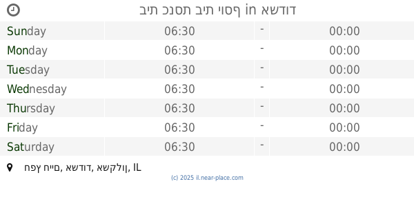
Synagogue nearby Western candle synagogue
Israel
Synagogue nearby Western candle synagogue
Western candle synagogue
9, Hativat HaNegev Street, Ashdod, Ashkelon, IL Израиль
contacts phone
:
+972 54-485-2388
Latitude:
31.8029926
, Longitude:
34.6638657
larger map & directions
read more
nearest Synagogue
108 m
בית כנסת נר מערבי
חטיבת הנגב 9, אשדוד
Synagogue
read more
108 m
Synagogue Western Lamp
Hativat HaNegev Street 9, Ashdod
Synagogue
read more
109 m
בית כנסת אור שלמה בעלזא
חטיבת הנגב, אשדוד
Synagogue
read more
226 m
Synagogue - to
Ashdod
Synagogue
read more
355 m
ביכ נתיבי החיים
Ha-Rav Shmuel Rozovsky Street 5, Ashdod
Synagogue
read more
355 m
בי"כ נתיבי החיים
הרב שמואל רוזובסקי 5, אשדוד
Synagogue
read more
405 m
בית כנסת מורשה
Ha-Rav Shmuel Rozovsky Street, Ashdod
Synagogue
read more
452 m
בית כנסת לעולי הודו קהילת בני ישראל
קרית אברמסקי, מרכז מסחרי,רח' שמואל רוזובסקי, אשדוד
Synagogue
read more
546 m
Swieca Hall
Ashdod
Synagogue
read more
661 m
בית הכנסת חבד
רבי עקיבא 4, אשדוד
Synagogue
read more
664 m
Ashdod Yeshiva Synagogue
Rabi Akiva Street 6, Ashdod
Synagogue
read more
754 m
בית כנסת בית יוסף
Khafets Khayim Street, Ashdod
Synagogue
read more
754 m
בית כנסת בית יוסף
חפץ חיים, אשדוד
Synagogue
read more
775 m
בית הכנסת אליהו הנביא
חפץ חיים 13, אשדוד
Synagogue
read more
832 m
ישיבת פיטסבורג
צדקת יוסף 1, אשדוד
Synagogue
read more
885 m
היכל דוד
אשדוד
Synagogue
read more
885 m
היכל דוד
Ashdod
Synagogue
read more
891 m
The synagogue Nasciz
Rabbi Eliezer Ben Horkanos 31, Ashdod
Synagogue
read more
953 m
בית כנסת שבטי ישראל
Ashdod
Synagogue
read more
983 m
Sing Isaac Synagogue
Ashdod
Synagogue
read more
1.169 km
לב יצחק
Tsizling Street 9, Ashdod
Synagogue
read more
1.169 km
מרכז תורני "לב יצחק"
Tsizling Street 9, Ashdod
Synagogue
read more
1.219 km
Rema Synagogue
Ashdod
Synagogue
read more
1.343 km
בית הכנסת היכל אירית
אשדוד
Synagogue
read more
1.343 km
בית הכנסת היכל אירית
Ashdod
Synagogue
read more
📑
all categories
Accounting
Administrative area level 1
Administrative area level 2
Airport
Amusement park
Aquarium
Art gallery
Atm
Bakery
Bank
Bar
Beauty salon
Bicycle store
Book store
Bowling alley
Bus station
Cafe
Campground
Car dealer
Car rental
Car repair
Car wash
Casino
Cemetery
Church
City hall
Clothing store
Colloquial area
Convenience store
Country
Courthouse
Dentist
Department store
Doctor
Electrician
Electronics store
Embassy
Establishment
Finance
Fire station
Florist
Food
Funeral home
Furniture store
Gas station
General contractor
Grocery or supermarket
Gym
Hair care
Hardware store
Health
Hindu Temple
Home goods store
Hospital
Insurance agency
Intersection
Jewelry store
Laundry
Lawyer
Library
Light rail station
Liquor store
Local government office
Locality
Locksmith
Lodging
Meal delivery
Meal takeaway
Mosque
Movie rental
Movie theater
Moving company
Museum
Natural feature
Neighborhood
Night club
Painter
Park
Parking
Pet store
Pharmacy
Physiotherapist
Place of worship
Plumber
Point of interest
Police
Political
Post office
Premise
Real estate agency
Restaurant
Roofing contractor
Route
Rv park, camping
School
Shoe store
Shopping mall
Spa
Stadium
Storage
Store
Subpremise
Subway station
Supermarket
Synagogue
Taxi stand
Train station
Transit station
Travel agency
University
Veterinary care
Zoo
administrative area level 3
administrative area level 4
sublocality level 1
↑