Synagogue nearby Ohel Moshe Synagogue
Israel
Synagogue nearby Ohel Moshe Synagogue
Ohel Moshe Synagogue
6, Gordon Street, Giv'atayim, IL Израиль
contacts phone
:
+972
Latitude:
32.0760364
, Longitude:
34.8069936
larger map & directions
read more
nearest Synagogue
291 m
Tur Sinai Synagogue
Giv'atayim
Synagogue
read more
291 m
Synagogue Beth El
Giv'atayim
Synagogue
read more
297 m
בית הכנסת בית רמבם
הפועל הצעיר 14, גבעתיים
Synagogue
read more
360 m
Tiferet Israel Synagogue
Giv'atayim
Synagogue
read more
464 m
בית-כנסת בית אל
גבעתיים
Synagogue
read more
513 m
בית-הכנסת הרמבם
רח. רותם, גבעתיים
Synagogue
read more
517 m
בית הכנסת היכל משה
Giv'atayim
Synagogue
read more
519 m
Synagogue faith Mordechai Givatayim
Tsahal Street 7, Giv'atayim
Synagogue
read more
590 m
בית הכנסת נחלת יצחק
עמק ברכה 48, תל אביב יפו
Synagogue
read more
623 m
בית הכנסת עין יעקב גבעתיים
Sheinkin Street 43, Giv'atayim
Synagogue
read more
642 m
בית הכנסת סיני
לאן 27, רמת גן
Synagogue
read more
679 m
Ha-Admor mi-Shtefnashet Tomb
Giv'atayim
Synagogue
read more
773 m
בית הכנסת התחיה
Sderot Nehama, Ramat Gan
Synagogue
read more
818 m
Temple Beth Eliyahu
Giv'atayim
Synagogue
read more
930 m
בית כנסת המרכזי לספרדים
הנגיד 2, רמת גן
Synagogue
read more
980 m
בית חבד גבעתיים
כצנלסון 145, גבעתיים
Synagogue
read more
990 m
בית כנסת שובו אחים
תוצרת הארץ 7, תל אביב יפו
Synagogue
read more
998 m
בית הכנסת שובו אחים
תוצרת הארץ 7, תל אביב יפו
Synagogue
read more
1.048 km
בית כנסת אוהל שם
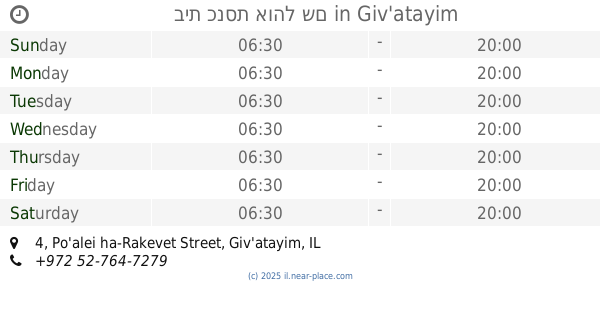
Po'alei ha-Rakevet Street 4, Giv'atayim
Synagogue
read more
1.1 km
בית כנסת תימני אור החיים
Plitei HaSfar Street 6, Tel Aviv-Yafo
Synagogue
read more
1.132 km
מגדל עוז
הדמומית 18, תל אביב יפו
Synagogue
read more
1.137 km
בית הכנסת הגדול רמת גן
Herzl Street 47, Ramat Gan
Synagogue
read more
1.137 km
בית הכנסת הגדול רמת גן
הרצל 47, רמת גן
Synagogue
read more
1.284 km
היכל עמישדי
4,, Fabregat Street 2, Ramat Gan
Synagogue
read more
1.291 km
Shivtei Israel Synagogue
Derech Ben Gurion 243, Ramat Gan
Synagogue
read more
📑
all categories
Accounting
Administrative area level 1
Administrative area level 2
Airport
Amusement park
Aquarium
Art gallery
Atm
Bakery
Bank
Bar
Beauty salon
Bicycle store
Book store
Bowling alley
Bus station
Cafe
Campground
Car dealer
Car rental
Car repair
Car wash
Casino
Cemetery
Church
City hall
Clothing store
Colloquial area
Convenience store
Country
Courthouse
Dentist
Department store
Doctor
Electrician
Electronics store
Embassy
Establishment
Finance
Fire station
Florist
Food
Funeral home
Furniture store
Gas station
General contractor
Grocery or supermarket
Gym
Hair care
Hardware store
Health
Hindu Temple
Home goods store
Hospital
Insurance agency
Intersection
Jewelry store
Laundry
Lawyer
Library
Light rail station
Liquor store
Local government office
Locality
Locksmith
Lodging
Meal delivery
Meal takeaway
Mosque
Movie rental
Movie theater
Moving company
Museum
Natural feature
Neighborhood
Night club
Painter
Park
Parking
Pet store
Pharmacy
Physiotherapist
Place of worship
Plumber
Point of interest
Police
Political
Post office
Premise
Real estate agency
Restaurant
Roofing contractor
Route
Rv park, camping
School
Shoe store
Shopping mall
Spa
Stadium
Storage
Store
Subpremise
Subway station
Supermarket
Synagogue
Taxi stand
Train station
Transit station
Travel agency
University
Veterinary care
Zoo
administrative area level 3
administrative area level 4
sublocality level 1
↑