Synagogue nearby בית כנסת אשל הנשיא
Israel
Synagogue nearby בית כנסת אשל הנשיא
בית כנסת אשל הנשיא
אשל הנשיא ישראל
contacts phone
:
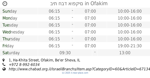
+972
Latitude:
31.3256334
, Longitude:
34.6975387
read more
nearest Synagogue
בית כנסת אשל הנשיא
Eshel HaNasi
Synagogue
read more
1.032 km
בית כנסת בית יוסף
בית יוסף, תפרח
Synagogue
read more
1.882 km
ישיבת תושיה תפרח
HaYeshiva Street, Tifrah
Synagogue
read more
1.882 km
ישיבת תושיה תפרח
הישיבה, תפרח
Synagogue
read more
2.136 km
בית הכנסת אהל יעקב וחיה
43, Rambam Street 41, Tifrah
Synagogue
read more
4.481 km
בית הכנסת שערי ברכה
Gilat
Synagogue
read more
4.481 km
בית הכנסת שערי ברכה
גילת
Synagogue
read more
8.408 km
בית חבד אופקים
Ha-Khita Street 1, Ofakim
Synagogue
read more
9.292 km
Synagogue Honi
Be'er Sheva
Synagogue
read more
9.746 km
Mordechai Synagogue
Be'er Sheva
Synagogue
read more
10.135 km
בית כנסת עטרת שלמה
באר שבע
Synagogue
read more
10.733 km
Isaac Synagogue Beit Yitzhak Alush Gblli
Be'er Sheva
Synagogue
read more
10.882 km
רינת ירושלים.
הצבי 129, באר שבע
Synagogue
read more
10.915 km
בית הכנסת רבי דוד בן ברוך
Be'er Sheva
Synagogue
read more
11.078 km
Ha-Kippa Synogogue
HaTsvi Street 40, Be'er Sheva
Synagogue
read more
11.328 km
Oz ve'Ta'atzumot Synagogue
Be'er Sheva
Synagogue
read more
11.81 km
בית הכנסת זכור לאברהם
Be'er Sheva
Synagogue
read more
11.913 km
בית הכנסת תפארת להבים
להבים
Synagogue
read more
12.116 km
Sinai Synagogue
Be'er Sheva
Synagogue
read more
12.768 km
בית כנסת כתר תורה
באר שבע
Synagogue
read more
12.834 km
בית כנסת-מגן אברהם
באר שבע
Synagogue
read more
12.922 km
בית הכנסת שער השמײם
באר שבע
Synagogue
read more
13.815 km
בית כנסת עץ החיים
Sheizaf Street 2-18, Be'er Sheva
Synagogue
read more
14.858 km
בית כנסת אהבת חיים
נתיבות
Synagogue
read more
16.169 km
Synagogue Residence woods
Alon Street, Netivot
Synagogue
read more
📑
all categories
Accounting
Administrative area level 1
Administrative area level 2
Airport
Amusement park
Aquarium
Art gallery
Atm
Bakery
Bank
Bar
Beauty salon
Bicycle store
Book store
Bowling alley
Bus station
Cafe
Campground
Car dealer
Car rental
Car repair
Car wash
Casino
Cemetery
Church
City hall
Clothing store
Colloquial area
Convenience store
Country
Courthouse
Dentist
Department store
Doctor
Electrician
Electronics store
Embassy
Establishment
Finance
Fire station
Florist
Food
Funeral home
Furniture store
Gas station
General contractor
Grocery or supermarket
Gym
Hair care
Hardware store
Health
Hindu Temple
Home goods store
Hospital
Insurance agency
Intersection
Jewelry store
Laundry
Lawyer
Library
Light rail station
Liquor store
Local government office
Locality
Locksmith
Lodging
Meal delivery
Meal takeaway
Mosque
Movie rental
Movie theater
Moving company
Museum
Natural feature
Neighborhood
Night club
Painter
Park
Parking
Pet store
Pharmacy
Physiotherapist
Place of worship
Plumber
Point of interest
Police
Political
Post office
Premise
Real estate agency
Restaurant
Roofing contractor
Route
Rv park, camping
School
Shoe store
Shopping mall
Spa
Stadium
Storage
Store
Subpremise
Subway station
Supermarket
Synagogue
Taxi stand
Train station
Transit station
Travel agency
University
Veterinary care
Zoo
administrative area level 3
administrative area level 4
sublocality level 1
↑