Synagogue nearby בית כנסת
Israel
Synagogue nearby בית כנסת
בית כנסת
Рамат-Ган, Израиль
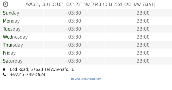
contacts phone
:
+972
Latitude:
32.0464901
, Longitude:
34.8340731
larger map & directions
read more
nearest Synagogue
בית כנסת
רמת גן
Synagogue
read more
1.43 km
אור ישרים
האם 14, רמת גן
Synagogue
read more
1.43 km
אור ישרים
HaEm Street 14, Ramat Gan
Synagogue
read more
1.456 km
Hazon Ovadia Synagogue
HaEm Street 2, Ramat Gan
Synagogue
read more
1.583 km
בית כנסת אהבה ואחוה
Ramat Gan
Synagogue
read more
1.583 km
בית כנסת אהבה ואחוה
רמת גן
Synagogue
read more
1.584 km
הדר קודש
נווה יהושע 39, רמת גן
Synagogue
read more
1.629 km
משכנות יעקב
Arnon Street 13, Ramat Gan
Synagogue
read more
1.629 km
משכנות יעקב
ארנון 13, רמת גן
Synagogue
read more
1.687 km
אהל גבריאל
אחד העם 10, רמת גן
Synagogue
read more
1.699 km
Ohel Shimon
Ha-Biluyim Street 44, Ramat Gan
Synagogue
read more
1.7 km
בית הכנסת למען שמו באהבה
גילדסגיים 12, רמת גן
Synagogue
read more
1.875 km
בית הכנסת דובב עוז
הביל"ויים 21, רמת גן
Synagogue
read more
1.9 km
היכל הנס
HaTayasim Road 39, Ramat Gan
Synagogue
read more
1.915 km
בית הכנסת ישראל הצעיר
המשורר יעקב כהן 27, רמת גן
Synagogue
read more
1.934 km
בית הכנסת ישורון
רמת גן
Synagogue
read more
1.949 km
ישיבה, בית כנסת ובית מדרש לאברכים מצויינים עש הגאון רבנו יוסף חיים זיעא
Lod Road, Tel Aviv-Yafo
Synagogue
read more
2.007 km
בית כנסת .יגדיל תורה
Herzl Street 17, Or Yehuda
Synagogue
read more
2.043 km
בית הכנסת "משכנות ישראל"- מניין צעירים
Brodetski Street 8, Ramat Gan
Synagogue
read more
2.083 km
Synagogue Residence Shemayah
Or Yehuda
Synagogue
read more
2.181 km
בית הכנסת גבורות מרדכי
HaRav Herzog Street 34, Giv'atayim
Synagogue
read more
2.55 km
בית הכנסת המרכזי
קרית אונו
Synagogue
read more
2.563 km
Synagogue Eli Cohen
Ha-Rishonim Street 60, Or Yehuda
Synagogue
read more
2.574 km
בית הכנסת זכרון קדושים
גבעתיים
Synagogue
read more
2.574 km
Synagogue holy memory
Giv'atayim
Synagogue
read more
📑
all categories
Accounting
Administrative area level 1
Administrative area level 2
Airport
Amusement park
Aquarium
Art gallery
Atm
Bakery
Bank
Bar
Beauty salon
Bicycle store
Book store
Bowling alley
Bus station
Cafe
Campground
Car dealer
Car rental
Car repair
Car wash
Casino
Cemetery
Church
City hall
Clothing store
Colloquial area
Convenience store
Country
Courthouse
Dentist
Department store
Doctor
Electrician
Electronics store
Embassy
Establishment
Finance
Fire station
Florist
Food
Funeral home
Furniture store
Gas station
General contractor
Grocery or supermarket
Gym
Hair care
Hardware store
Health
Hindu Temple
Home goods store
Hospital
Insurance agency
Intersection
Jewelry store
Laundry
Lawyer
Library
Light rail station
Liquor store
Local government office
Locality
Locksmith
Lodging
Meal delivery
Meal takeaway
Mosque
Movie rental
Movie theater
Moving company
Museum
Natural feature
Neighborhood
Night club
Painter
Park
Parking
Pet store
Pharmacy
Physiotherapist
Place of worship
Plumber
Point of interest
Police
Political
Post office
Premise
Real estate agency
Restaurant
Roofing contractor
Route
Rv park, camping
School
Shoe store
Shopping mall
Spa
Stadium
Storage
Store
Subpremise
Subway station
Supermarket
Synagogue
Taxi stand
Train station
Transit station
Travel agency
University
Veterinary care
Zoo
administrative area level 3
administrative area level 4
sublocality level 1
↑