Synagogue nearby בית כנסת אנשי יושר
Israel
Synagogue nearby בית כנסת אנשי יושר
בית כנסת אנשי יושר
7, Nakhshon Street, Ness Ziona, Rehovot, IL Израиль
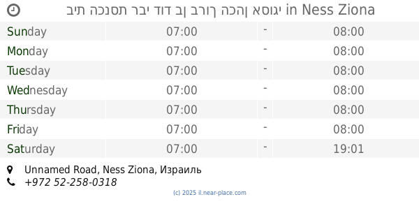
contacts phone
:
+972
Latitude:
31.9365651
, Longitude:
34.8071542
larger map & directions
read more
nearest Synagogue
31 m
בית הכנסת עזרא הסופר
נס ציונה
Synagogue
read more
32 m
בן פורת יוסף
Nakhshon Street 7, Ness Ziona
Synagogue
read more
168 m
David ha-Melekh Synagogue
Ness Ziona
Synagogue
read more
186 m
בית כנסת עזרת אחים
Ness Ziona
Synagogue
read more
186 m
Ezrat Ahim Synagogue
Ness Ziona
Synagogue
read more
401 m
שבת אחים
גולי דמשק 8, נס ציונה
Synagogue
read more
413 m
The synagogue Thread
Ness Ziona
Synagogue
read more
432 m
משכן ישראל
Golei Damesek Street 9, Ness Ziona
Synagogue
read more
474 m
Synagogue and Rayak
Ness Ziona
Synagogue
read more
474 m
בית כנסת וריאק
נס ציונה
Synagogue
read more
502 m
בית הכנסת רבי דוד בן ברוך הכהן אסוגי
Unnamed Road, נס ציונה
Synagogue
read more
502 m
בית הכנסת רבי דוד בן ברוך הכהן אסוגי
Unnamed Road, Ness Ziona
Synagogue
read more
528 m
בית כנסת רמבם
צה"ל 46, נס ציונה
Synagogue
read more
545 m
אהל יעקב
גולומב 21, נס ציונה
Synagogue
read more
545 m
אהל יעקב
Golomb Street 21, Ness Ziona
Synagogue
read more
554 m
בית כנסת אגודת ישרים
HaThiya Street, Ness Ziona
Synagogue
read more
564 m
בית כנסת עש רבי שלום שבזי
Ness Ziona
Synagogue
read more
564 m
Shalom Shabazi Synagogue
Ness Ziona
Synagogue
read more
564 m
בית כנסת עש רבי שלום שבזי
נס ציונה
Synagogue
read more
823 m
סוכת שלמה
Ha-Narkis Street 4, Ness Ziona
Synagogue
read more
823 m
סוכת שלמה
הנרקיס 4, נס ציונה
Synagogue
read more
1.221 km
בית חב״ד נס ציונה
ביאליק 2, נס ציונה
Synagogue
read more
1.221 km
בית חבד
Bialik Street 2, Ness Ziona
Synagogue
read more
1.221 km
Chabad House
Bialik Street 2, Ness Ziona
Synagogue
read more
1.221 km
Chabad of Ness Ziona
Bialik Street 2, Ness Ziona
Synagogue
read more
📑
all categories
Accounting
Administrative area level 1
Administrative area level 2
Airport
Amusement park
Aquarium
Art gallery
Atm
Bakery
Bank
Bar
Beauty salon
Bicycle store
Book store
Bowling alley
Bus station
Cafe
Campground
Car dealer
Car rental
Car repair
Car wash
Casino
Cemetery
Church
City hall
Clothing store
Colloquial area
Convenience store
Country
Courthouse
Dentist
Department store
Doctor
Electrician
Electronics store
Embassy
Establishment
Finance
Fire station
Florist
Food
Funeral home
Furniture store
Gas station
General contractor
Grocery or supermarket
Gym
Hair care
Hardware store
Health
Hindu Temple
Home goods store
Hospital
Insurance agency
Intersection
Jewelry store
Laundry
Lawyer
Library
Light rail station
Liquor store
Local government office
Locality
Locksmith
Lodging
Meal delivery
Meal takeaway
Mosque
Movie rental
Movie theater
Moving company
Museum
Natural feature
Neighborhood
Night club
Painter
Park
Parking
Pet store
Pharmacy
Physiotherapist
Place of worship
Plumber
Point of interest
Police
Political
Post office
Premise
Real estate agency
Restaurant
Roofing contractor
Route
Rv park, camping
School
Shoe store
Shopping mall
Spa
Stadium
Storage
Store
Subpremise
Subway station
Supermarket
Synagogue
Taxi stand
Train station
Transit station
Travel agency
University
Veterinary care
Zoo
administrative area level 3
administrative area level 4
sublocality level 1
↑