Synagogue nearby בית הכנסת מגן דוד
Israel
Synagogue nearby בית הכנסת מגן דוד
בית הכנסת מגן דוד
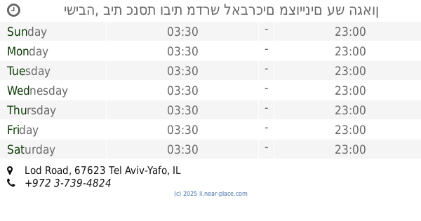
תל אביב יפו, ישראל
contacts phone
:
+972
Latitude:
32.053067
, Longitude:
34.805035
larger map & directions
read more
nearest Synagogue
265 m
David Synagogue plant
Tel Aviv-Yafo
Synagogue
read more
303 m
Ets Khayim Synagogue
Tel Aviv-Yafo
Synagogue
read more
357 m
מדרש כתר תורה לעולי מצרים
Tel Aviv-Yafo
Synagogue
read more
427 m
בית-כנסת אחוה
Tel Aviv-Yafo
Synagogue
read more
479 m
בית כנסת היכל הנס
Tel Aviv-Yafo
Synagogue
read more
491 m
בית כנסת ברית עולם
מעפילי אגוז 74, תל אביב יפו
Synagogue
read more
501 m
בית כנסת יסוד ציון
Tel Aviv-Yafo
Synagogue
read more
501 m
בית כנסת יסוד ציון
תל אביב יפו
Synagogue
read more
505 m
בית כנסת ספרדי אהבת ציון
מח"ל 51, תל אביב יפו
Synagogue
read more
590 m
The synagogue Neve IDF
Aluf Street 18, Tel Aviv-Yafo
Synagogue
read more
590 m
בית הכנסת נווה צה"ל
אלוף 18, תל אביב יפו
Synagogue
read more
679 m
עץ חיים -בית אל
Tsviya Lubetkin Street 26, Tel Aviv-Yafo
Synagogue
read more
704 m
בית כנסת שושן הבירה ליוצאי פרס
תקוע 8, תל אביב יפו
Synagogue
read more
729 m
בית הכנסת אוהל יוסף
תל אביב יפו
Synagogue
read more
780 m
בית כנסת חל-חײם
תל אביב יפו
Synagogue
read more
836 m
בית הכנסת הכללי בית הלל ופנחס
Tel Aviv-Yafo
Synagogue
read more
909 m
The synagogue and yeshiva named for Rabbi Shimon Bar Yochai
Lehi Road 97, Tel Aviv-Yafo
Synagogue
read more
909 m
בית הכנסת וישיבה עש רבי שמעון בר-יוחאי
Lehi Road 97, Tel Aviv-Yafo
Synagogue
read more
993 m
היכל הנס
HaTayasim Road 39, Ramat Gan
Synagogue
read more
998 m
בית כנסת בן-פורת
Lohamei Galipoli Street 2, Tel Aviv-Yafo
Synagogue
read more
1.002 km
בית כנסת עזרת אחים
תל אביב יפו
Synagogue
read more
1.124 km
בית הכנסת המרכזי הרמבם
HaMa'aracha Street 38, Tel Aviv-Yafo
Synagogue
read more
1.198 km
בית הכנסת זכרון קדושים
גבעתיים
Synagogue
read more
1.198 km
Synagogue holy memory
Giv'atayim
Synagogue
read more
1.259 km
ישיבה, בית כנסת ובית מדרש לאברכים מצויינים עש הגאון רבנו יוסף חיים זיעא
Lod Road, Tel Aviv-Yafo
Synagogue
read more
📑
all categories
Accounting
Administrative area level 1
Administrative area level 2
Airport
Amusement park
Aquarium
Art gallery
Atm
Bakery
Bank
Bar
Beauty salon
Bicycle store
Book store
Bowling alley
Bus station
Cafe
Campground
Car dealer
Car rental
Car repair
Car wash
Casino
Cemetery
Church
City hall
Clothing store
Colloquial area
Convenience store
Country
Courthouse
Dentist
Department store
Doctor
Electrician
Electronics store
Embassy
Establishment
Finance
Fire station
Florist
Food
Funeral home
Furniture store
Gas station
General contractor
Grocery or supermarket
Gym
Hair care
Hardware store
Health
Hindu Temple
Home goods store
Hospital
Insurance agency
Intersection
Jewelry store
Laundry
Lawyer
Library
Light rail station
Liquor store
Local government office
Locality
Locksmith
Lodging
Meal delivery
Meal takeaway
Mosque
Movie rental
Movie theater
Moving company
Museum
Natural feature
Neighborhood
Night club
Painter
Park
Parking
Pet store
Pharmacy
Physiotherapist
Place of worship
Plumber
Point of interest
Police
Political
Post office
Premise
Real estate agency
Restaurant
Roofing contractor
Route
Rv park, camping
School
Shoe store
Shopping mall
Spa
Stadium
Storage
Store
Subpremise
Subway station
Supermarket
Synagogue
Taxi stand
Train station
Transit station
Travel agency
University
Veterinary care
Zoo
administrative area level 3
administrative area level 4
sublocality level 1
↑