Synagogue nearby בית הכנסת המרכזי עש ר' שמעון בר יוחאי
Israel
Synagogue nearby בית הכנסת המרכזי עש ר' שמעון בר יוחאי
בית הכנסת המרכזי עש ר' שמעון בר יוחאי
Кирьят-Малахи, Израиль
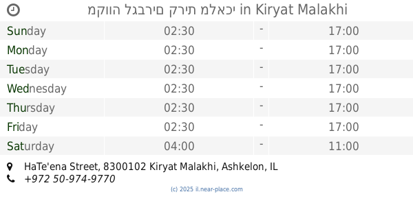
contacts phone
:
+972
Latitude:
31.734124
, Longitude:
34.748179
larger map & directions
read more
nearest Synagogue
בית הכנסת המרכזי עש ר' שמעון בר יוחאי
קרית מלאכי
Synagogue
read more
239 m
בית כנסת שבט יהודה
קרית מלאכי
Synagogue
read more
399 m
ביכ הליכות עולם
קרית מלאכי
Synagogue
read more
576 m
בית משיח
שדרות דוד בן גוריון 8, קרית מלאכי
Synagogue
read more
587 m
בית הכנסת אליהו הנביא
קרית מלאכי
Synagogue
read more
587 m
בית הכנסת אליהו הנביא
Kiryat Malakhi
Synagogue
read more
626 m
מגדל דוד
קרית מלאכי
Synagogue
read more
626 m
מגדל דוד
Kiryat Malakhi
Synagogue
read more
636 m
עולי בוכרה
קרית מלאכי
Synagogue
read more
636 m
עולי בוכרה
Kiryat Malakhi
Synagogue
read more
742 m
Rafael synagogue Ohel
Kiryat Malakhi
Synagogue
read more
744 m
Kiryat Malachi
Kiryat Malakhi
Synagogue
read more
759 m
חבדניצע שול
קרית מלאכי
Synagogue
read more
759 m
ביכ לזכרם של חללי צהל
קרית מלאכי
Synagogue
read more
759 m
חבדניצע שול
Kiryat Malakhi
Synagogue
read more
784 m
בית כנסת יד אליהו ושמחה
קרית מלאכי
Synagogue
read more
837 m
Bukharan synagogue congregation named Manny and Gazelle Nktlob
Kiryat Malakhi
Synagogue
read more
837 m
בית הכנסת לעדת הבוכרים ע"ש מני וצביה נקטלוב
קרית מלאכי
Synagogue
read more
947 m
Synagogue immigrants from Bukhara
Sderot Yerushalayim 16-24, Kiryat Malakhi
Synagogue
read more
980 m
בית הכנסת המרכזי - חבד
קרית מלאכי
Synagogue
read more
993 m
בית הכנסת חבסוב
נחלת הר חב"ד 9, קרית מלאכי
Synagogue
read more
993 m
The synagogue Hbsob
Nakhalat Har Khabad Street 9, Kiryat Malakhi
Synagogue
read more
996 m
בית הכנסת הגדול לעדה הבוכרית עש חבסוב
נחלת הר חב"ד 9, קרית מלאכי
Synagogue
read more
1.208 km
מקווה לגברים קרית מלאכי
תאנה קרית מלאכי 8300102
Synagogue
read more
1.215 km
מקווה לגברים קרית מלאכי
HaTe'ena Street, Kiryat Malakhi
Synagogue
read more
📑
all categories
Accounting
Administrative area level 1
Administrative area level 2
Airport
Amusement park
Aquarium
Art gallery
Atm
Bakery
Bank
Bar
Beauty salon
Bicycle store
Book store
Bowling alley
Bus station
Cafe
Campground
Car dealer
Car rental
Car repair
Car wash
Casino
Cemetery
Church
City hall
Clothing store
Colloquial area
Convenience store
Country
Courthouse
Dentist
Department store
Doctor
Electrician
Electronics store
Embassy
Establishment
Finance
Fire station
Florist
Food
Funeral home
Furniture store
Gas station
General contractor
Grocery or supermarket
Gym
Hair care
Hardware store
Health
Hindu Temple
Home goods store
Hospital
Insurance agency
Intersection
Jewelry store
Laundry
Lawyer
Library
Light rail station
Liquor store
Local government office
Locality
Locksmith
Lodging
Meal delivery
Meal takeaway
Mosque
Movie rental
Movie theater
Moving company
Museum
Natural feature
Neighborhood
Night club
Painter
Park
Parking
Pet store
Pharmacy
Physiotherapist
Place of worship
Plumber
Point of interest
Police
Political
Post office
Premise
Real estate agency
Restaurant
Roofing contractor
Route
Rv park, camping
School
Shoe store
Shopping mall
Spa
Stadium
Storage
Store
Subpremise
Subway station
Supermarket
Synagogue
Taxi stand
Train station
Transit station
Travel agency
University
Veterinary care
Zoo
administrative area level 3
administrative area level 4
sublocality level 1
↑