Synagogue nearby ביאלה
Israel
Synagogue nearby ביאלה
ביאלה
האמרכלים 8-20, ירושלים ישראל
contacts phone
:
+972
Latitude:
31.7880884
, Longitude:
35.2151211
read more
nearest Synagogue
98 m
Beit El Synagogue
Rashi Street 24, Jerusalem
Synagogue
read more
132 m
בית כנסת אמונת ישראל
חפץ חיים 23, ירושלים
Synagogue
read more
134 m
בית כנסת שאול מזרחי
ירושלים
Synagogue
read more
210 m
בית וועד לחכמים ירושלים
Nahum Street 9, Jerusalem
Synagogue
read more
215 m
Bayan synagogue Hornstein houses Jerusalem
Reshit Khokhma Street 22, Jerusalem
Synagogue
read more
242 m
בית הכנסת אהל שמואל כהן יהודית יזדי
ירושלים
Synagogue
read more
257 m
Beit Knesset Komarno
Malkei Israel Street 6-10, Jerusalem
Synagogue
read more
335 m
בית הכנסת אהל אברהם
רשב"ם 9, ירושלים
Synagogue
read more
543 m
בית הכנסת המרכזי ברוכוף
רחובות הבוכרים 21, ירושלים
Synagogue
read more
561 m
ביהכ אגודת צעירי פרס
Agripas Street 129, Jerusalem
Synagogue
read more
622 m
שטיבל גור - ברנדייס
Luis Brandeis Street 2, Jerusalem
Synagogue
read more
656 m
Zichron Menachem Synagogue - Rand Homes
Shomron Street 40-54, Jerusalem
Synagogue
read more
700 m
The study Sanz Klausenburg
Evyatar HaCohen Street 8, Jerusalem
Synagogue
read more
741 m
קהל חסידי ירושלים
Shlomo Musayof Street 14, Jerusalem
Synagogue
read more
884 m
בית כנסת קהילת זוועהיל
שמואל הנביא 73, ירושלים
Synagogue
read more
905 m
בית הכנסת הגדול, ברסלב ירושלים
הרב שמואל סלנט 36, ירושלים
Synagogue
read more
917 m
בית הכנסת האיטלקי
הלל, ירושלים
Synagogue
read more
926 m
בית כנסת קרני
Shim'on Rokah Street 54, Jerusalem
Synagogue
read more
941 m
בית הכנסת
Jerusalem
Synagogue
read more
991 m
Light of Life Synagogue
Ets Hadar Street 7, Jerusalem
Synagogue
read more
1.015 km
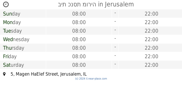
בית כנסת מוריה
Magen HaElef Street 5, Jerusalem
Synagogue
read more
1.033 km
Ahavat Shalom Beit Midrash
Petahia Street 11, Jerusalem
Synagogue
read more
1.048 km
בית כנסת נווה שלום
שאול המלך, ירושלים
Synagogue
read more
1.108 km
בית כנסת כנסת יעקב
Petakh Tikva Street 16, Jerusalem
Synagogue
read more
1.195 km
Synagogue Safra
ירושלים
Synagogue
read more
📑
all categories
Accounting
Administrative area level 1
Administrative area level 2
Airport
Amusement park
Aquarium
Art gallery
Atm
Bakery
Bank
Bar
Beauty salon
Bicycle store
Book store
Bowling alley
Bus station
Cafe
Campground
Car dealer
Car rental
Car repair
Car wash
Casino
Cemetery
Church
City hall
Clothing store
Colloquial area
Convenience store
Country
Courthouse
Dentist
Department store
Doctor
Electrician
Electronics store
Embassy
Establishment
Finance
Fire station
Florist
Food
Funeral home
Furniture store
Gas station
General contractor
Grocery or supermarket
Gym
Hair care
Hardware store
Health
Hindu Temple
Home goods store
Hospital
Insurance agency
Intersection
Jewelry store
Laundry
Lawyer
Library
Light rail station
Liquor store
Local government office
Locality
Locksmith
Lodging
Meal delivery
Meal takeaway
Mosque
Movie rental
Movie theater
Moving company
Museum
Natural feature
Neighborhood
Night club
Painter
Park
Parking
Pet store
Pharmacy
Physiotherapist
Place of worship
Plumber
Point of interest
Police
Political
Post office
Premise
Real estate agency
Restaurant
Roofing contractor
Route
Rv park, camping
School
Shoe store
Shopping mall
Spa
Stadium
Storage
Store
Subpremise
Subway station
Supermarket
Synagogue
Taxi stand
Train station
Transit station
Travel agency
University
Veterinary care
Zoo
administrative area level 3
administrative area level 4
sublocality level 1
↑