Synagogue nearby ביכ אל גטאר
Israel
Synagogue nearby ביכ אל גטאר
ביכ אל גטאר
אדורה
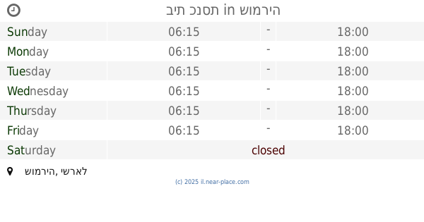
contacts phone
:
+972
Latitude:
31.551123
, Longitude:
35.016273
larger map & directions
read more
nearest Synagogue
8.543 km
קבר נתן הנביא
Halhul
Synagogue
read more
8.574 km
בית כנסת אוהל משה
אליאב
Synagogue
read more
8.574 km
בית כנסת אוהל משה
Eliav
Synagogue
read more
8.837 km
Ishai Tomb
Israel
Synagogue
read more
8.839 km
קבר רות
Israel
Synagogue
read more
8.84 km
Avner Ben Ner Tomb
Israel
Synagogue
read more
8.842 km
קבר עתניאל בן קנז
Israel
Synagogue
read more
8.842 km
Otni'el Ben Knaz Tomb
Israel
Synagogue
read more
9.417 km
קבר אדם וחווה
Israel
Synagogue
read more
9.421 km
קבר יצחק ורבקה
Israel
Synagogue
read more
9.752 km
Central synagogue Bni Dklim
Bnei Dkalim
Synagogue
read more
9.836 km
בית חיה מושקא - חבד
גור אריה, קרית ארבע
Synagogue
read more
10.398 km
קשת רהיטי עץ ומתכת
אזור התעשייה, קרית ארבע, ירושלים
Synagogue
read more
17.318 km
Beit Aharon Aharon Synagogue
Ha-Gefen Street, Efrat
Synagogue
read more
18.174 km
בית כנסת
שומריה
Synagogue
read more
18.412 km
Neve Daniel Synagogue
Neve Daniel
Synagogue
read more
18.695 km
בית כנסת אור חביב
שדרות דוד המלך 72, אפרת
Synagogue
read more
18.695 km
Aor Hbib synagogue
Sderot David HaMelech 72, Efrat
Synagogue
read more
19.356 km
בית כנסת הספרדי המרכזי בזית
יהודה המכבי 8, אפרת
Synagogue
read more
19.356 km
בית כנסת שטיבלאך חרדי
ריב"ל 16-20, בית שמש
Synagogue
read more
19.781 km
בית כנסת כפות תמרים
HaTsiporen Street 5, Efrat
Synagogue
read more
21.094 km
בית הכנסת בני הישיבות היכל אברהם
Bet Shemesh
Synagogue
read more
26.618 km
בית כנסת ר' חי טייב
ירושלים
Synagogue
read more
28.793 km
בית מדרש דחסידי סוכוטשוב-ראדומסק
החיד"א 4, ירושלים
Synagogue
read more
29.387 km
ביכ רמה
ירושלים
Synagogue
read more
📑
all categories
Accounting
Administrative area level 1
Administrative area level 2
Airport
Amusement park
Aquarium
Art gallery
Atm
Bakery
Bank
Bar
Beauty salon
Bicycle store
Book store
Bowling alley
Bus station
Cafe
Campground
Car dealer
Car rental
Car repair
Car wash
Casino
Cemetery
Church
City hall
Clothing store
Colloquial area
Convenience store
Country
Courthouse
Dentist
Department store
Doctor
Electrician
Electronics store
Embassy
Establishment
Finance
Fire station
Florist
Food
Funeral home
Furniture store
Gas station
General contractor
Grocery or supermarket
Gym
Hair care
Hardware store
Health
Hindu Temple
Home goods store
Hospital
Insurance agency
Intersection
Jewelry store
Laundry
Lawyer
Library
Light rail station
Liquor store
Local government office
Locality
Locksmith
Lodging
Meal delivery
Meal takeaway
Mosque
Movie rental
Movie theater
Moving company
Museum
Natural feature
Neighborhood
Night club
Painter
Park
Parking
Pet store
Pharmacy
Physiotherapist
Place of worship
Plumber
Point of interest
Police
Political
Post office
Premise
Real estate agency
Restaurant
Roofing contractor
Route
Rv park, camping
School
Shoe store
Shopping mall
Spa
Stadium
Storage
Store
Subpremise
Subway station
Supermarket
Synagogue
Taxi stand
Train station
Transit station
Travel agency
University
Veterinary care
Zoo
administrative area level 3
administrative area level 4
sublocality level 1
↑