Store nearby זיסלנד
Israel
Store nearby זיסלנד
זיסלנד
אהבת שלום 2, בני ברק ישראל
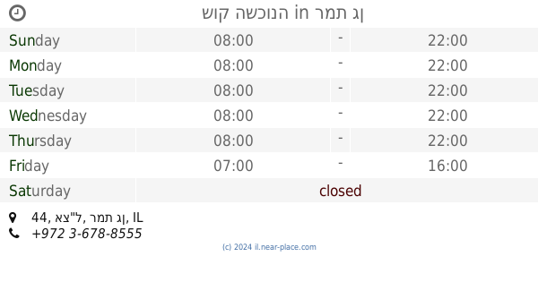
contacts phone
:
+972
Latitude:
32.0767707
, Longitude:
34.8367506
read more
nearest Store
280 m
drop smoke דראפ סמאק
נחמיה 19, בני ברק
Store
read more
477 m
מתנה בטעם - המרכז למתנות ועיצובי פירות
ישמח משה 36, בני ברק
Store
read more
499 m
אוטו בני ברק
שלמה המלך 7, בני ברק
Store
read more
623 m
ביסלה
Ezra Street 4, Bnei Brak
Store
read more
624 m
Konfti- center plates and cups
Sderot Yerushalayim 89, Ramat Gan
Store
read more
644 m
ברוורמן-השכרת רכב ותיירות
HaRav Meltser Street 21, Bnei Brak
Store
read more
680 m
פיצוחי עושמי
ד"ר נתן בירנבוים 19, בני ברק
Store
read more
760 m
אפריון - החברה המובילה בתחום הפקות חינה
Ha-Rav Sonnenfeld Street 20, Bnei Brak
Store
read more
761 m
הממחה לניקוי יבש דניאלציק חיים
הרב כהנמן 64, בני ברק
Store
read more
791 m
ספיישל פרי
בארי 6, בני ברק
Store
read more
899 m
צעצועית
אבני נזר 7, בני ברק
Store
read more
925 m
דואית
David Ben Gurion Street 11, Giv'at Shmuel
Store
read more
928 m
אדני הקודש
שדרות לוחמי הגטאות 11, גבעת שמואל
Store
read more
959 m
קופיקס
9, חיים לנדאו 7A, רמת גן
Store
read more
965 m
שוק השכונה
אצ"ל 44, רמת גן
Store
read more
968 m
תחכמוני
רבי עקיבא 146, בני ברק
Store
read more
971 m
BODY SHOP
חיים לנדאו 7, רמת גן
Store
read more
980 m
Rudi
Khayim Landau Street 7A, Ramat Gan
Store
read more
987 m
Egozim
חיים לנדאו 7A, רמת גן
Store
read more
998 m
Wertheimer Sports
חיים לנדאו 7A, רמת גן
Store
read more
998 m
Wertheimer Sports
Khayim Landau Street 7A, Ramat Gan
Store
read more
1.003 km
מרכז שעונים וכלי כסף
רבי עקיבא 124, בני ברק
Store
read more
1.017 km
כלי נקי
Rabi Akiva Street 145, Bnei Brak
Store
read more
1.017 km
כלי נקי
רבי עקיבא 145, בני ברק
Store
read more
1.02 km
כיסופים
Rabi Akiva Street 118, Bnei Brak
Store
read more
📑
all categories
Accounting
Administrative area level 1
Administrative area level 2
Airport
Amusement park
Aquarium
Art gallery
Atm
Bakery
Bank
Bar
Beauty salon
Bicycle store
Book store
Bowling alley
Bus station
Cafe
Campground
Car dealer
Car rental
Car repair
Car wash
Casino
Cemetery
Church
City hall
Clothing store
Colloquial area
Convenience store
Country
Courthouse
Dentist
Department store
Doctor
Electrician
Electronics store
Embassy
Establishment
Finance
Fire station
Florist
Food
Funeral home
Furniture store
Gas station
General contractor
Grocery or supermarket
Gym
Hair care
Hardware store
Health
Hindu Temple
Home goods store
Hospital
Insurance agency
Intersection
Jewelry store
Laundry
Lawyer
Library
Light rail station
Liquor store
Local government office
Locality
Locksmith
Lodging
Meal delivery
Meal takeaway
Mosque
Movie rental
Movie theater
Moving company
Museum
Natural feature
Neighborhood
Night club
Painter
Park
Parking
Pet store
Pharmacy
Physiotherapist
Place of worship
Plumber
Point of interest
Police
Political
Post office
Premise
Real estate agency
Restaurant
Roofing contractor
Route
Rv park, camping
School
Shoe store
Shopping mall
Spa
Stadium
Storage
Store
Subpremise
Subway station
Supermarket
Synagogue
Taxi stand
Train station
Transit station
Travel agency
University
Veterinary care
Zoo
administrative area level 3
administrative area level 4
sublocality level 1
↑