Store nearby X ray lunettes
Israel
Store nearby X ray lunettes
X ray lunettes
23, Sheinkin Street, Tel Aviv-Yafo, IL Израиль
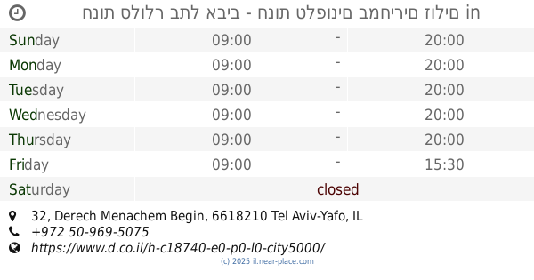
contacts phone
:
+972
Latitude:
32.0688062
, Longitude:
34.7753642
larger map & directions
read more
nearest Store
437 m
נוריאל משה
אלנבי 94, תל אביב יפו
Store
read more
469 m
יפית מפה ומפית
נחלת בנימין 1, תל אביב יפו
Store
read more
474 m
Body Shop
Allenby Street 98, Tel Aviv-Yafo
Store
read more
510 m
A2 Z Yavne
ת.ד 421, יבנה
Store
read more
549 m
Nippon Premium brands made in Japan
טשרניחובסקי 21, תל אביב יפו
Store
read more
557 m
אלגנט
Nahalat Binyamin Street 33, Tel Aviv-Yafo
Store
read more
613 m
Even Gallery
Rabbi Meir Street 40, Tel Aviv-Yafo
Store
read more
719 m
האחים קוואז בעמ
Derech Menachem Begin 27, Tel Aviv-Yafo
Store
read more
724 m
דווקא גורמה
הכרמל 34, תל אביב יפו
Store
read more
736 m
קרביץ דיזינגוף
קניון דיזנגוף, דיזנגוף 50, תל אביב יפו
Store
read more
788 m
אדידס
דיזנגוף 50, תל אביב יפו
Store
read more
808 m
Green Vaper
Bar Giyora Street 26, Tel Aviv-Yafo
Store
read more
820 m
חנות סלולר בתל אביב - חנות טלפונים במחירים זולים
Derech Menachem Begin 32, Tel Aviv-Yafo
Cafe
Food
Point of interest
Store
Establishment
read more
900 m
קפש אבני חן בעמ
Allenby Street 123, Tel Aviv-Yafo
Store
read more
906 m
מסלול עודפים
44, Bograshov Street, Tel Aviv-Yafo
Store
read more
907 m
ע.ר.הדפסות בע"מ
Rival Street 6, Tel Aviv-Yafo
Store
read more
924 m
Avnet Belts
81, Dizengoff Street, Tel Aviv-Yafo
Store
read more
962 m
Blitz Electric Motors
HaGdud Haivri Street 12, Tel Aviv-Yafo
Store
read more
967 m
גל מכשירי שמיעה בע"מ
Zamenhoff Street 32, Tel Aviv-Yafo
Store
read more
998 m
Smashbox
HaHashmonaim Street 96, Tel Aviv-Yafo
Store
read more
998 m
Emanuel 1
החשמונאים 96, תל אביב יפו
Store
read more
1.08 km
אניטה
שבזי פינת פינס 40, תל אביב יפו
Store
read more
1.084 km
בראנצו׳ס
58, Retsif Herbert Samuel Street, Tel Aviv-Yafo
Store
read more
1.086 km
CONVERSION
Ben Yehuda Street 32, Tel Aviv-Yafo
Store
read more
1.241 km
שושו סנטר
הירקון 88, תל אביב יפו
Store
read more
📑
all categories
Accounting
Administrative area level 1
Administrative area level 2
Airport
Amusement park
Aquarium
Art gallery
Atm
Bakery
Bank
Bar
Beauty salon
Bicycle store
Book store
Bowling alley
Bus station
Cafe
Campground
Car dealer
Car rental
Car repair
Car wash
Casino
Cemetery
Church
City hall
Clothing store
Colloquial area
Convenience store
Country
Courthouse
Dentist
Department store
Doctor
Electrician
Electronics store
Embassy
Establishment
Finance
Fire station
Florist
Food
Funeral home
Furniture store
Gas station
General contractor
Grocery or supermarket
Gym
Hair care
Hardware store
Health
Hindu Temple
Home goods store
Hospital
Insurance agency
Intersection
Jewelry store
Laundry
Lawyer
Library
Light rail station
Liquor store
Local government office
Locality
Locksmith
Lodging
Meal delivery
Meal takeaway
Mosque
Movie rental
Movie theater
Moving company
Museum
Natural feature
Neighborhood
Night club
Painter
Park
Parking
Pet store
Pharmacy
Physiotherapist
Place of worship
Plumber
Point of interest
Police
Political
Post office
Premise
Real estate agency
Restaurant
Roofing contractor
Route
Rv park, camping
School
Shoe store
Shopping mall
Spa
Stadium
Storage
Store
Subpremise
Subway station
Supermarket
Synagogue
Taxi stand
Train station
Transit station
Travel agency
University
Veterinary care
Zoo
administrative area level 3
administrative area level 4
sublocality level 1
↑