Store nearby תבליני עזאני
Israel
Store nearby תבליני עזאני
תבליני עזאני
28, אצ"ל, רמת גן, IL ישראל
contacts phone
:
+972
Latitude:
32.0663815
, Longitude:
34.8351121
larger map & directions
read more
nearest Store
132 m
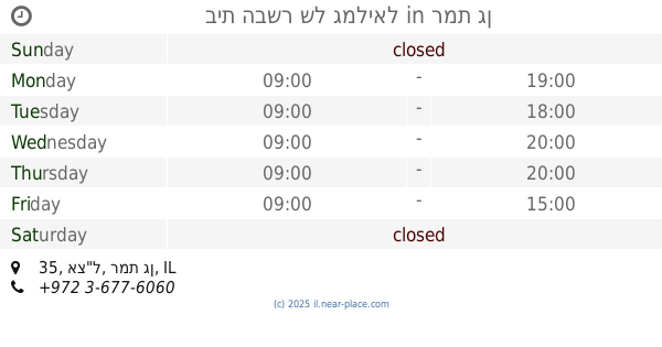
בית הבשר של גמליאל
אצ"ל 35, רמת גן
Store
read more
259 m
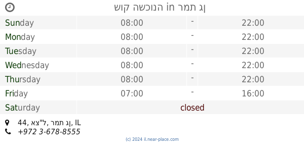
שוק השכונה
אצ"ל 44, רמת גן
Store
read more
301 m
בוניטה קוסמטיקה טכנולוגיה וטיפוח
Hakabaim Street 3, Ramat Gan
Store
read more
698 m
Boboim
Simtat Albert 1, Ramat Gan
Store
read more
788 m
פיצוחי עושמי
ד"ר נתן בירנבוים 19, בני ברק
Store
read more
817 m
Café Café
מרכז מרום נווה, תרצה 19, רמת גן
Cafe
Restaurant
Food
Point of interest
Store
Establishment
read more
827 m
VIP Cosmetics
Derech Negba 36, Ramat Gan
Store
read more
842 m
סבן חומרי בניין
Ramat Gan
Store
read more
860 m
Rudi
Khayim Landau Street 7A, Ramat Gan
Store
read more
870 m
cofix
9, Khayim Landau Street 7A, Ramat Gan
Store
read more
870 m
קופיקס
9, חיים לנדאו 7A, רמת גן
Store
read more
870 m
Кофикс
9, Khayim Landau Street 7A, Ramat Gan
Store
read more
871 m
BODY SHOP
Khayim Landau Street 7, Ramat Gan
Store
read more
871 m
BODY SHOP
חיים לנדאו 7, רמת גן
Store
read more
872 m
Egozim
חיים לנדאו 7A, רמת גן
Store
read more
881 m
Wertheimer Sports
חיים לנדאו 7A, רמת גן
Store
read more
881 m
Wertheimer Sports
Khayim Landau Street 7A, Ramat Gan
Store
read more
906 m
זולו לחיות מחמד סניף נגבה
Derech Negba 41, Ramat Gan
Store
read more
912 m
המכירה של ספיר
תרצה 28, רמת גן
Store
read more
959 m
ביגרף
בני, Imrei Baruch Street 10, ברק
Store
read more
965 m
פלד חותמות
קושניר 18, בני ברק
Store
read more
1.036 km
כחילה פתרונות הדפסה בעמ
דרך נגבה 20, רמת גן
Store
read more
1.039 km
Konfti- center plates and cups
Sderot Yerushalayim 89, Ramat Gan
Store
read more
1.048 km
עולם החי רמת גן
דרך נגבה 18, רמת גן
Store
read more
1.306 km
כנפיים בית הספר לטיסנאות עכשווית
הרא"ה 163, רמת גן
Store
read more
📑
all categories
Accounting
Administrative area level 1
Administrative area level 2
Airport
Amusement park
Aquarium
Art gallery
Atm
Bakery
Bank
Bar
Beauty salon
Bicycle store
Book store
Bowling alley
Bus station
Cafe
Campground
Car dealer
Car rental
Car repair
Car wash
Casino
Cemetery
Church
City hall
Clothing store
Colloquial area
Convenience store
Country
Courthouse
Dentist
Department store
Doctor
Electrician
Electronics store
Embassy
Establishment
Finance
Fire station
Florist
Food
Funeral home
Furniture store
Gas station
General contractor
Grocery or supermarket
Gym
Hair care
Hardware store
Health
Hindu Temple
Home goods store
Hospital
Insurance agency
Intersection
Jewelry store
Laundry
Lawyer
Library
Light rail station
Liquor store
Local government office
Locality
Locksmith
Lodging
Meal delivery
Meal takeaway
Mosque
Movie rental
Movie theater
Moving company
Museum
Natural feature
Neighborhood
Night club
Painter
Park
Parking
Pet store
Pharmacy
Physiotherapist
Place of worship
Plumber
Point of interest
Police
Political
Post office
Premise
Real estate agency
Restaurant
Roofing contractor
Route
Rv park, camping
School
Shoe store
Shopping mall
Spa
Stadium
Storage
Store
Subpremise
Subway station
Supermarket
Synagogue
Taxi stand
Train station
Transit station
Travel agency
University
Veterinary care
Zoo
administrative area level 3
administrative area level 4
sublocality level 1
↑